File:Table iceberg west of Sjuøyane, Arctic ocean.jpg
Jump to navigation
Jump to search

Size of this preview: 800 × 450 pixels. Other resolutions: 320 × 180 pixels | 640 × 360 pixels | 1,024 × 576 pixels | 1,280 × 720 pixels | 2,560 × 1,440 pixels | 4,597 × 2,586 pixels.
Original file (4,597 × 2,586 pixels, file size: 7.66 MB, MIME type: image/jpeg)
Captions
Captions
Add a one-line explanation of what this file represents
Summary
[edit]
| Description |
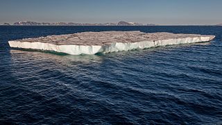
English: Table icebergs are very rare in the Arctic as they calve from shelf ice, which is rarely found in the north. They are normally a typical form of icebergs in the Antarctic. This one has an estimated height of 10-12m and a size of half a soccer field.
Deutsch: Tafeleisberge sind sehr selten in der Arktis zu finden, sie sind eigentlich eine typische Erscheinung für die Antarktis. Sie entstehen durch Kalbung von Schelfeis, das in der Arktis kaum vorkommt. Dieser Tafeleisberg ist geschätzte 10 bis 12m hoch und hat eine Fläche von etwa einem halben Fußballfeld. |
| Date | |
| Source | Own work |
| Author | Andreas Weith |
|
| Camera location | | View this and other nearby images on: OpenStreetMap |
|---|
Licensing
[edit]
I, the copyright holder of this work, hereby publish it under the following license:
This file is licensed under the Creative Commons Attribution-Share Alike 4.0 International license.
- You are free:
- to share – to copy, distribute and transmit the work
- to remix – to adapt the work
- Under the following conditions:
- attribution – You must give appropriate credit, provide a link to the license, and indicate if changes were made. You may do so in any reasonable manner, but not in any way that suggests the licensor endorses you or your use.
- share alike – If you remix, transform, or build upon the material, you must distribute your contributions under the same or compatible license as the original.
This image has been assessed using the Quality image guidelines and is considered a Quality image.
|
File history
Click on a date/time to view the file as it appeared at that time.
| Date/Time | Thumbnail | Dimensions | User | Comment | |
|---|---|---|---|---|---|
| current | 00:02, 3 November 2016 | | 4,597 × 2,586 (7.66 MB) | AWeith (talk | contribs) | User created page with UploadWizard |
You cannot overwrite this file.
File usage on Commons
The following 21 pages use this file:
- Ice
- User:AWeith
- User:Daniel Mietchen/POTY/2016
- User:Meiræ/17
- User:Zyephyrus/2016
- User:Überraschungsbilder/Archiv/2017
- User:Спасимир/Favorites
- User talk:AWeith/Archive 2
- User talk:Ikan Kekek/archive
- Commons:Featured picture candidates/File:Table iceberg west of Sjuøyane, Arctic ocean.jpg
- Commons:Featured picture candidates/Log/November 2016
- Commons:Featured pictures/Natural phenomena
- Commons:Featured pictures/chronological/2016-B
- Commons:Picture of the Year/2016/Candidates
- Commons:Picture of the Year/2016/R1/Gallery/2016-B
- Commons:Picture of the Year/2016/R1/Gallery/ALL
- Commons:Picture of the Year/2016/R1/Gallery/M11
- Commons:Picture of the Year/2016/R1/Gallery/Waters
- Commons:Picture of the Year/2016/R1/v/Table iceberg west of Sjuøyane, Arctic ocean.jpg
- Commons:Quality images/Subject/Places/Natural structures/Panorama/Archive 2016
- Commons:Quality images candidates/Archives November 05 2016
File usage on other wikis
The following other wikis use this file:
- Usage on de.wikipedia.org
- Usage on en.wikipedia.org
- Usage on fr.wiktionary.org
- Usage on mr.wikipedia.org