File:Syrmia.png
Jump to navigation
Jump to search

Size of this preview: 800 × 489 pixels. Other resolutions: 320 × 196 pixels | 640 × 392 pixels | 1,082 × 662 pixels.
Original file (1,082 × 662 pixels, file size: 58 KB, MIME type: image/png)
Captions
Captions
Add a one-line explanation of what this file represents
Summary
[edit]
| Description |
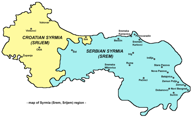
English: Map of Syrmia region.
Српски / srpski: Мапа Срема
Hrvatski: Mapa Srijema |
| Date | 28 December 2006 (original upload date) |
| Source | Own work |
| Author | PANONIAN |
Licensing
[edit]
self made map by user:PANONIAN

|
This map has been uploaded by Electionworld from en.wikipedia.org to enable the |
| I, the copyright holder of this work, release this work into the public domain. This applies worldwide. In some countries this may not be legally possible; if so: I grant anyone the right to use this work for any purpose, without any conditions, unless such conditions are required by law. |
References
[edit]
References for historical/geographical borders of Syrmia and modern state borders:
- Školski istorijski atlas, Zavod za izdavanje udžbenika Socijalističke Republike Srbije, Beograd, 1970.
- Milovan Radovanović, Kosovo i Metohija - antropogeografske, istorijskogeografske, demografske i geopolitičke osnove, Beograd, 2008.
- Slobodan Radovanović, Geografski atlas, Magic Map, Smederevska Palanka, 2001.
- Školski geografski atlas, Intersistem Kartografija, Beograd, 2004.
- Denis Šehić - Demir Šehić, Geografski atlas Srbije, Beograd, 2007.
References for sizable cities and towns:
- Popis stanovništva, domaćinstava i stanova u 2002., Stanovništvo, nacionalna ili etnička pripadnost - Podaci po naseljima, knjiga 1, Republika Srbija - Republički zavod za statistiku, Beograd, februar 2003.
- http://world-gazetteer.com/ archive copy at the Wayback Machine
Other versions
[edit]
- Russian language version - File:Срем.png
File history
Click on a date/time to view the file as it appeared at that time.
| Date/Time | Thumbnail | Dimensions | User | Comment | |
|---|---|---|---|---|---|
| current | 21:16, 16 September 2009 | | 1,082 × 662 (58 KB) | PANONIAN (talk | contribs) | Reverted to version as of 21:14, 16 September 2009 - fixing thumbnail problem |
| 21:16, 16 September 2009 |  | 1,008 × 600 (41 KB) | PANONIAN (talk | contribs) | Reverted to version as of 15:31, 28 December 2006 - fixing thumbnail problem | |
| 21:14, 16 September 2009 |  | 1,082 × 662 (58 KB) | PANONIAN (talk | contribs) | ||
| 15:31, 28 December 2006 |  | 1,008 × 600 (41 KB) | Electionworld (talk | contribs) | {{ew|en|PANONIAN}} Map of Syrmia region (self made) {{PD-self}} Category:Maps of Vojvodina Category:Maps of Serbia Category:Maps of Croatia |
You cannot overwrite this file.
File usage on Commons
The following 3 pages use this file:
File usage on other wikis
The following other wikis use this file:
- Usage on an.wikipedia.org
- Usage on bs.wikipedia.org
- Usage on ca.wikipedia.org
- Usage on cs.wikipedia.org
- Usage on de.wikipedia.org
- Usage on de.wiktionary.org
- Usage on en.wikipedia.org
- Usage on eo.wikipedia.org
- Usage on es.wikipedia.org
- Usage on et.wikipedia.org
- Usage on fr.wikipedia.org
- Usage on gl.wikipedia.org
- Usage on hr.wikipedia.org
- Usage on hu.wikipedia.org
- Usage on id.wikipedia.org
- Usage on it.wikipedia.org
- Usage on ja.wikipedia.org
- Usage on ko.wikipedia.org
- Usage on mk.wikipedia.org
- Usage on nl.wikipedia.org
- Usage on nn.wikipedia.org
- Usage on pl.wikipedia.org
- Usage on pt.wikipedia.org
- Usage on ro.wikipedia.org
- Usage on rue.wikipedia.org
- Usage on sh.wikipedia.org
- Usage on sk.wikipedia.org
- Usage on sq.wikipedia.org
- Usage on sv.wikipedia.org
- Usage on tr.wikipedia.org
- Usage on uk.wikipedia.org
- Usage on zh.wikipedia.org