File:Polska 960 - 992.png
Jump to navigation
Jump to search

Size of this preview: 608 × 599 pixels. Other resolutions: 243 × 240 pixels | 487 × 480 pixels | 779 × 768 pixels | 1,039 × 1,024 pixels | 1,854 × 1,828 pixels.
Original file (1,854 × 1,828 pixels, file size: 1.45 MB, MIME type: image/png)
Captions
Captions
Add a one-line explanation of what this file represents

|
File:Polska 960 - 992.svg is a vector version of this file. It should be used in place of this PNG file when not inferior.
File:Polska 960 - 992.png → File:Polska 960 - 992.svg
For more information, see Help:SVG. |
 |
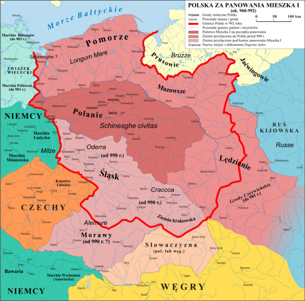
| Description | Mapa Polski za panowania Mieszka I (ok. 960 - 992) |
| Date | 2.01.2007 |
| Source | własna praca na podstawie: "Ilustrowany Atlas Historii Polski" i publikacji o badaniach na Ostrowie Tumskim w Poznaniu. |
| Author | Poznaniak, Popik |
| Permission (Reusing this file) |
I, the copyright holder of this work, hereby publish it under the following license: This file is licensed under the Creative Commons Attribution-Share Alike 3.0 Unported license.
|
| Other versions | Derivative works of this file: Polen 960-992.png |
File history
Click on a date/time to view the file as it appeared at that time.
| Date/Time | Thumbnail | Dimensions | User | Comment | |
|---|---|---|---|---|---|
| current | 19:57, 14 November 2020 | | 1,854 × 1,828 (1.45 MB) | Popik (talk | contribs) | Techniczne |
| 19:46, 14 November 2020 |  | 2,646 × 2,561 (2.34 MB) | Popik (talk | contribs) | Kolory, Ołomuniec (wg Urbańczyk 2010) | |
| 12:40, 4 November 2020 |  | 11,517 × 11,361 (15.58 MB) | Popik (talk | contribs) | Popr. terytorium Niemiec. | |
| 15:14, 10 July 2020 |  | 2,309 × 2,278 (2.03 MB) | Popik (talk | contribs) | Granica wschodnia na podstawie Wł. Semkowicz "Mały atlas historyczny" | |
| 10:10, 8 July 2020 |  | 2,309 × 2,278 (2.04 MB) | Popik (talk | contribs) | Kilka zmian uwzględniających mapy i monografie: Stanisław Zakrzewski "Mieszko I jako budowniczy państwa polskiego" (zasięg Grodów Czerwieńskich na wschodzie, prawdopodobna przynależność Moraw do Polski a Słowaczyzny do Węgier, zasięg Rusi Kijowskiej, granice Milska i Łużyc), Władysław Semkowicz "Mały atlas historyczny" (możliwa przynależność Słowaczyzny do Polski, zasięg Milska i Łużyc oraz Śląska i Z. Krakowskiej), Gerard Labuda "Mieszko I" (Lędzianie), Jerzy Strzelczyk "Mieszko Pierwszy" (p... | |
| 16:14, 31 May 2019 |  | 2,309 × 2,279 (1.09 MB) | Poznaniak (talk | contribs) | Reverted to version as of 20:00, 13 July 2017 (UTC) | |
| 17:29, 29 May 2019 |  | 2,309 × 2,279 (2.02 MB) | E-960 (talk | contribs) | Date fix | |
| 17:10, 28 May 2019 |  | 2,309 × 2,279 (2.01 MB) | E-960 (talk | contribs) | Common name | |
| 20:00, 13 July 2017 |  | 2,309 × 2,279 (1.09 MB) | Emptywords (talk | contribs) | Removed "capital cities", becouse there were no capital cities at that time. After discussion at pl.wikipedia. | |
| 15:36, 3 October 2013 |  | 2,309 × 2,279 (1.12 MB) | Poznaniak (talk | contribs) | Reverted to version as of 12:05, 7 October 2010 |
You cannot overwrite this file.
File usage on Commons
The following 3 pages use this file:
File usage on other wikis
The following other wikis use this file:
- Usage on bg.wikipedia.org
- Usage on ca.wikipedia.org
- Usage on cs.wikipedia.org
- Usage on de.wikipedia.org
- Usage on el.wikipedia.org
- Usage on en.wikipedia.org
- Usage on eo.wikipedia.org
- Usage on es.wikipedia.org
- Usage on et.wikipedia.org
- Usage on fr.wikipedia.org
- Usage on he.wikipedia.org
- Usage on id.wikibooks.org
- Usage on it.wikipedia.org
- Usage on ko.wikipedia.org
- Usage on la.wikipedia.org
- Usage on lt.wikipedia.org
- Usage on nn.wikipedia.org
- Usage on no.wikipedia.org
- Usage on pl.wikipedia.org
View more global usage of this file.