File:PIA00271 Venus (Computer Simulated Global View of the Northern Hemisphere).jpg
Jump to navigation
Jump to search

Size of this preview: 600 × 600 pixels. Other resolutions: 240 × 240 pixels | 480 × 480 pixels | 768 × 768 pixels | 1,024 × 1,024 pixels | 2,048 × 2,048 pixels | 4,096 × 4,096 pixels.
Original file (4,096 × 4,096 pixels, file size: 1.68 MB, MIME type: image/jpeg)
Captions
Captions
Add a one-line explanation of what this file represents
Summary
[edit]| Description |
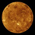
English: The northern hemisphere is displayed in this global view of the surface of Venus. The north pole is at the center of the image, with 0 degrees, 90 degrees, 180 degrees, 270 degrees east longitudes at the 6, 3, 12, and 9 o'clock positions, respectively, of an imaginary clock face. Magellan synthetic aperture radar mosaics from the three eight-month cycles of Magellan radar mapping are mapped onto a computer-simulated globe to create this image. Magellan obtained coverage of 98 percent of the surface of Venus. Remaining gaps are filled with data from previous missions, (the Soviet Venera 15 and 16 radar and Pioneer Venus Orbiter altimetry) and data from Earth-based radar observations from the Arecibo radio telescope. Simulated color is used to enhance small-scale structures. The simulated hues are based on color images recorded by the Venera 13 and 14 landing craft. Maxwell Montes, the planet's highest mountain at 11 kilometers (6.6 miles) above the average elevation, is the bright feature in the lower center of the image. Other terrain types visible in this image include tessera, ridge belts, lava flows, impact craters and coronae. The image was produced by the Solar System Visualization Project and the Magellan Science team at the Jet Propulsion Laboratory Multimission Image Processing Laboratory. The Magellan mission is managed by JPL for NASA's Office of Space Science. |
| Date | between 1990 and 1991 |
| Source | https://photojournal.jpl.nasa.gov/catalog/PIA00271 |
| Author | NASA/JPL |
| Other versions |
|

.jpg&action=edit§ion=1)
Licensing
[edit].jpg&action=edit§ion=2)
| This file is in the public domain in the United States because it was solely created by NASA. NASA copyright policy states that "NASA material is not protected by copyright unless noted". (See Template:PD-USGov, NASA copyright policy page or JPL Image Use Policy.) | ||
 |
Warnings:
|
File history
Click on a date/time to view the file as it appeared at that time.
| Date/Time | Thumbnail | Dimensions | User | Comment | |
|---|---|---|---|---|---|
| current | 07:30, 13 April 2015 | | 4,096 × 4,096 (1.68 MB) | Jcpag2012 (talk | contribs) | User created page with UploadWizard |
You cannot overwrite this file.
File usage on Commons
The following 7 pages use this file:
- Venus
- Commons:WikiProject Aviation/recent uploads/2015 April 13
- Commons:WikiProject Aviation/recent uploads/2020 January 27
- File:Maxwell Montes on Venus2.jpg
- File:PIA00271 - Venus - Computer Simulated Global View of the Northern Hemisphere.tif
- File:Radar-clouds-Scientists-surface-Venus-computer-image.webp (file redirect)
- File:The North Pole of Venus.jpg (file redirect)
File usage on other wikis
The following other wikis use this file:
.jpg&oldid=812077758)