File:NCyprus districts named.png
Jump to navigation
Jump to search

No higher resolution available.
NCyprus_districts_named.png (600 × 365 pixels, file size: 47 KB, MIME type: image/png)
Captions
Captions
Add a one-line explanation of what this file represents
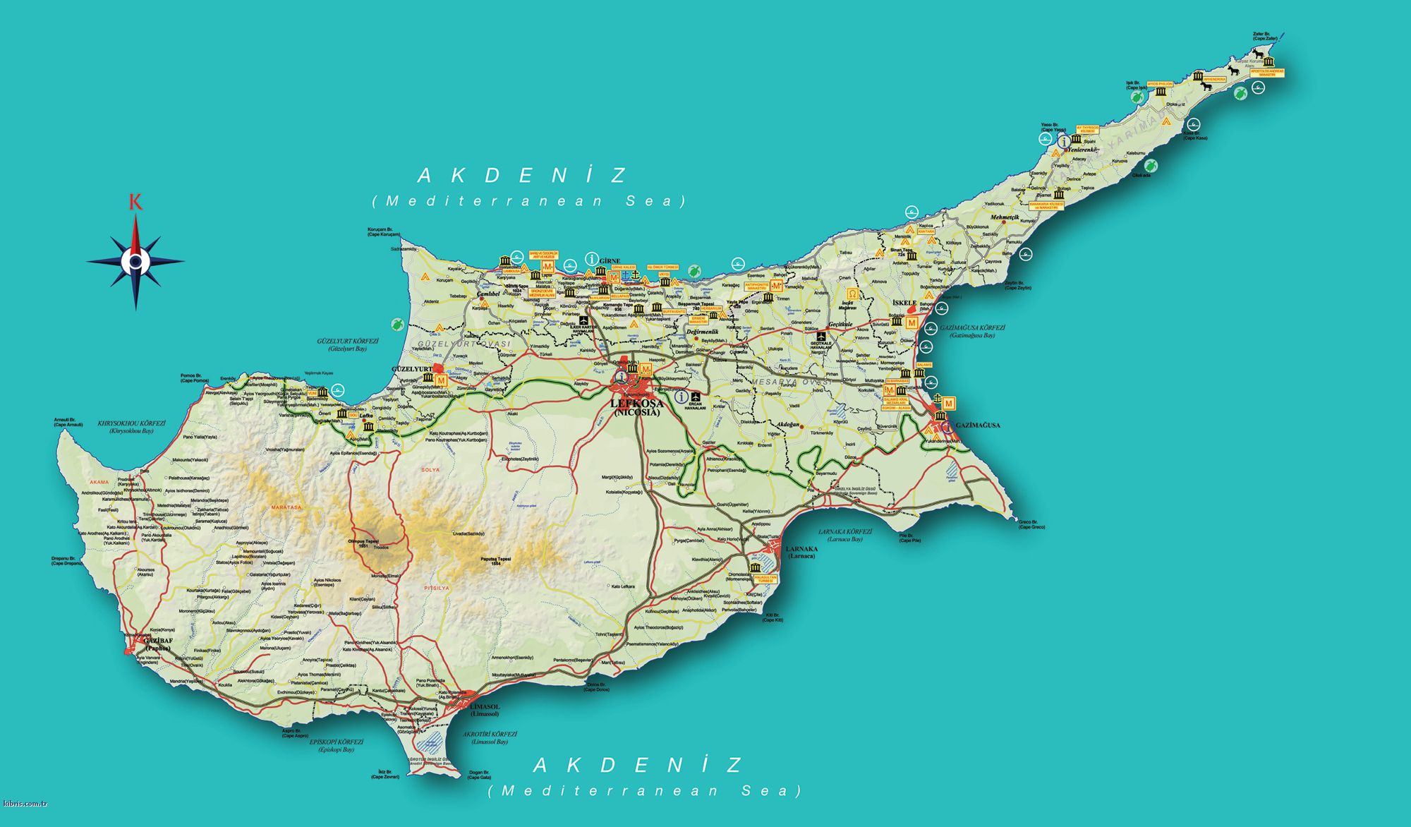
| Description | Map of the districts of Cyprus, with English annotations, and showing the Turkish Republic of Northern Cyprus, United Kingdom Sovereign Base Areas, and United Nations buffer zone. The TRNC section illustrates the current de facto district boundaries following this map as a guide. The northern districts are labelled in Turkish. | |||
| Date | (UTC) | |||
| Source | ||||
| Author |
|
|||
| Other versions |
|


I, the copyright holder of this work, hereby publish it under the following licenses:
This file is licensed under the Creative Commons Attribution-Share Alike 2.5 Generic, 2.0 Generic and 1.0 Generic license.
- You are free:
- to share – to copy, distribute and transmit the work
- to remix – to adapt the work
- Under the following conditions:
- attribution – You must give appropriate credit, provide a link to the license, and indicate if changes were made. You may do so in any reasonable manner, but not in any way that suggests the licensor endorses you or your use.
- share alike – If you remix, transform, or build upon the material, you must distribute your contributions under the same or compatible license as the original.

|
Permission is granted to copy, distribute and/or modify this document under the terms of the GNU Free Documentation License, Version 1.2 or any later version published by the Free Software Foundation; with no Invariant Sections, no Front-Cover Texts, and no Back-Cover Texts. A copy of the license is included in the section entitled GNU Free Documentation License. |
| This file is licensed under the Creative Commons Attribution-Share Alike 3.0 Unported license. | ||
| ||
| This licensing tag was added to this file as part of the GFDL licensing update. |
You may select the license of your choice.
Original upload log
[edit]
This image is a derivative work of the following images:
- Image:Cyprus_districts_named.png licensed with Cc-by-sa-2.5,2.0,1.0, GFDL
- 2007-08-13T14:28:15Z Lexicon 600x365 (22511 Bytes) Reverted to earlier revision
- 2007-08-13T14:28:03Z Lexicon 600x365 (55202 Bytes) buffer zone and SBA colours flipped, since buffer zone is called the "Green Line"
- 2005-06-30T06:07:58Z Golbez 600x365 (22511 Bytes) Got Dhekelia wrong again. Final version unless others have comments.
- 2005-06-28T02:04:32Z Golbez 600x365 (22795 Bytes) Updated again, final version for now, cleaned up text and the Dhekelia area.
- 2005-06-27T17:51:02Z Golbez 600x365 (20527 Bytes) Fixed a color
- 2005-06-27T17:44:36Z Golbez 600x365 (20529 Bytes) Updated map with different color for north and south, and enclaves in Dhekelia.
- 2005-06-27T09:48:54Z Golbez 600x365 (19121 Bytes) Map of the districts of [[Cyprus]] Source: Made by [[User:Golbez]]. {{cc-by-sa-2.0}} [[Category:Maps of Cyprus]]\
Uploaded with derivativeFX
File history
Click on a date/time to view the file as it appeared at that time.
| Date/Time | Thumbnail | Dimensions | User | Comment | |
|---|---|---|---|---|---|
| current | 13:34, 18 September 2008 | | 600 × 365 (47 KB) | QuartierLatin1968 (talk | contribs) | {{Information |Description=Map of the districts of Cyprus, with English annotations, and showing the Turkish Republic of Northern Cyprus, United Kingdom Sovereign Base Areas, and United Nations buffer zone. The TRNC section illustrates the current ''de fa |
You cannot overwrite this file.
File usage on Commons
The following 3 pages use this file:
File usage on other wikis
The following other wikis use this file:
- Usage on am.wikipedia.org
- Usage on ar.wikipedia.org
- Usage on arz.wikipedia.org
- Usage on ba.wikipedia.org
- Usage on be.wikipedia.org
- Usage on bg.wikipedia.org
- Usage on de.wikipedia.org
- Usage on el.wikipedia.org
- Usage on en.wikipedia.org
- Usage on fr.wikipedia.org
- Usage on gl.wikipedia.org
- Usage on it.wikivoyage.org
- Usage on la.wikipedia.org
- Usage on mk.wikipedia.org
- Usage on mrj.wikipedia.org
- Usage on pt.wikipedia.org
- Usage on ru.wikipedia.org
- Usage on sc.wikipedia.org
- Usage on simple.wikipedia.org
- Usage on sk.wikipedia.org
- Usage on sr.wikipedia.org
- Usage on sv.wikipedia.org
- Usage on tg.wikipedia.org
- Usage on tr.wikipedia.org
- Usage on uk.wikipedia.org
- Usage on vi.wikipedia.org
- Usage on zh.wikipedia.org