File:MS Nordnorge, Hurtigruten in Raftsundet, Nordland, Norway, 2015 September.jpg
Jump to navigation
Jump to search

Size of this preview: 800 × 258 pixels. Other resolutions: 320 × 103 pixels | 640 × 206 pixels | 1,024 × 330 pixels | 1,280 × 412 pixels | 6,000 × 1,933 pixels.
Original file (6,000 × 1,933 pixels, file size: 7.46 MB, MIME type: image/jpeg)
Captions
Captions
Add a one-line explanation of what this file represents
Summary
[edit]
| Description |
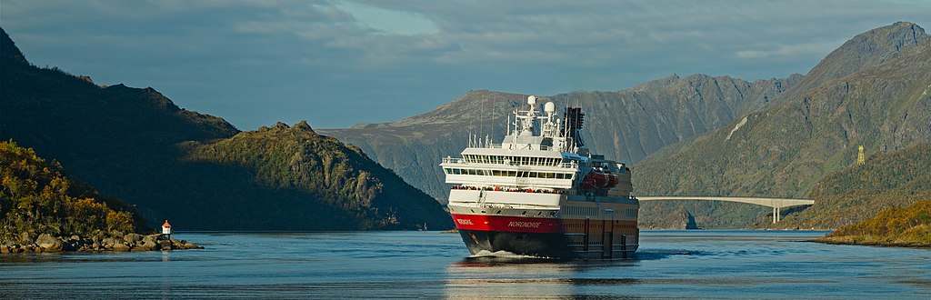
English: Hurtigruten ship MS Nordnorge in Raftsundet, Hadsel municipality, Nordland, Norway in 2015 September. Raftsundet is a strait between the islands of Hinnøya and Austvågøya at the foot of Lofoten archipelago.
Español: MS Nordnorge, un barco Hurtigruten navegando por el estrecho de Raftsundet, cerca de Hadsel, Nordland, Noruega en septiembre de 2015. El estrecho de Raftsundet se extiende entre las islas de Hinnøya y Austvågøya, al pie de las montañas de las islas Lofoten.
Polski: Należący do linii Hurtigruten prom MS Nordnorge w cieśninie Raftsundet w gminie Hadsel, w okręgu Nordland, w Norwegii. Raftsundet jest cieśniną pomiędzy wyspami Hinnøya i Austvågøy, u stóp archipelagu Lofotów.
Українська: Корабель «Нурнорге» пливе протокою Рафтсуннет біля міста Гадсель, Нурланн, Норвегія. Протока Рафтсуннет протікає між островами Гіннея та Еуствогей, які є частиною архіпелагу Лофотен.
Čeština: Jedna z lodí systému Hurtigruten - MS Nordnorge v úžině Raftsundet mezi ostrovy Hinnøya a Austvågøy v souostroví Lofoty, Norsko, září 2015.
Magyar: A Hurtigruten hajója, az MS Nordnorge a Raftsundet-szorosban, Hadsel településnél 2015 szeptemberében (Nordland megye, Norvégia)
Italiano: La nave MS Nordnorge, del servizio norvegese Hurtigruten, nel Raftsundet, comune di Hadsel, contea di Nordland, Norvegia nel settembre 2015. Raftsundet è uno stretto tra le isole di Hinnøya e Austvågøy dell'arcipelago delle Lofoten.
한국어: 2015년 가을, 노르웨이 노를란 주 핫셀 지방의 라프트순데를 지나는 후르티그루텐 사(社)의 MS 노르드노르게. 라프트순데는 로포텐 제도 가장자리의 한뇌위아 섬과 아우스트보괴위 섬 사이의 해협이다.
Nederlands: MS Nordnorge, een schip van Hurtigruten, vaart door de Raftsundet. Deze zeestraat scheidt de Noorse eilanden Hinnøya en Austvågøya.
Português: MS Nordnorge, um dos 14 navios que fazem parte da linha marítima Hurtigruten navegando pelo estreito de Raftsundet, próximo de Hadsel, condado de Nordland, Noruega. |
| Date | |
| Source | Own work |
| Author | Ximonic (Simo Räsänen) |
| Camera location | | View this and other nearby images on: OpenStreetMap |
|---|

|
NOTE: This image is a panorama consisting of multiple frames that were merged or stitched in software using a cylindrical projection. As a result, this image necessarily underwent some form of digital manipulation. These manipulations may include blending, blurring, cloning, and colour and perspective adjustments. As a result of these adjustments, the image content may be slightly different from reality at the points where multiple images were combined. This manipulation is often required due to lens, perspective, and parallax distortions.
|
Assessment
[edit]
|
This image was selected as picture of the day on Wikimedia Commons for 28 October 2017. It was captioned as follows: English: Hurtigruten ship MS Nordnorge in Raftsundet, Hadsel municipality, Nordland, Norway in 2015 September. Raftsundet is a strait between the islands of Hinnøya and Austvågøya at the foot of Lofoten archipelago. Other languages:
Čeština: Jedna z lodí systému Hurtigruten - MS Nordnorge v úžině Raftsundet mezi ostrovy Hinnøya a Austvågøy v souostroví Lofoty, Norsko, září 2015. English: Hurtigruten ship MS Nordnorge in Raftsundet, Hadsel municipality, Nordland, Norway in 2015 September. Raftsundet is a strait between the islands of Hinnøya and Austvågøya at the foot of Lofoten archipelago. Español: MS Nordnorge, un barco Hurtigruten navegando por el estrecho de Raftsundet, cerca de Hadsel, Nordland, Noruega en septiembre de 2015. El estrecho de Raftsundet se extiende entre las islas de Hinnøya y Austvågøya, al pie de las montañas de las islas Lofoten. Italiano: La nave MS Nordnorge, del servizio norvegese Hurtigruten, nel Raftsundet, comune di Hadsel, contea di Nordland, Norvegia nel settembre 2015. Raftsundet è uno stretto tra le isole di Hinnøya e Austvågøy dell'arcipelago delle Lofoten. Magyar: A Hurtigruten hajója, az MS Nordnorge a Raftsundet-szorosban, Hadsel településnél 2015 szeptemberében (Nordland megye, Norvégia) Nederlands: MS Nordnorge, een schip van Hurtigruten, vaart door de Raftsundet. Deze zeestraat scheidt de Noorse eilanden Hinnøya en Austvågøya. Polski: Należący do linii Hurtigruten prom MS Nordnorge w cieśninie Raftsundet w gminie Hadsel, w okręgu Nordland, w Norwegii. Raftsundet jest cieśniną pomiędzy wyspami Hinnøya i Austvågøy, u stóp archipelagu Lofotów. Português: MS Nordnorge, um dos 14 navios que fazem parte da linha marítima Hurtigruten navegando pelo estreito de Raftsundet, próximo de Hadsel, condado de Nordland, Noruega. Українська: Корабель «Норднорге» пливе протокою Рафтсундет біля міста Хадсель, Нурлан, Норвегія. Протока Рафтсундет протікає між островами Хінньоя та Еуствогьой, які є частиною архіпелагу Лофотен. |
Licensing
[edit]
This file is licensed under the Creative Commons Attribution-Share Alike 3.0 Unported license.
- You are free:
- to share – to copy, distribute and transmit the work
- to remix – to adapt the work
- Under the following conditions:
- attribution – You must give appropriate credit, provide a link to the license, and indicate if changes were made. You may do so in any reasonable manner, but not in any way that suggests the licensor endorses you or your use.
- share alike – If you remix, transform, or build upon the material, you must distribute your contributions under the same or compatible license as the original.
| Annotations | This image is annotated: View the annotations at Commons |
File history
Click on a date/time to view the file as it appeared at that time.
| Date/Time | Thumbnail | Dimensions | User | Comment | |
|---|---|---|---|---|---|
| current | 15:22, 2 December 2015 | 6,000 × 1,933 (7.46 MB) | Ximonic (talk | contribs) | VicuñaUploader 1.20 |
You cannot overwrite this file.
File usage on Commons
The following 32 pages use this file:
- User:Julian Herzog/Favorites
- User:Meiræ/15
- User:OgreBot/Watercraft/2015 December 1-4
- User:Pechristener/Bridges/2015 December 1-10
- User:Ximonic/Gallery/Norway/Nordland
- User talk:Ximonic/Archive/2015
- Commons:Featured picture candidates/File:MS Nordnorge, Hurtigruten in Raftsundet, Nordland, Norway, 2015 September.jpg
- Commons:Featured picture candidates/Log/December 2015
- Commons:Featured pictures/Objects/Vehicles/Water transport
- Commons:Featured pictures/chronological/2015-B
- Commons:Picture of the Year/2015/Candidates
- Commons:Picture of the Year/2015/R1/Gallery/2014-B
- Commons:Picture of the Year/2015/R1/Gallery/2015-B
- Commons:Picture of the Year/2015/R1/Gallery/ALL
- Commons:Picture of the Year/2015/R1/Gallery/M12
- Commons:Picture of the Year/2015/R1/Gallery/Vehicles and crafts
- Commons:Picture of the Year/2015/R1/v/MS Nordnorge, Hurtigruten in Raftsundet, Nordland, Norway, 2015 September.jpg
- Commons:Quality images/Subject/Places/Mixed/Panorama/Archive 2008 to 2015
- Commons:Quality images candidates/Archives December 06 2015
- Template:Potd/2017-10
- Template:Potd/2017-10-28
- Template:Potd/2017-10-28 (cs)
- Template:Potd/2017-10-28 (en)
- Template:Potd/2017-10-28 (es)
- Template:Potd/2017-10-28 (hu)
- Template:Potd/2017-10-28 (it)
- Template:Potd/2017-10-28 (ko)
- Template:Potd/2017-10-28 (mk)
- Template:Potd/2017-10-28 (nl)
- Template:Potd/2017-10-28 (pl)
- Template:Potd/2017-10-28 (pt)
- Template:Potd/2017-10-28 (uk)
File usage on other wikis
The following other wikis use this file:
- Usage on av.wikipedia.org
- Usage on be-tarask.wikipedia.org
- Usage on crh.wikipedia.org
- Usage on cv.wikipedia.org
- Usage on fi.wikipedia.org
- Usage on hu.wikipedia.org
- Usage on hy.wikipedia.org
- Usage on ka.wikipedia.org
- Usage on ko.wikipedia.org
- Usage on krc.wikipedia.org
- Usage on lbe.wikipedia.org
- Usage on lez.wikipedia.org
- Usage on mdf.wikipedia.org
- Usage on mk.wikipedia.org
- Usage on no.wikipedia.org
- Usage on os.wikipedia.org
- Usage on pt.wikipedia.org
- Usage on ru.wikipedia.org
- Usage on ru.wikinews.org
- Usage on sah.wikipedia.org
- Usage on tr.wikipedia.org
- Usage on tt.wikipedia.org
- Usage on tyv.wikipedia.org
- Usage on udm.wikipedia.org
- Usage on uk.wikipedia.org
- Usage on vep.wikipedia.org
- Usage on vi.wikipedia.org
- Usage on xal.wikipedia.org
- Usage on zh.wikipedia.org