File:Duchy of Courland & Semigallia 1740.svg
Jump to navigation
Jump to search

Size of this PNG preview of this SVG file: 681 × 599 pixels. Other resolutions: 273 × 240 pixels | 546 × 480 pixels | 873 × 768 pixels | 1,164 × 1,024 pixels | 2,328 × 2,048 pixels | 1,074 × 945 pixels.
Original file (SVG file, nominally 1,074 × 945 pixels, file size: 510 KB)
Captions
Captions
Add a one-line explanation of what this file represents
Summary
[edit]| Description |
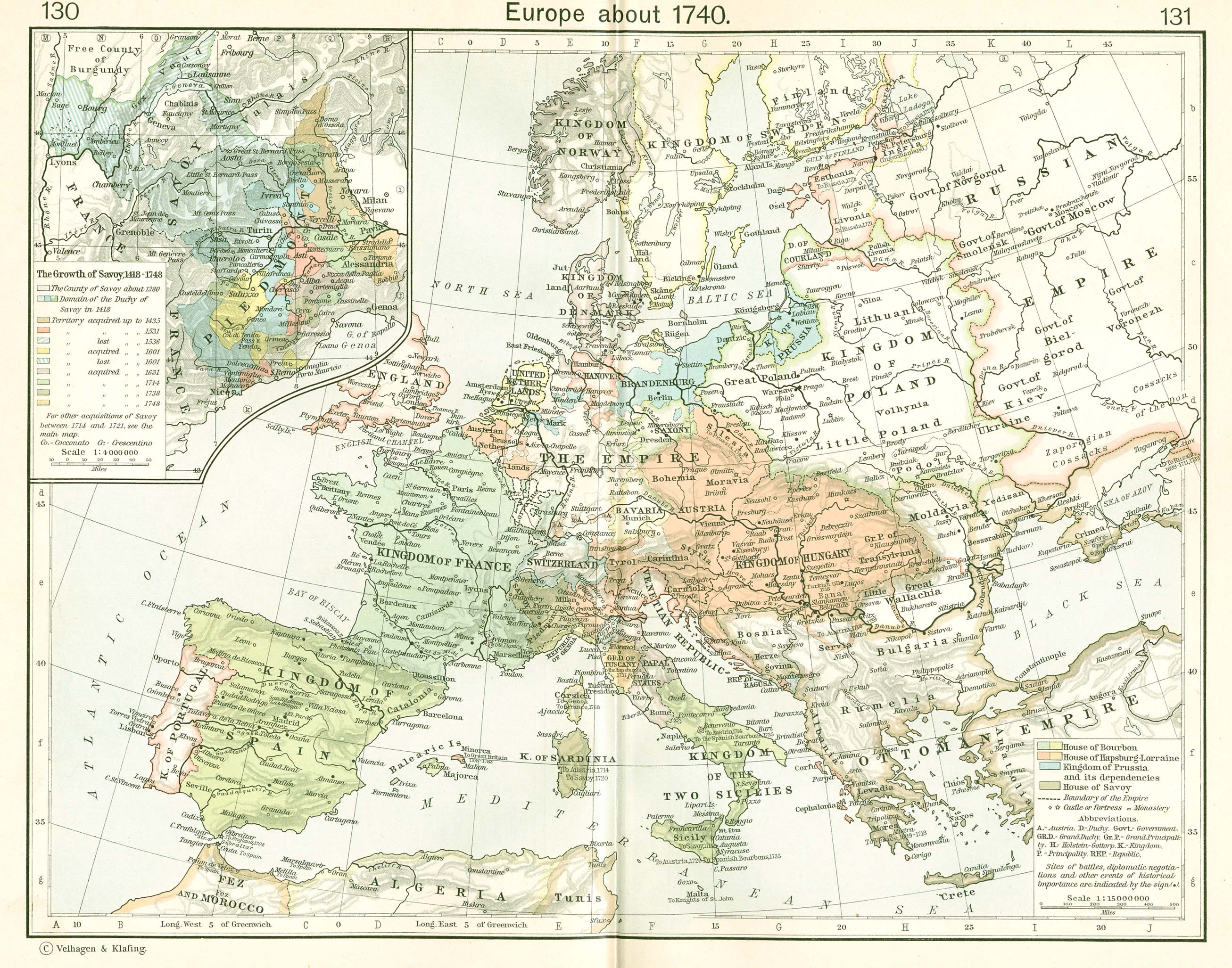
Latviešu: Kurzemes un Zemgales Hercogiste 1740.
Français : Le duché de Courlande et Sémigalie en 1740.
English: The Duchy of Courland and Semigallia in 1740.
Polski: Księstwo Kurlandii i Semigalii w 1740 roku.
The towns and cities are designated by their German names since the nobility and the Duke were of German heritage. The rivers, somewhat incongruously, are given their common Latvian names. This map uses a Mercator projection. |
| Date | 21 January 2007 (original upload date) |
| Source | No machine-readable source provided. Own work assumed (based on copyright claims). |
| Author | No machine-readable author provided. MapMaster assumed (based on copyright claims). |
| Other versions |
|


References
[edit]
The basic map was developed from Shepherd:
- Shepherd, William R., (1911), "Europe, 1740" in Historical Atlas, p. 131.
Modifications were made based on other resources including:
- Hammond Historical World Atlas, Hammond World Atlas Corporation, (2000).
Other versions
[edit]
Licensing
[edit]
I, the copyright holder of this work, hereby publish it under the following license:

|
Permission is granted to copy, distribute and/or modify this document under the terms of the GNU Free Documentation License, Version 1.2 or any later version published by the Free Software Foundation; with no Invariant Sections, no Front-Cover Texts, and no Back-Cover Texts. A copy of the license is included in the section entitled GNU Free Documentation License. |
| This file is licensed under the Creative Commons Attribution-Share Alike 3.0 Unported license. | ||
| ||
| This licensing tag was added to this file as part of the GFDL licensing update. |
File history
Click on a date/time to view the file as it appeared at that time.
| Date/Time | Thumbnail | Dimensions | User | Comment | |
|---|---|---|---|---|---|
| current | 17:27, 24 January 2007 | | 1,074 × 945 (510 KB) | MapMaster (talk | contribs) | upgraded |
| 01:55, 24 January 2007 |  | 1,074 × 945 (510 KB) | MapMaster (talk | contribs) | made some improvements based on feedback from our Lithuanian editors | |
| 15:16, 21 January 2007 |  | 1,074 × 945 (498 KB) | MapMaster (talk | contribs) | A map of the Duchy of Courland and Semigallia in 1740 |
You cannot overwrite this file.
File usage on Commons
The following 6 pages use this file:
File usage on other wikis
The following other wikis use this file:
- Usage on ar.wikipedia.org
- Usage on be-tarask.wikipedia.org
- Usage on be.wikipedia.org
- Usage on bg.wikipedia.org
- Usage on br.wikipedia.org
- Usage on ca.wikipedia.org
- Usage on cs.wikipedia.org
- Usage on da.wikipedia.org
- Usage on de.wikipedia.org
- Usage on el.wikipedia.org
- Usage on en.wikipedia.org
- Usage on eo.wikipedia.org
- Usage on et.wikipedia.org
- Usage on fi.wikipedia.org
- Usage on fr.wikipedia.org
- Usage on he.wikipedia.org
- Usage on hr.wikipedia.org
- Usage on hy.wikipedia.org
- Usage on id.wikipedia.org
- Usage on is.wikipedia.org
- Usage on it.wikipedia.org
- Usage on ja.wikipedia.org
- Usage on ko.wikipedia.org
- Usage on lt.wikipedia.org
- Usage on nn.wikipedia.org
- Usage on pl.wikipedia.org
- Usage on pl.wiktionary.org
- Usage on pt.wikipedia.org
- Usage on ro.wikipedia.org
- Usage on ru.wikipedia.org
- Usage on sh.wikipedia.org
- Usage on simple.wikipedia.org
- Usage on sl.wikipedia.org
- Usage on sr.wikipedia.org
- Usage on sv.wikipedia.org
View more global usage of this file.