Commons:Featured picture candidates/File:Tornadic Debris lofted over 30,000 feet.jpg
Jump to navigation
Jump to search

File:Tornadic Debris lofted over 30,000 feet.jpg, not featured[edit]
Voting period is over. Please don't add any new votes.Voting period ends on 10 Sep 2023 at 05:57:45 (UTC)
Visit the nomination page to add or modify image notes.

- Gallery: Commons:Featured pictures/Non-photographic media/Computer-generated#Other
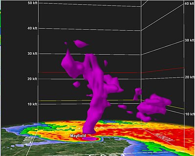
 Info created by the National Weather Service - uploaded by Highteeld99 - nominated by WeatherWriter -- Additional information: Radar depiction of debris being thrown 30,000 feet (9,100 m) was reported by media outlets.[1][2], confirming the radar model’s factual accuracy. WeatherWriter (talk) 05:57, 1 September 2023 (UTC)
 Support -- Factually accurate modeling from a National Weather Service NEXRAD radar during the 2021 Western Kentucky tornado. This is a support from me as it seems as good as the only other tornado radar-related featured picture File:05june-dow7-wide.gif. WeatherWriter (talk) 05:57, 1 September 2023 (UTC)
 Question How is it possible that there are gaps in the debris field? Can you reference the source material for this image? Needs date/time to be specified. Charlesjsharp (talk) 07:53, 1 September 2023 (UTC)
 Comment Tornadoes don’t produce just a straight “wall of debris”, so air gaps are created as debris is thrown up and out. The tornado entered the town of Mayfield at 9:26 p.m. CST (03:26 UTC) on December 10, 2021 (so radar imagery used would have been within a few minutes of that), and this data would have been from the KPAH NEXRAD radar owned by the National Weather Service. Sources stating that debris was thrown 30,000 feet are listed above in the info section, which included one from NBC News, where they stated, “One such indicator was debris lofted high into the air. Radar suggested that the Mayfield tornado threw debris over 30,000 feet into the air. That's the altitude commercial airplanes fly.” Should note that the data is from the National Weather Service. WeatherWriter (talk) 14:29, 1 September 2023 (UTC)
- Perhaps the density/density gradient (with a scale) of the debris in different parts of the sky might be helpful. It is not convincing as illustrated. Minor quibbles: there are unmarked yellow and red lines and the white Kft lines have inconsistent thickness. Charlesjsharp (talk) 15:57, 1 September 2023 (UTC)
- This internet page may be rubbish, but the timing (after the tornado hit?) and analysis (not all debris?) make me wonder. Charlesjsharp (talk) 16:11, 1 September 2023 (UTC)
- Perhaps the density/density gradient (with a scale) of the debris in different parts of the sky might be helpful. It is not convincing as illustrated. Minor quibbles: there are unmarked yellow and red lines and the white Kft lines have inconsistent thickness. Charlesjsharp (talk) 15:57, 1 September 2023 (UTC)
- Comment Small for an FP but would be a great VI if nominated at COM:VIC. -- Ikan Kekek (talk) 01:39, 6 September 2023 (UTC)
Confirmed results:
Result: 1 support, 0 oppose, 0 neutral → not featured. /-- Radomianin (talk) 14:38, 6 September 2023 (UTC)