File:World Health Organisation regional offices.PNG
Jump to navigation
Jump to search

Size of this preview: 800 × 370 pixels. Other resolutions: 320 × 148 pixels | 640 × 296 pixels | 1,357 × 628 pixels.
Original file (1,357 × 628 pixels, file size: 36 KB, MIME type: image/png)
Captions
Captions
Add a one-line explanation of what this file represents

|
File:World Health Organisation regional offices.svg is a vector version of this file. It should be used in place of this PNG file when not inferior.
File:World Health Organisation regional offices.PNG → File:World Health Organisation regional offices.svg
For more information, see Help:SVG. |
 |
Summary[edit]
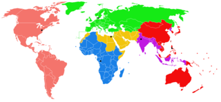
Map of World Health Organisation regional offices. Regional office HQ marked with a black square.
- Blue = Regional Office for Africa (AFRO)I, with headquarters in Brazzaville, Republic of Congo.
- Green = Regional Office for Europe (EURO), with headquarters in Copenhagen, Denmark.
- Purple = Regional Office for South East Asia (SEARO), with headquarters in New Delhi, India. North Korea is served by SEARO.
- Yellow = Regional Office for the Eastern Mediterranean (EMRO), with headquarters in Cairo, Egypt.
- Red = Regional Office for Western Pacific (WPRO), with headquarters in Manila, Philippines.
- Pink = Regional Office for the Americas (AMRO), with headquarters in Washington, DC, United States of America. It is better known as the Pan American Health Organization, or PAHO.
Sample image definition[edit]

Regional offices and regions of the WHO:
Africa; HQ: Brazzaville, Congo
Europe; HQ: Copenhagen, Denmark
Western Pacific; HQ: Manila, Philippines
Licensing[edit]

|
Permission is granted to copy, distribute and/or modify this document under the terms of the GNU Free Documentation License, Version 1.2 or any later version published by the Free Software Foundation; with no Invariant Sections, no Front-Cover Texts, and no Back-Cover Texts. A copy of the license is included in the section entitled GNU Free Documentation License. |
| This file is licensed under the Creative Commons Attribution-Share Alike 3.0 Unported license. | ||
| ||
| This licensing tag was added to this file as part of the GFDL licensing update. |
File history
Click on a date/time to view the file as it appeared at that time.
| Date/Time | Thumbnail | Dimensions | User | Comment | |
|---|---|---|---|---|---|
| current | 15:47, 10 March 2018 | | 1,357 × 628 (36 KB) | Maphobbyist (talk | contribs) | South Sudan border |
| 07:22, 28 April 2009 |  | 1,357 × 628 (47 KB) | IJA (talk | contribs) | Fixed boarders for BiH, Croatia, Armenia, Azerbaijan, Gaza, Israel. Semi coloured in Taiwan as the UN recognises PRChina sovereignty over it. Semi coloured in Western Sahara. I also coloured in Greenland as green because it is a part of Denmark and Denmar | |
| 19:02, 25 July 2006 |  | 1,357 × 628 (47 KB) | Satesclop (talk | contribs) | ||
| 19:01, 25 July 2006 |  | 1,357 × 628 (47 KB) | Satesclop (talk | contribs) | ||
| 10:57, 10 April 2006 |  | 1,357 × 628 (47 KB) | Roke~commonswiki (talk | contribs) | Map of World Health Organisation regional offices. Regional office HQ marked with a black square. Category: United Nations |
You cannot overwrite this file.
File usage on Commons
The following 3 pages use this file:
File usage on other wikis
The following other wikis use this file:
- Usage on cs.wikipedia.org
- Usage on en.wikipedia.org
- Usage on fr.wikipedia.org