File:Tz-map.png
Jump to navigation
Jump to search
No higher resolution available.
Tz-map.png (256 × 274 pixels, file size: 32 KB, MIME type: image/png)
Captions
Captions
Add a one-line explanation of what this file represents
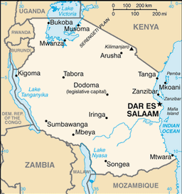
CIA map of Tanzania
This image is in the public domain because it contains materials that originally came from the United States Central Intelligence Agency's World Factbook.
|
 |
File history
Click on a date/time to view the file as it appeared at that time.
| Date/Time | Thumbnail | Dimensions | User | Comment | |
|---|---|---|---|---|---|
| current | 19:59, 8 September 2012 | | 256 × 274 (32 KB) | Thricecube (talk | contribs) | Updated version of the map. |
| 23:14, 4 March 2005 |  | 330 × 351 (14 KB) | Alfio (talk | contribs) | CIA map of Tanzania |
You cannot overwrite this file.
File usage on Commons
The following 4 pages use this file:
File usage on other wikis
The following other wikis use this file:
- Usage on an.wikipedia.org
- Usage on be-tarask.wikipedia.org
- Usage on bjn.wikipedia.org
- Usage on bn.wikipedia.org
- Usage on br.wikipedia.org
- Usage on cs.wikipedia.org
- Usage on da.wikipedia.org
- Usage on de.wikipedia.org
- Usage on en.wikipedia.org
- Usage on es.wikipedia.org
- Usage on fi.wikipedia.org
- Usage on fr.wikipedia.org
- Usage on fy.wikipedia.org
- Usage on he.wikipedia.org
- Usage on hu.wikipedia.org
- Usage on hu.wiktionary.org
- Usage on id.wikipedia.org
- Usage on io.wikipedia.org
- Usage on is.wikipedia.org
- Usage on it.wikipedia.org
- Usage on ja.wikipedia.org
- Usage on kg.wikipedia.org
- Usage on ln.wikipedia.org
- Usage on mi.wikipedia.org
- Usage on nds.wikipedia.org
- Usage on nl.wiktionary.org
- Usage on nn.wikipedia.org
- Usage on pl.wikivoyage.org
- Usage on pt.wikipedia.org
- Usage on ro.wikipedia.org
- Usage on scn.wikipedia.org
View more global usage of this file.