File:Swat NWFP.svg
Jump to navigation
Jump to search

Size of this PNG preview of this SVG file: 558 × 600 pixels. Other resolutions: 223 × 240 pixels | 446 × 480 pixels | 714 × 768 pixels | 953 × 1,024 pixels | 1,905 × 2,048 pixels | 1,000 × 1,075 pixels.
Original file (SVG file, nominally 1,000 × 1,075 pixels, file size: 202 KB)
Captions
Captions
Add a one-line explanation of what this file represents
Summary[edit]
| Description |
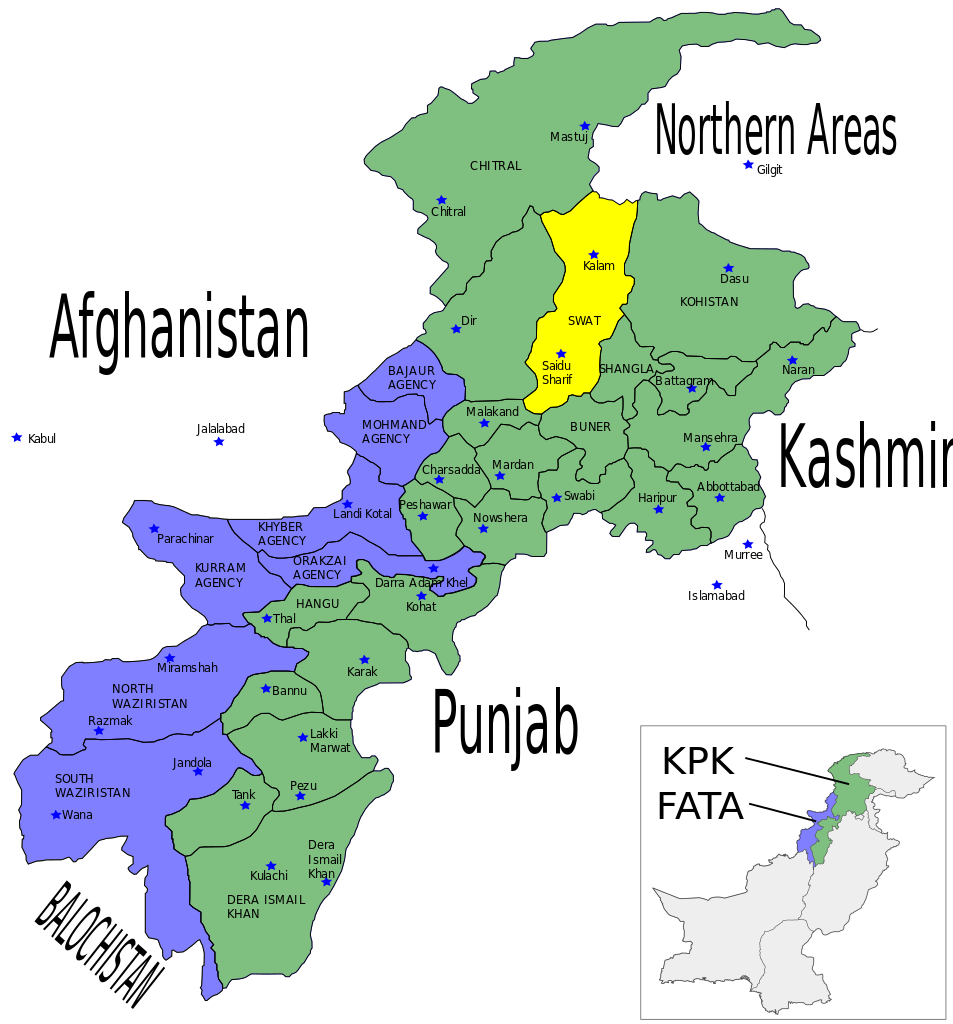
English: Map showing the location of Swat District (highlighted in yellow) within the Khyber-Pakhtunkhwa Province of Pakistan. |
| Date | |
| Source | Self made using Inkscape - Based on maps from http://www.nwfp.gov.pk |
| Author | Pahari Sahib |
| Other versions | Derivative works of this file: NWPF-Pakistan.png |
Licensing[edit]
I, Pahari Sahib, the copyright holder of this work, hereby publishes it under the following licenses:

|
Permission is granted to copy, distribute and/or modify this document under the terms of the GNU Free Documentation License, Version 1.2 or any later version published by the Free Software Foundation; with no Invariant Sections, no Front-Cover Texts, and no Back-Cover Texts. A copy of the license is included in the section entitled GNU Free Documentation License. |
| This file is licensed under the Creative Commons Attribution-Share Alike 3.0 Unported license. | ||
| Attribution: I, Pahari Sahib | ||
| ||
| This licensing tag was added to this file as part of the GFDL licensing update. |
This file is licensed under the Creative Commons Attribution-Share Alike 2.5 Generic, 2.0 Generic and 1.0 Generic license.
Attribution: I, Pahari Sahib
- You are free:
- to share – to copy, distribute and transmit the work
- to remix – to adapt the work
- Under the following conditions:
- attribution – You must give appropriate credit, provide a link to the license, and indicate if changes were made. You may do so in any reasonable manner, but not in any way that suggests the licensor endorses you or your use.
- share alike – If you remix, transform, or build upon the material, you must distribute your contributions under the same or compatible license as the original.
You may select the license of your choice.
File history
Click on a date/time to view the file as it appeared at that time.
| Date/Time | Thumbnail | Dimensions | User | Comment | |
|---|---|---|---|---|---|
| current | 23:54, 16 May 2010 | | 1,000 × 1,075 (202 KB) | Guillaume70 (talk | contribs) | New version : map showing Pakistan + NWPF => PKP Category:SVG maps of Pakistan |
| 04:03, 12 June 2007 |  | 1,000 × 1,075 (171 KB) | Pahari Sahib (talk | contribs) | {{Information |Description=Map showing the location of Swat District (highlighted in yellow) within the North-West Frontier Province (NWFP) of Pakistan. |Source=Self made using Inkscape - Based on maps from http://www.nwfp.gov.pk |Date=12/06/07 |A |
You cannot overwrite this file.
File usage on Commons
The following 2 pages use this file:
File usage on other wikis
The following other wikis use this file:
- Usage on da.wikipedia.org
- Usage on fr.wikipedia.org
- Usage on nl.wikipedia.org
- Usage on no.wikipedia.org
- Usage on pnb.wikipedia.org
- Usage on www.wikidata.org