File:San Jose-San Francisco-Oakland CSA.svg

From Wikimedia Commons, the free media repository
Jump to navigation Jump to search

Original file(SVG file, nominally 621 × 733 pixels, file size: 255 KB)

Captions

Captions

Add a one-line explanation of what this file represents
Description
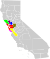
English: Locator map of the San Jose-San Francisco-Oakland Combined Statistical Area in the western part of the U.S. state of California. The six components of the CSA are colored separately:
  •  
    Red - San Francisco-Oakland-Fremont Metropolitan Statistical Area
  •  
    Yellow - San Jose-Sunnyvale-Santa Clara Metropolitan Statistical Area
  •  
    Light Green - Santa Rosa-Petaluma Metropolitan Statistical Area
  •  
    Dark Blue - Vallejo-Fairfield Metropolitan Statistical Area
  •  
    Brown - Santa Cruz-Watsonville Metropolitan Statistical Area
  •  
    Purple - Napa Metropolitan Statistical Area
  •  
    Olive - Stockton Metropolitan Statistical Area
  •  
    Light Blue - Modesto Metropolitan Statistical Area
  •  
    Dark Green - Merced Metropolitan Statistical Area
Date
Source

Based on File:San Jose-San Francisco-Oakland CSA.png Reverified from US Census

Original was "Modified from this United States Census Bureau file, based on the following Census definitions lists:

Author User:Optigan13
Permission
(Reusing this file)
Public domain I, the copyright holder of this work, release this work into the public domain. This applies worldwide.
In some countries this may not be legally possible; if so:
I grant anyone the right to use this work for any purpose, without any conditions, unless such conditions are required by law.
Other versions File:San Jose-San Francisco-Oakland CSA.png
 
W3C-validity not checked.

File history

Click on a date/time to view the file as it appeared at that time.

Date/TimeThumbnailDimensionsUserComment
current22:21, 25 April 2019Thumbnail for version as of 22:21, 25 April 2019621 × 733 (255 KB)DBaron (talk | contribs)add Stanislaus and Merced counties to match OMB Bulletin 2018-04, and adjust colors for better contrast
19:00, 27 August 2013Thumbnail for version as of 19:00, 27 August 2013621 × 733 (255 KB)Optigan13 (talk | contribs)Fixed ID to remove spaces id="San_Jose-San_Francisco-Oakland_CSA"
18:57, 27 August 2013Thumbnail for version as of 18:57, 27 August 2013621 × 733 (255 KB)Optigan13 (talk | contribs)Removed sodipodi attributes in file to allow for svg validation Changed Santa Cruz's purple to #800080 Changed San Joaquin from Spring Green to Olive
18:38, 6 August 2013Thumbnail for version as of 18:38, 6 August 2013621 × 733 (258 KB)Optigan13 (talk | contribs)Added San Joaquin county per page 109 of http://www.whitehouse.gov/sites/default/files/omb/bulletins/2013/b13-01.pdf
23:59, 28 May 2009Thumbnail for version as of 23:59, 28 May 2009621 × 733 (257 KB)Optigan13 (talk | contribs){{Information |Description={{en|Locator map of the {{w|San Francisco Bay Area|San Jose-San Francisco-Oakland}} {{w|Combined Statistical Area}} in the western part of the U.S. state of California. The six components of the CSA are colored separately: * {{l

The following 2 pages use this file:

File usage on other wikis

Metadata