File:Sacramento watershed.png
Jump to navigation
Jump to search
No higher resolution available.
Sacramento_watershed.png (288 × 307 pixels, file size: 39 KB, MIME type: image/png)
Captions
Captions
Add a one-line explanation of what this file represents
Summary[edit]
| Description |
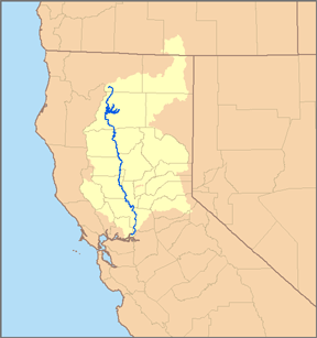
This is a map of the Sacramento River watershed — in Northern California. I, Pfly, made it, based on USGS data. |
| Date | |
| Source | Own work |
| Author | Pfly |
Licensing[edit]
I, the copyright holder of this work, hereby publish it under the following license:
This file is licensed under the Creative Commons Attribution-Share Alike 2.5 Generic license.
- You are free:
- to share – to copy, distribute and transmit the work
- to remix – to adapt the work
- Under the following conditions:
- attribution – You must give appropriate credit, provide a link to the license, and indicate if changes were made. You may do so in any reasonable manner, but not in any way that suggests the licensor endorses you or your use.
- share alike – If you remix, transform, or build upon the material, you must distribute your contributions under the same or compatible license as the original.
File history
Click on a date/time to view the file as it appeared at that time.
| Date/Time | Thumbnail | Dimensions | User | Comment | |
|---|---|---|---|---|---|
| current | 00:46, 3 May 2007 | | 288 × 307 (39 KB) | DanMS (talk | contribs) | Trimmed excess white space around image and uploaded same again. |
| 06:53, 6 January 2007 |  | 300 × 319 (56 KB) | Pfly (talk | contribs) | {{Information |Description=This is a map of the Sacramento River watershed. I, Pfly, made it, based on USGS data. |Source=Own work. |Date=January 5, 2007 |Author=Pfly |Permission= |other_versions= }} |
You cannot overwrite this file.
File usage on Commons
The following 3 pages use this file:
File usage on other wikis
The following other wikis use this file:
- Usage on bg.wikipedia.org
- Usage on de.wikipedia.org
- Usage on de.wikinews.org
- Usage on es.wikipedia.org
- Usage on et.wikipedia.org
- Usage on fr.wikipedia.org
- Usage on hu.wikipedia.org
- Usage on it.wikipedia.org
- Usage on ko.wikipedia.org
- Usage on li.wikipedia.org
- Usage on nl.wikipedia.org
- Usage on no.wikipedia.org
- Usage on ro.wikipedia.org
- Usage on sw.wikipedia.org
- Usage on vi.wikipedia.org
- Usage on www.wikidata.org