File:Official LanguagesMap-Africa.png
Jump to navigation
Jump to search
No higher resolution available.
Official_LanguagesMap-Africa.png (360 × 392 pixels, file size: 21 KB, MIME type: image/png)
Captions
Captions
Add a one-line explanation of what this file represents

|
File:Official LanguagesMap-Africa.svg is a vector version of this file. It should be used in place of this PNG file when not inferior.
File:Official LanguagesMap-Africa.png → File:Official LanguagesMap-Africa.svg
For more information, see Help:SVG. |
 |
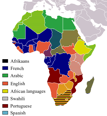
Taken from Image:BlankMap-Africa.png. Information from http://www.nationsonline.org/oneworld/index.html and CIA World Factbook
| I, the copyright holder of this work, release this work into the public domain. This applies worldwide. In some countries this may not be legally possible; if so: I grant anyone the right to use this work for any purpose, without any conditions, unless such conditions are required by law. |
Other version[edit]
-
 Afrikaans
 -
 Français


File history
Click on a date/time to view the file as it appeared at that time.
| Date/Time | Thumbnail | Dimensions | User | Comment | |
|---|---|---|---|---|---|
| current | 18:05, 16 March 2018 | | 360 × 392 (21 KB) | Maphobbyist (talk | contribs) | Updates |
| 12:54, 6 May 2008 |  | 746 × 813 (250 KB) | Ant75 (talk | contribs) | Updated Madagascar to English, French and Traditional African following 2007 Constitution. | |
| 12:54, 1 May 2008 |  | 720 × 784 (186 KB) | Ant75 (talk | contribs) | Updated Sudan to English and Arabic following 2005 Constitution. | |
| 19:59, 16 March 2007 |  | 360 × 392 (14 KB) | Rasulo~commonswiki (talk | contribs) | Updated earlier version due to officialization of Swahili in Uganda. Also corrected the language status of Zimbabwe where Shona and Ndebele are currently co-official with English. | |
| 17:05, 19 May 2005 |  | 360 × 392 (14 KB) | Rydia~commonswiki (talk | contribs) | Taken from Image:BlankMap-Africa.png. Information from http://www.nationsonline.org/oneworld/index.html and CIA World Factbook {{PD}} |
You cannot overwrite this file.
File usage on Commons
The following 2 pages use this file:
File usage on other wikis
The following other wikis use this file:
- Usage on ca.wikipedia.org
- Usage on de.wikipedia.org
- Usage on he.wikivoyage.org
- Usage on kg.wikipedia.org
- Usage on oc.wikipedia.org
- Usage on pam.wikipedia.org
- Usage on ss.wikipedia.org