File:H1N1 map.svg
Jump to navigation
Jump to search

Size of this PNG preview of this SVG file: 800 × 406 pixels. Other resolutions: 320 × 162 pixels | 640 × 325 pixels | 1,024 × 520 pixels | 1,280 × 650 pixels | 2,560 × 1,299 pixels | 940 × 477 pixels.
Original file (SVG file, nominally 940 × 477 pixels, file size: 1.28 MB)
Captions
Captions
Add a one-line explanation of what this file represents
Summary[edit]
| Description |
Azərbaycanca: 2009-cu ildə H1N1 virusu aşkarlanmış ölkələrin xəritəsi.
dəqiqləşmiş ölüm və infeksiya hadisələri
dəqiqləşmiş infeksiya hadisələri
dəqiq olmayan infeksiya hadisələri
Vəziyyət davamlı olaraq dəyişdiyi üçün xəritə tez-tez yenilənə bilər.
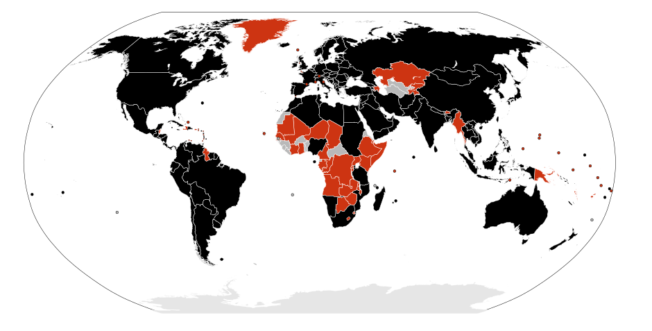
English: A map of the infected countries of the H1N1 flu of 2009.
confirmed death and infections
confirmed infections
unconfirmed infections
The map can be edited very rapidly because it is a current event which is changing hour by hour.
Español: Mapa de los países afectados por la pandemia de influenza H1N1 de 2009.
muertes confirmadas
infecciones confirmadas
infecciones no confirmadas
Este mapa puede cambiar muy rápidamente, dado que es un evento actual que cambia hora a hora.
العربية: خريطة البلدان المصابة وباء الإنفلونزا A/H1N1 عام 2009.
إصابات ووفيات مؤكدة
إصابات مؤكدة
إصابات غير مؤكدة
يمكن أن تتغير هذه الخريطة بسرعة لأنها تعكس أحداثاً جارية.
Català: Mapa dels països afectats por la pandèmia d'influència H1N1 del 2009.
morts confirmades
infeccions confirmades
infeccions no confirmades
Aquest mapa pot canviar molt ràpidament, ja que és un esdeveniment actual que canvia hora a hora.
Čeština: Mapa s případy prasečí chřipky (viru H1N1) v roce 2009.
potvrzené úmrtí nakaženého
potvrzené nakažení
podezření na nakažení
Mapa znázorňuje aktuální stav probíhající události, může se proto rychle měnit.
Dansk: Et kort over ramte lande med H1N1 influenzaen i 2009.
bekræftet med dødsfald
bekræftet
ubekræftet
Dette kort kan hurtigt blive redigeret fordi det er en aktuel begivenhed der skifter fra time til time.
Deutsch: Karte der betroffenen Staaten der H1N1 Influenza Epidemie 2009.
bestätigte Todesfälle
bestätigte Infektionen
unbestätigte Infektionen
Diese Karte unterliegt häufigen Änderungen, da sich der derzeitige Status stündlich ändern kann. Als Referenz dient diese Tabelle
Nederlands: Kaart met de getroffen landen door het H1N1 Influenza Epidemie 2009.
Bevestigde overlijdensgevallen
Bevestigde gevallen
Onbevestigde gevallen
Deze kaart is onderhevig aan frequente wijzigingen, omdat de situatie zich per uur kan wijzigen. Als referentie dient Tabel
Eesti: 2009. aasta gripi H1N1 pandeemiast haaratud riikide kaart.
kinnitatud surmajuhtumid
kinnitatud haigusjuhtumid
kinnitamata haigusjuhtumid
See kaart võib sageli muutuda, sest kõnealune olukord muutub kiiresti.
Euskara: 2009n H1N1 gripe epidemiaz kutsatutako estatuen mapa.
ziurtatutako heriotzak
ziurtatutako kasuak
ziurtatu gabeko kasuak
Mapa hau une batetik bestera alda daiteke, momentu honetan jazotzen ari den gertakaria delako.
Suomi: Kartta H1N1-influenssan levinneisyydestä vuonna 2009.
vahvistettuja tartuntoja ja kuolemia
vahvistettuja tartuntoja
vahvistamattomia tartuntoja
Kuvaa saatetaan päivittää usein, koska kyseessä on nopeasti etenevä ajankohtainen tilanne.
Français : Une carte des pays infectés par l'épidémie de grippe H1N1 de 2009.
morts confirmées
infections confirmées
infections non confirmées
Cette carte peut évoluer très rapidement, car il s'agit d'un événement en cours.
Galego: Mapa dos paises afectados pola epidemia de influenza H1N1 de 2009.
mortes confirmadas
infeccións confirmadas
infeccións non confirmadas
Este mapa pode mudar moi rápidamente, xa que é un acontecimento actual que muda hora a hora.
Ελληνικά: Χάρτης με τις χώρες που εμφανίστηκε ο ιός H1N1 του 2009.
επιβεβαιωμένοι θάνατοι και μολύνσεις
επιβεβαιωμένες μολύνσεις
μη επιβεβαωμένες μολύνσεις
Ο χάρτης διαμορφώνεται γρήγορα γιατί τα γεγονότα αλλάζουν από ώρα σε ώρα.
עברית: מפה של המדינות הנגועות בשפעת H1N1 של 2009
מקרי מוות ודאיים מהנגיף
מקרי הידבקות וודאים מהנגיף
חשד למקרי הידבקות מהנגיף
המפה יכולה להתעדכן בתדירות גבוהה משום שהנתונים בה משתנים על בסיס יומי.
Hrvatski: Mapa s prikazom država zaraženih svinjskom gripom 2009.
Potvrđena smrt/potvrđene smrti i zaraze
Potvrđene zaraze
Suspektne/nepotvrđene zaraze
Ova se mapa može vrlo često mijenjati budući da se radi o događaju u tijeku koji se mijenja iz sata u sat
Interlingua: Un mappa del paises infectate del grippe H1N1 de 2009.
mortes confirmate e infectiones
infectiones confirmate
infectiones non confirmate
Le mappa pote esser modificate multo rapidemente proque illo es un evento currente que cambia hora a hora. Pro editar le imagine, usa un editor de texto pro adder le codice de pais ISO 316601 alpha-2 appropriate al region de definition CSS (vicin supra).
Italiano: Una mappa dei paesi colpiti dall'epidemia dell'influenza suina H1N1 nel 2009.
morti confermati
infezioni confermate
infezioni non confermate
Questa mappa può mutare molto rapidamente poiché si tratta di un evento in corso.
ქართული: H1N1 ვირუსით დაავადებული ქვეყნების რუკა 2009 წლისთვის.
დაინფიცირების დადასტურებული შემთხვევები, რომელიც სიკვდილით დასრულდა
დაინფიცირების დადასტურებული შემთხვევები
დაინფიცირების დაუდასტურებული შემთხვევები
რუკა შეიძლება შეიცვალოს ძალიან ხშირად, რადგან ის ეხება ამჟამად მიმდინარე მოვლენებს, რომლებიც შეიძლება ყოველ საათში შეიცვალოს.
Română: Harta ţărilor infectate cu virusul H1N1 al gripei porcine din 2009.
cazuri confirmate de infecţie urmate de moarte
cazuri confirmate de infecţie
cazrui neconfirmate de infecţie
Această hartă poate fi editată foarte frecvent deoarece se referă la un eveniment curent care se schimbă din oră în oră.
日本語: 2009年豚インフルエンザの集団発生状況
死亡者が確認された国・地域
感染者が確認された国・地域
感染の疑いのある者が存在する国・地域
状況が刻一刻と変化するため、この地図は頻繁に更新されます。
Lietuvių: H1N1 gripu infekuotų šalių žemėlapis 2009m.
patvirtintos mirtys ir susirgimai
patvirtinti susirgimai
nepatvirtinti susirgimai
Žemėlapis gali būti labai sparčiai redaguojamas, nes tai yra šiuo metu vykstantis įvykis, besikeičiantis valandų bėgyje.
한국어: 지도의 색칠된 부분은 2009년 돼지 인플루엔자 사태의 피해정도를 나타낸다.
감염 환자 확인 및 사망자 발생
감염 환자 확인
감염 의심 환자 발생
실제 통계는 상당히 빠르게 변화하고 있으므로 지도의 정보는 오래되었을 수도 있습니다.
Nederlands: Een kaart die de landen met besmette mensen aangeeft met het H1N1 griep.
bevestigde doden
bevestigde gevallen
onbevestigde gevallen
De kaart verandert erg vaak omdat de kaart een overzicht is van een actuele gebeurtenis.
Norsk bokmål: Et kart over land rammet av H1N1-influensaen i 2009.
bekreftet dødsfall
bekreftet
ubekreftet
Dette kartet kan raskt endres fordi det er en aktuell hendelse som endres fra time til time.
Polski: Mapa prezentująca infekcje wirusem H1N1.
potwierdzone zgony
potwierdzone infekcje
niepotwierdzone infekcje
Mapa jest nieustannie aktualizowana.
Português: Mapa de países infectados pela epidemia da gripe A (H1N1) de 2009.
mortes confirmadas
infecções confirmadas
infecções não confirmadas
Este mapa pode mudar muito rapidamente, pois trata-se dum acontecimento atual.
Română: Harta ţărilor infectate cu virusul H1N1 al gripei porcine din 2009.
cazuri confirmate de infecţii şi decese
cazuri confirmate de infecţii
cazuri neconfirmate de infecţii
Această hartă se poate modifica frecvent deoarece se referă la un eveniment curent care se poate schimba din oră în oră.
Русский: Карта заражённых гриппом H1N1 стран в 2009 году.
подтверждённые случаи заражения, закончившиеся смертью
подтверждённые случаи заражения
неподтверждённые случаи заражения
Карта может меняться очень часто, так как относится к текущим событиям, которые меняются каждый час.
Shqip: Harta e vendeve të goditura nga gripi H1N1 në 2009.
raste të konfirmuara vdekjesh dhe infektimi
raste të konfirmuara infektimi
raste infektimi të pakonfirmuara
Harta mund të ndryshojë shumë shpesh sepse është një ngjarje aktuale dhe mund të identifikohen raste të reja.
Slovenčina: Mapa s prípadmi novej (prasacej) chrípky (vírus H1N1) v roku 2009.
potvrdené úmrtie nakazeného
potvrdené nakazenie
podozrenie na nakazenie
Mapa znázorňuje aktuálny stav prebiehajúcej udalosti, môže sa preto rýchle zmeniť.
Српски / srpski: Мапа држава у којима су забележени случајеви свињског грипа узрокованог H1N1 вирусом.
потврђене заразе и смртни случајеви
потврђени случајеви заразе
непотврђени случајеви заразе
Могуће су честе измене мапе јер она прати актуелни догађај, који се мења из сата у сат.
Svenska: Karta av de länder som blivit drabbade av den nya H1N1 influensan 2009.
bekräftade dödsfall
bekräftade infektioner
obekräftade infektioner
Denna karta kan komma att ändras ofta, för referens, se denna tabell
Türkçe: 2009 yılı içinde H1N1 virüsünden etkilenen ülkelerin haritası.
kesinleşmiş ölüm ve enfeksiyon vakaları
kesinleşmiş enfeksiyon vakaları
kesin olmayan enfeksiyon vakaları
Durum sürekli değişiklik gösterdiği için harita çok sık olarak değiştirilebilir.
中文(中国大陆):2009年H1N1流感已传播地区状况图
有死亡病例的国家或地区
有确认感染病例,但尚无死亡病例的国家或地区
有疑似已感染患者,但尚无确认感染病例的国家或地区
传播状况可能随时间改变,这个地图会因此而频繁更新。
中文(香港):2009年H1N1流感已傳播地區狀況圖
已有死亡案例的國家或地區
已有確認感染案例的國家或地區
有疑似已感染患者, 但尚未有確認個案的國家或地區
傳播狀況可能隨時有變, 這個地圖會因此而需要頻繁更改
Editor CommentsTo edit the image file, use a text editor to add appropriate ISO 3166-1 alpha-2 country codes to the CSS definitions region of image file (near the top). |
| Date | |
| Source |
Own work (Original text: Own work by uploader, used File:BlankMap-World6, compact.svg as original template.) |
| Author | Allstrak |
| Other versions |
Derivative works of this file: H1N1 map-2009-07-11.svg
|
| SVG development | This W3C-invalid map was created with Adobe Illustrator, and with Inkscape. |


Licensing[edit]
'Allstrak, the copyright holder of this work, hereby publishes it under the following licenses:

|
Permission is granted to copy, distribute and/or modify this document under the terms of the GNU Free Documentation License, Version 1.2 or any later version published by the Free Software Foundation; with no Invariant Sections, no Front-Cover Texts, and no Back-Cover Texts. A copy of the license is included in the section entitled GNU Free Documentation License. |
This file is licensed under the Creative Commons Attribution-Share Alike 4.0 International, 3.0 Unported, 2.5 Generic, 2.0 Generic and 1.0 Generic license.
Attribution: 'Allstrak
- You are free:
- to share – to copy, distribute and transmit the work
- to remix – to adapt the work
- Under the following conditions:
- attribution – You must give appropriate credit, provide a link to the license, and indicate if changes were made. You may do so in any reasonable manner, but not in any way that suggests the licensor endorses you or your use.
- share alike – If you remix, transform, or build upon the material, you must distribute your contributions under the same or compatible license as the original.
You may select the license of your choice.
File history
Click on a date/time to view the file as it appeared at that time.
| Date/Time | Thumbnail | Dimensions | User | Comment | |
|---|---|---|---|---|---|
| current | 01:38, 1 March 2010 | | 940 × 477 (1.28 MB) | Fonadier (talk | contribs) | Updating to February 28, 2010 |
| 02:30, 1 February 2010 |  | 940 × 477 (1.28 MB) | Fonadier (talk | contribs) | Updating to January 31, 2010 | |
| 14:25, 19 January 2010 |  | 940 × 477 (1.23 MB) | Hariboneagle927 (talk | contribs) | first case in Mali | |
| 02:58, 12 January 2010 |  | 940 × 477 (1.28 MB) | Fonadier (talk | contribs) | Updating to January 11, 2010 | |
| 02:41, 21 December 2009 |  | 940 × 477 (1.28 MB) | Fonadier (talk | contribs) | Updating to December 20, 2009 | |
| 03:00, 7 December 2009 |  | 940 × 477 (1.28 MB) | Fonadier (talk | contribs) | Updating to December 6, 2009 | |
| 02:50, 30 November 2009 |  | 940 × 477 (1.28 MB) | Fonadier (talk | contribs) | Updated to November 29, 2009 | |
| 12:07, 26 November 2009 |  | 940 × 477 (1.28 MB) | KlaudiuMihaila (talk | contribs) | Romania has deceased cases. | |
| 01:35, 24 November 2009 |  | 940 × 477 (1.28 MB) | Fonadier (talk | contribs) | Fixing map | |
| 02:24, 23 November 2009 |  | 940 × 477 (1.28 MB) | Fonadier (talk | contribs) | Updated to November 22, 2009 |
You cannot overwrite this file.
File usage on Commons
The following 9 pages use this file:
- 2009 swine flu outbreak
- User:Frettiebot/Galleries/Jklamo/2009/10
- User:Frettiebot/Galleries/Jklamo/2009/11
- User:Frettiebot/Galleries/Jklamo/2009/4
- User:Frettiebot/Galleries/Jklamo/2009/5
- File:H1N1 map-2009-07-11.svg
- File:H1N1 map by confirmed cases.svg
- File:H1N1 map by confirmed deaths.svg
- File:H1N1 map by total cases.svg
File usage on other wikis
The following other wikis use this file:
- Usage on af.wikipedia.org
- Usage on ar.wikipedia.org
- Usage on arz.wikipedia.org
- Usage on az.wikipedia.org
- Usage on bat-smg.wikipedia.org
- Usage on bg.wikipedia.org
- Usage on bn.wikipedia.org
- Usage on ca.wikipedia.org
- Usage on cs.wikipedia.org
- Usage on cy.wikipedia.org
- Usage on da.wikipedia.org
- Usage on de.wikipedia.org
- Usage on el.wikipedia.org
- Usage on en.wikipedia.org
- User:Download/Adopt/Ross Rhodes
- File talk:H1N1 map.svg
- 2009 swine flu pandemic by country
- Talk:2009 swine flu pandemic by country summary/Archive 1
- Talk:Swine influenza/Archive 2
- Talk:2009 swine flu pandemic by country summary/Archive 2
- File talk:H1N1 map by confirmed cases.svg
- Talk:2009 swine flu pandemic/Archive 6
- File talk:H1N1 map by confirmed deaths.svg
- File talk:H1N1 map by total cases.svg
- Wikipedia:Graphics Lab/Map workshop/Archive/Jun 2009
- Talk:2009 swine flu pandemic in Asia
- Talk:2009 swine flu pandemic by country/Archive 2
- Talk:2009 swine flu pandemic/Archive 7
- File talk:H1N1 map by confirmed community outbreaks.svg
- Wikipedia:Graphics Lab/Map workshop/Archive/Jul 2009
- 2009 flu pandemic table April 2009
- User talk:Its snowing in East Asia/Archive 2
- Usage on en.wikinews.org
- Usage on eo.wikipedia.org
- Usage on es.wikipedia.org
View more global usage of this file.