File:Gulf of Aden map.png
Jump to navigation
Jump to search
Size of this preview: 719 × 600 pixels. Other resolutions: 288 × 240 pixels | 575 × 480 pixels | 921 × 768 pixels | 1,227 × 1,024 pixels | 2,500 × 2,086 pixels.
Original file (2,500 × 2,086 pixels, file size: 765 KB, MIME type: image/png)
Captions
Captions
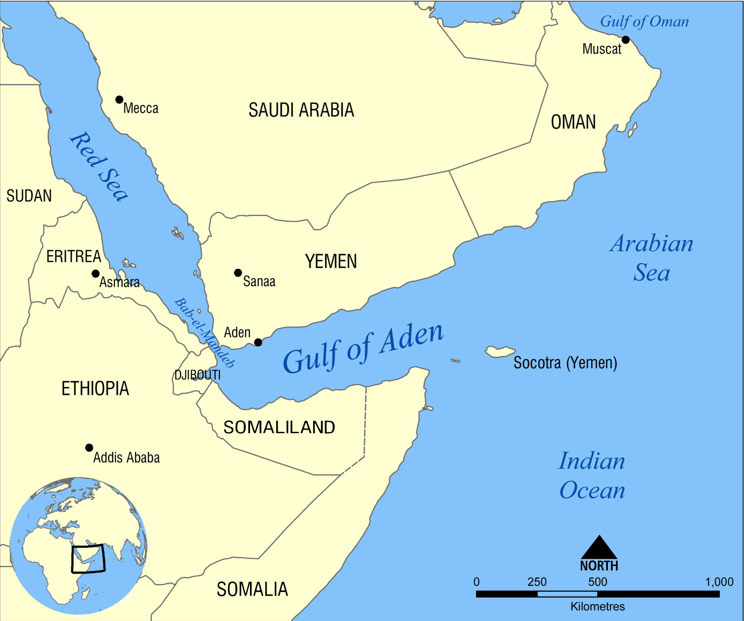
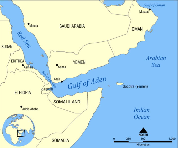
Location of the Gulf of Aden
Summary[edit]
| Description |
Eesti: Adeni lahe kaart English: Map showing the location of the Gulf of Aden, located between Yemen and Somalia. Nearby bodies of water include the Indian Ocean, Red Sea, Arabian Sea, and the Bab-el-Mandeb Strait. Español: Golfo de Adén, localizado en el Mar arábigo, entre Yemén y Somalia (o Somalilandia). Hrvatski: Adenski zaljev Қазақша: Аден шығанағының орналасуын көрсететін қазақтілді карта. Русский: Карта на казахском языке, показывающяя местоположение Аденского залива. العربية : خريطة تُبيِّن موقع خليج عدن بين اليمن والصومال. المُسطحات المائيَّة المُجاورة هي: المُحيط الهندي والبحر الأحمر وبحر العرب ومضيق باب المندب. |
||
| Date | |||
| Source | Own work | ||
| Author | NormanEinstein | ||
| Other versions |
[]
|


Licensing[edit]
I, the copyright holder of this work, hereby publish it under the following licenses:
This file is licensed under the Creative Commons Attribution-Share Alike 3.0 Unported license.
- You are free:
- to share – to copy, distribute and transmit the work
- to remix – to adapt the work
- Under the following conditions:
- attribution – You must give appropriate credit, provide a link to the license, and indicate if changes were made. You may do so in any reasonable manner, but not in any way that suggests the licensor endorses you or your use.
- share alike – If you remix, transform, or build upon the material, you must distribute your contributions under the same or compatible license as the original.

|
Permission is granted to copy, distribute and/or modify this document under the terms of the GNU Free Documentation License, Version 1.2 or any later version published by the Free Software Foundation; with no Invariant Sections, no Front-Cover Texts, and no Back-Cover Texts. A copy of the license is included in the section entitled GNU Free Documentation License. |
You may select the license of your choice.
File history
Click on a date/time to view the file as it appeared at that time.
| Date/Time | Thumbnail | Dimensions | User | Comment | |
|---|---|---|---|---|---|
| current | 04:57, 28 December 2023 | | 2,500 × 2,086 (765 KB) | Subayerboombastic (talk | contribs) | Reverted to version as of 14:50, 25 December 2023 (UTC) |
| 21:36, 27 December 2023 |  | 841 × 703 (134 KB) | SawsanJojo (talk | contribs) | Reverted to version as of 07:20, 5 November 2023 (UTC) | |
| 14:50, 25 December 2023 |  | 2,500 × 2,086 (765 KB) | Jacob300 (talk | contribs) | Reverted to version as of 21:19, 2 November 2023 (UTC) | |
| 07:20, 5 November 2023 |  | 841 × 703 (134 KB) | Salma3232 (talk | contribs) | Reverted to version as of 17:50, 29 September 2023 (UTC) | |
| 21:19, 2 November 2023 |  | 2,500 × 2,086 (765 KB) | Jacob300 (talk | contribs) | Reverted to version as of 12:14, 22 October 2022 (UTC) | |
| 17:50, 29 September 2023 |  | 841 × 703 (134 KB) | Seemsrathytaway (talk | contribs) | update control https://www.blackagendareport.com/blue-flag-over-las-anod-victory-somali-nationalists | |
| 12:14, 22 October 2022 |  | 2,500 × 2,086 (765 KB) | Jacob300 (talk | contribs) | Reverted to version as of 15:14, 13 October 2021 (UTC) | |
| 17:44, 7 September 2022 |  | 2,500 × 2,086 (204 KB) | Anwar8989 (talk | contribs) | Reverted to version as of 18:22, 29 January 2009 (UTC) | |
| 15:14, 13 October 2021 |  | 2,500 × 2,086 (765 KB) | Gebagebo (talk | contribs) | fixed Somaliland's eastern border | |
| 17:35, 13 May 2021 |  | 2,500 × 2,086 (763 KB) | Jacob300 (talk | contribs) | Added Somaliland to map. |
You cannot overwrite this file.
File usage on Commons
The following 7 pages use this file:
File usage on other wikis
The following other wikis use this file:
- Usage on af.wikipedia.org
- Usage on ar.wikipedia.org
- Usage on ast.wikipedia.org
- Usage on az.wikipedia.org
- Usage on bn.wikipedia.org
- Usage on bs.wikipedia.org
- Usage on ca.wikipedia.org
- Usage on ce.wikipedia.org
- Usage on cs.wikipedia.org
- Usage on el.wikipedia.org
- Usage on en.wikipedia.org
- Usage on en.wikinews.org
- Usage on eo.wikipedia.org
- Usage on es.wikipedia.org
- Usage on eu.wikipedia.org
- Usage on fa.wikipedia.org
- Usage on fi.wikipedia.org
- Usage on fr.wikipedia.org
- Usage on gl.wikipedia.org
- Usage on gu.wikipedia.org
- Usage on he.wikipedia.org
- Usage on hu.wikipedia.org
- Usage on hy.wikipedia.org
- Usage on id.wikipedia.org
- Usage on ilo.wikipedia.org
- Usage on it.wikipedia.org
- Usage on ja.wikipedia.org
- Usage on ka.wikipedia.org
- Usage on kcg.wikipedia.org
View more global usage of this file.