File:Gaza conflict map.png
Jump to navigation
Jump to search
No higher resolution available.
Gaza_conflict_map.png (612 × 300 pixels, file size: 27 KB, MIME type: image/png)
Captions
Captions
Add a one-line explanation of what this file represents
Summary[edit]
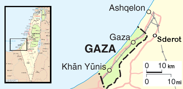
| Description | Map of the conflict area around the Gaza strip |
| Date | |
| Source | self-made, from this PD image |
| Author | Orlovic |
Licensing[edit]
| I, the copyright holder of this work, release this work into the public domain. This applies worldwide. In some countries this may not be legally possible; if so: I grant anyone the right to use this work for any purpose, without any conditions, unless such conditions are required by law. |
File history
Click on a date/time to view the file as it appeared at that time.
| Date/Time | Thumbnail | Dimensions | User | Comment | |
|---|---|---|---|---|---|
| current | 10:23, 12 April 2009 | | 612 × 300 (27 KB) | Ogre (talk | contribs) | removed border as per request |
| 12:35, 22 December 2008 |  | 627 × 315 (32 KB) | Orlovic (talk | contribs) | == Summary == {{Information |Description=Map of the conflict area around the Gaza strip |Source=self-made, from this PD image |Date=May 2007 |Author= Orlovic }} == Licensing == {{PD-se | |
| 20:45, 22 May 2007 |  | 627 × 315 (32 KB) | Orlovic (talk | contribs) | {{Information |Description=Map of the conflict area around the Gaza strip |Source=self-made, from this PD image |Date=May 2007 |Author= Orlovic }} Category:Maps of Israel |
You cannot overwrite this file.
File usage on Commons
There are no pages that use this file.
File usage on other wikis
The following other wikis use this file:
- Usage on ar.wikipedia.org
- Usage on br.wikipedia.org
- Usage on ckb.wikipedia.org
- Usage on cs.wikipedia.org
- Usage on cs.wikinews.org
- Usage on cy.wikipedia.org
- Usage on da.wikipedia.org
- Usage on de.wikipedia.org
- Usage on de.wikinews.org
- Usage on en.wikipedia.org
- Usage on en.wikinews.org
- Usage on es.wikipedia.org
- Usage on es.wikinews.org
- Usage on eu.wikipedia.org
- Usage on fa.wikipedia.org
- Usage on fr.wikipedia.org
- Usage on he.wikipedia.org
- Usage on hu.wikipedia.org
- Usage on id.wikipedia.org
- Usage on it.wikipedia.org
- Usage on it.wikinews.org
- Israele: raid aerei in risposta ai razzi. Hamas: la tregua per noi è finita
- Israele: raid su Jabalia. Hamas contatta Hezbollah
- Israele: politica richiede una "difesa attiva" per destituire Hamas
- Striscia di Gaza: iniziata l'offensiva israeliana
- Striscia di Gaza: Israele prepara l'assalto via terra. ANP pronto a riprendere il controllo dell'area
- Striscia di Gaza: 400 morti. Voci di una tregua, poi Hamas smentisce
- Striscia di Gaza: Israele lancia volantini. Centrale nucleare a rischio razzi
- Striscia di Gaza: Israele inizia l'offensiva via terra
- Striscia di Gaza: terzo giorno di offensiva terrestre israeliana. Razzi a 40 km da Tel Aviv
- Striscia di Gaza: tregua umanitaria di tre ore. Olmert blocca la «terza fase»
- Template:Operazione Piombo fuso
- Striscia di Gaza: colpita sede Unrwa. Per l'Egitto la tregua è vicina
- Striscia di Gaza: Israele dichiara tregua unilaterale. Hamas: «Per noi non conta»
View more global usage of this file.