File:California Interstate 15.svg
Jump to navigation
Jump to search

Size of this PNG preview of this SVG file: 800 × 444 pixels. Other resolutions: 320 × 178 pixels | 640 × 356 pixels | 1,024 × 569 pixels | 1,280 × 711 pixels | 2,560 × 1,422 pixels | 1,152 × 640 pixels.
Original file (SVG file, nominally 1,152 × 640 pixels, file size: 736 KB)
Captions
Captions
Add a one-line explanation of what this file represents
Summary[edit]
| Description |
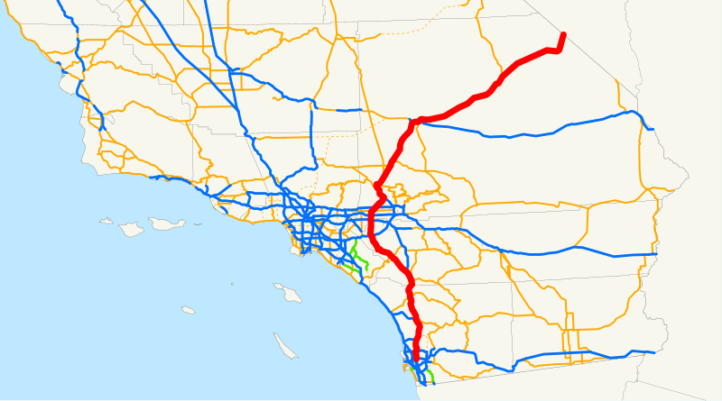
English: This is a map of Interstate 15 in California, with unconstructed parts in purple. |
| Source | Email me if you would like a copy of the GIS data I created for the highways. |
| Author | User:NE2 |
Sources: BTS North American Transportation Atlas Data archive copy at the Wayback Machine, Caltrans State Truck Route List (XLS file), Caltrans Log of Bridges on State Highways, All Caltrans Traffic Volumes on CSHS, California State Legislature Definitions of Routes
Licensing[edit]
| I, the copyright holder of this work, release this work into the public domain. This applies worldwide. In some countries this may not be legally possible; if so: I grant anyone the right to use this work for any purpose, without any conditions, unless such conditions are required by law. |
File history
Click on a date/time to view the file as it appeared at that time.
| Date/Time | Thumbnail | Dimensions | User | Comment | |
|---|---|---|---|---|---|
| current | 13:33, 18 December 2007 | | 1,152 × 640 (736 KB) | NE2 (talk | contribs) | == Summary == This is a map of Interstate 15 in California, with unconstructed parts in purple. Email me if you would like a copy of the GIS data I created for the highways. Category:Interstate 15 in California [[Category:Ma |
You cannot overwrite this file.
File usage on Commons
The following 2 pages use this file:
File usage on other wikis
The following other wikis use this file:
- Usage on es.wikipedia.org
- Usage on ru.wikipedia.org
- Usage on www.wikidata.org