File:Alps satellite in winter.jpg

Original file (2,400 × 1,800 pixels, file size: 1.33 MB, MIME type: image/jpeg)
Captions
Captions
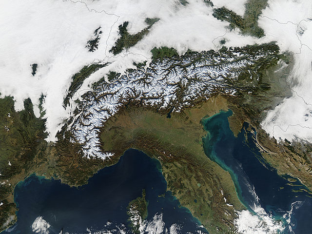
en: Heralding the oncoming winter, snow dusts the peaks of the Alps in this true-color Terra MODIS image from December 11, 2004. North of the Alps, clouds cover France, Switzerland, Liechtenstein, Austria, and Slovenia. South of the Alps, clear skies dominate most of the image, leaving the Po River valley and peninsular Italy showing clearly. To the southwest, the Ligurian and Mediterranean Seas are an almost uniform deep blue color; to the southeast, the Adriatic Sea features swirls of blue-green microscopic sea organisms (likely phytoplankton and algae), as well as some green-tan sediment from rivers emptying into the sea.
| This file is in the public domain in the United States because it was solely created by NASA. NASA copyright policy states that "NASA material is not protected by copyright unless noted". (See Template:PD-USGov, NASA copyright policy page or JPL Image Use Policy.) | ||
 |
Warnings:
|
File history
Click on a date/time to view the file as it appeared at that time.
| Date/Time | Thumbnail | Dimensions | User | Comment | |
|---|---|---|---|---|---|
| current | 06:28, 27 October 2005 | | 2,400 × 1,800 (1.33 MB) | Brian0918 (talk | contribs) | '''en:''' Heralding the oncoming winter, snow dusts the peaks of the Alps in this true-color Terra MODIS image from December 11, 2004. North of the Alps, clouds cover France, Switzerland, Liechtenstein, Austria, and Slovenia. South of the Alps, clear skie |
You cannot overwrite this file.
File usage on Commons
The following 3 pages use this file:
File usage on other wikis
The following other wikis use this file:
- Usage on ast.wikipedia.org
- Usage on el.wikipedia.org
- Usage on en.wikipedia.org
- Usage on es.wikipedia.org
- Usage on et.wikipedia.org
- Usage on frp.wikipedia.org
- Usage on fr.wikipedia.org
- Usage on gcr.wikipedia.org
- Usage on ky.wikipedia.org
- Usage on nn.wikipedia.org
- Usage on no.wikipedia.org