File:1984 fictious world map v2 arr.png
Jump to navigation
Jump to search
Size of this preview: 800 × 406 pixels. Other resolutions: 320 × 162 pixels | 640 × 325 pixels | 1,200 × 609 pixels.
Original file (1,200 × 609 pixels, file size: 235 KB, MIME type: image/png)
Captions
Captions
Add a one-line explanation of what this file represents
Summary[edit]
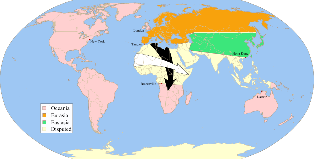
| Description | Fictitious map, illustrating the political landscape of Orwell's Nineteen-Eighty-four, approximate map of the "Black arrows" and "white arrows" described at the end of the book, rendered from Image:1984_fictious_world_map_v2.svg, inspired by Image:1984_fictious_world_map.png and Image:1984_Orwell_arrows_2.png, based on Image:BlankMap-World6.svg, created following Wikipedia's map color standard. | ||
| Date | |||
| Source | Own work | ||
| Author | Twisp | ||
| Permission (Reusing this file) |
|

|
This fictional map image could be re-created using vector graphics as an SVG file. This has several advantages; see Commons:Media for cleanup for more information. If an SVG form of this image is available, please upload it and afterwards replace this template with
{{vector version available|new image name}}.
It is recommended to name the SVG file “1984 fictious world map v2 arr.svg”—then the template Vector version available (or Vva) does not need the new image name parameter. |
Licensing[edit]
| I, the copyright holder of this work, release this work into the public domain. This applies worldwide. In some countries this may not be legally possible; if so: I grant anyone the right to use this work for any purpose, without any conditions, unless such conditions are required by law. |
File history
Click on a date/time to view the file as it appeared at that time.
| Date/Time | Thumbnail | Dimensions | User | Comment | |
|---|---|---|---|---|---|
| current | 20:58, 14 January 2008 | | 1,200 × 609 (235 KB) | Twisp (talk | contribs) | == Summary == {{Information |Description=Fictitious map, illustrating the political landscape of Orwell's [http://en.wikipedia.org/wiki/Nineteen_Eighty-Four Nineteen-Eighty-four],approximate map of the "Black arrows" and "white arrows" described at the en |
You cannot overwrite this file.
File usage on Commons
There are no pages that use this file.
File usage on other wikis
The following other wikis use this file:
- Usage on fa.wikipedia.org
- Usage on fr.wikipedia.org
- Usage on hr.wikipedia.org
- Usage on oc.wikipedia.org
- Usage on ro.wikipedia.org
- Usage on sh.wikipedia.org
- Usage on uz.wikipedia.org