File talk:Presence of Albanians in "Greater Albania".png
Grey zones[edit]
The use of gray ("unknown") to color the Periphery of Epirus is sheer nonsense. Though there is no official data for the number of Albanians in Epirus, there is plenty of non-official data, and all the sources say the same thing: That the number of autochthonous Albanians left in the Periphery of Epirus is VERY small, for sure less than 10%. Sure, there used to be more in the past, but after World War 2 there are almost none left. Also, there is a very strong Greek minority in Gjirokaster and Saranda counties, whose existence is well-documented. Athens2004 (talk) 20:45, 31 August 2010 (UTC)
- the main problem is the title "greater Albania" which is a nationalistic term. The comment above is also correct. Furthermore I don't know if we actually check the validity of any information about languages in the recent states such as Kossovo or R.of.Macedonia.Seleukos (talk) 17:28, 2 September 2010 (UTC)
- Athenean the map documents majorities not "existence of minorities" and there is a source about those but no source that documents a non-Albanian majority. At the moment there are 3 sources for the grey zones part so labeling it as nonsense is very disruptive.--ZjarriRrethues (talk) 21:56, 7 September 2010 (UTC)
- What's disruptive is source falsification, which is what you are engaging in. There are no sources for "Grey zones", there is no such thing as a "grey zone", the CIA factbook does not support any of the claims you make. It is well-known that there are no Cham Albanians left in Epirus, and you know that very well. Athens2004 (talk) 06:27, 8 September 2010 (UTC)
- Not to mention that I have sources that show all of Northern Epirus, from Saranda to Korytsa, as majority Greek. However, in the interests of compromise, I refrained from doing so and left the districts of Kolonia and Korytsa as majority Albanian. Unfortunately, it appears this was interpreted as a sign of weakness, and was pounced upon. First, the Greek minority was erased from the district of Gjirokaster. Next, it was removed from the district of Saranda. And finally, the nonsensical "grey zones were re-added. Next thing you know, the Periphery of Epirus will be shown in purple. Athens2004 (talk) 07:04, 8 September 2010 (UTC)
- The self-published independent researcher Minahan, the supposedly based on Qosja map or that other source that says that Shkoder has a large Greek population aren't RS. The nonsensical grey zones are the reality Athenean because there are 3 very reliable sources that say that. That RSN ended in favor of Vickers and there's also that research by those Greek scholars, who place the number at 60,000. Btw you're comments can be considered npa violations so it would be prudent if you didn't make such comments. I also found Greek spokesmen claimed that 34% of the population of Gjirokaster and 42% of the population of Sarande was Greek(at least that part from that book has the direct statements of the minority leaders), so even the representatives of minorities themselves claim that they're not the majority(although they inflate their numbers like any other minority) and yet you claim that they're a majority although even their own leaders don't say that.--ZjarriRrethues (talk) 06:00, 9 September 2010 (UTC)
- Not to mention that I have sources that show all of Northern Epirus, from Saranda to Korytsa, as majority Greek. However, in the interests of compromise, I refrained from doing so and left the districts of Kolonia and Korytsa as majority Albanian. Unfortunately, it appears this was interpreted as a sign of weakness, and was pounced upon. First, the Greek minority was erased from the district of Gjirokaster. Next, it was removed from the district of Saranda. And finally, the nonsensical "grey zones were re-added. Next thing you know, the Periphery of Epirus will be shown in purple. Athens2004 (talk) 07:04, 8 September 2010 (UTC)
- I'm sorry, which sources say that the periphery of Epirus is a "grey zone"? What is a "grey zone anyway"? Where does the CIA factbook, or any of the other sources, say ANYTHING about "grey zones"? Please stop with this nonsense. The Cham Albanians in Epirus were kicked out at the end of WW2 and there are exactly zero Albanians in Epirus, every source says that, and you know that as well as I do. Regarding sources, since you insist, I added the source from the Le Monde Diplomatique, which shows Northern Epirus as majority Greek. In addition to being a very prestigious source, the other advantage of this source is that it covers the whole area of the map, which is far preferable and scientifically accurate over cherry picking various sources that use different methodologies, have different errors, and so forth. Far better to use a single source for the area, since it exists. Athens2004 (talk) 21:24, 9 September 2010 (UTC)
I was watching this map's changes for many days and I think that Zjarri shouldn't try to convince you because you can't accept the sources even when they come from the minority itself. I may be banned on the English wikipedia on Albanian topics but here I'm not and I won't cause any disruption like Athenean by deleting sources.--I Pakapshem (talk) 21:34, 9 September 2010 (UTC)
Athenean if you're claiming that there are 400 000 greeks in Albania, how come UHRP got only 18,000 votes and only one deputy in the Albanian parliament in the June 28, 2009 elections? --I Pakapshem (talk) 21:47, 9 September 2010 (UTC)
- Please Pakapshem become reasonable: You are already indef banned in english wiki because of massive disruption and endless edit warring.Alexikoua (talk) 22:14, 9 September 2010 (UTC)
I am reasonable. Please become honest. I am not idef banned in english wiki. I am topic banned from certain topics, but that has nothing to do with anything here. I have no restrictions whatsoever in commons. --I Pakapshem (talk) 17:03, 10 September 2010 (UTC)
- I Pakapshem is being way too much reasonable after all that he has had to endure from Athenean : I still conserve this perfect example of how double standards are used by Athenean: while he wikihounded I Pakapshem, me and every Albanian editor he has reported, he was asking me not to follow him around. Athenean actually is probably the reason why many Greek editors are viewed with suspicion by Albanian editors. The map is flawed because it has incorrect information and unsupported by sources in the region of southern Albania where the Albanians seem to be a minority. In addition the gray area in Greece says that no info is provided as to the number of Albanians living there. As a result I will have to revert to last version of I Pakapshem. --Sulmues (talk) 05:55, 10 September 2010 (UTC)
The sources that were used for this map are completely irrelevant. Nothing from there can justify even the existence of this map. It is purely personal work and can not even be considered valid. Actually I have seen from many Albanian editors the same misuse of sources, paragraphs out of context, irrelevant sources etc. Further more the term "greater Albania" is a completely nationalistic term that has to be changed immediately. How would you like to see a map labelled "Greeks in Greater Greece" with big parts of Albania in it? I am tempted to draw oneSeleukos (talk) 09:20, 10 September 2010 (UTC)
- Btw Athenean according to the CIA Factbook page:Demographic percents represent citizenship, since Greece does not collect data on ethnicity. Also this map [1] has many other errors like inflating the number of Albanians in Resen, Macedonia to 30-50%(they are about 10-18%) and that of Zubin Potok to 80-100%(they are about 20%). --ZjarriRrethues (talk) 19:26, 10 September 2010 (UTC)
- The Albanian government also does not collect data on ethnicity, should we show all of Albania in grey as well? Le Monde Diplo is the best source we've got, and you know it. As for Sulmues, he will be reported for his personal attack against me, which is virtually identical to the personal attack that got him banned from WP:AE. Athens2004 (talk) 20:57, 10 September 2010 (UTC)
There are so "many" greeks in Albania that they can't even elect a greek mayor in Gjirokaster or Sarande, which are claimed by greek editors in wiki as centers of the greek minority in Albania, or for that matter in Delvine, Permet or Korce which again the greek editors claim to have substantial greek populations. In fact the only "greek" mayor in Albania, is an Albanian from the Kurvelesh village of Progonat, Vasil Bollano, who got elected in a town that has virtually no greeks. Interestingly enough the supposed greek minority party of UHRP is also led by a non greek, a vlach (Vangjel Dule).--I Pakapshem (talk) 21:10, 10 September 2010 (UTC)
The map is oversourced, we have also this [[2]], Korce should be also noted as Albanian 30-50% area according to this.Alexikoua (talk) 01:56, 11 September 2010 (UTC)
Alexikoua that map is the same as the 1999 one and has the same errors because in Northern Kosovo Albanians are a minority.--ZjarriRrethues (talk) 08:02, 11 September 2010 (UTC)
- Since Greece is shown in "gray" because "the Greek government does not collect data on ethnicity", I will upload a version with Albania in grey, since the Albanian government also does not collect data on ethnicity. Athens2004 (talk) 17:59, 11 September 2010 (UTC)
- The 1989 census had ethnographic data and the 2011 will have them too.--ZjarriRrethues (talk) 19:41, 11 September 2010 (UTC)
- Since Greece is shown in "gray" because "the Greek government does not collect data on ethnicity", I will upload a version with Albania in grey, since the Albanian government also does not collect data on ethnicity. Athens2004 (talk) 17:59, 11 September 2010 (UTC)
- As I see the Albanian team is tagteaming in full power: now Aigest reverts with a completely wrong edit summary. ZRrethoues: please low down the nationalistic paranoia about lost lands and grey zones.Alexikoua (talk) 21:22, 11 September 2010 (UTC)
(unindent)Alexikoua stick to the sources and don't make comments that can be considered npa violations.--ZjarriRrethues (talk) 11:17, 13 September 2010 (UTC)
- What's what you need to do here: for future reference a propaganda census (like in stalinist Albania of 1989) is far from considered wp:rs.Alexikoua (talk) 20:03, 13 September 2010 (UTC)
- Alexikoua please refrain from saying "stalinist Albania" because it may be perceived as an offense. By the way I lived in stalinist Albania and was happy, I think you may have loved it too. When a country has a communist ideology, that does not mean that it gives a false representation of the composition of the population, so I don't understand why you repeat ad nauseam that Albania was a stalinist country. Aren't you tired from saying over and over the same thing? If Albania had an ethnographic census in the 1980s, your Greece never had one, so please stick your comments back, and start having a more critiquing eye for your own country rather than giving opinions about other people's countries. I advise you never say any longer that Albania was a stalinist country because that is offensive and I may report you for breaching ethnic WikiPolicies.Sulmues (talk) 01:52, 14 September 2010 (UTC)
Btw Alexikoua the 1989 census isn't even in the list of sources and you still haven't brought any sources.--ZjarriRrethues (talk) 19:50, 14 September 2010 (UTC)
- This [3] is the only source we need. Using a whole bunch of sources with different methodologies and erros is WP:SYNTH, and we all know that. This source is the only one that covers the entire area in question. The grey zone stuff is OR and unsupported by any sources. If you are going to insist on showing Greece in grey, then the intellectually honest thing to do would be to show Albania in grey as well, as the Albanian government does not collect ethnographic data either. You cannot use a census that will take place in the future to justify showing only Greece in grey. Athens2004 (talk) 23:44, 14 September 2010 (UTC)
(unindent)That map isn't the only soruce we need, but it's the only source you have, although it has too many mistakes.--ZjarriRrethues (talk) 15:32, 15 September 2010 (UTC)
Bibliography is endless, for example we have also this: [[4]], as I see Korca and Erseka are also included.Alexikoua (talk) 21:31, 15 September 2010 (UTC)
- We've been over the self-published highly criticized independent researcher Minahan. Alexikoua I think that I Pakapshem's comment is very useful and please accept the fact even the representatives of the minority say that they aren't a majority, so why can't you accept that? --ZjarriRrethues (talk) 22:02, 15 September 2010 (UTC)
- Minahan? lol, it's not Minahan. It seems you are not even clicking on the links, since bibliography is so overwhelmingly against your extreme points.Alexikoua (talk) 21:26, 16 September 2010 (UTC)
- I will take Le Monde Diplomatique over your OR (too many mistakes) any day. Athens2004 (talk) 01:59, 16 September 2010 (UTC)
- I know you'll take that map any day because that's your only source, but the Kosovo census, the Macedonian census and even the Greek minority itself show your map's mistake.--ZjarriRrethues (talk) 19:31, 16 September 2010 (UTC)
- My suggestion to you is to contact Le Monde Diplomatique and let them know you think their map has "mistakes" and needs to be "corrected". Who knows, they might change it if you ask them nicely. Athens2004 (talk) 20:09, 16 September 2010 (UTC)
- I know you'll take that map any day because that's your only source, but the Kosovo census, the Macedonian census and even the Greek minority itself show your map's mistake.--ZjarriRrethues (talk) 19:31, 16 September 2010 (UTC)
- I will take Le Monde Diplomatique over your OR (too many mistakes) any day. Athens2004 (talk) 01:59, 16 September 2010 (UTC)
(unindent)Newspapers don't create maps themselves. The map is wrong(unless the EU, Macedonia and the Greek minority itself is wrong). Athenean now you know why the map has many mistakes so continuing your reverts will be very disruptive.--ZjarriRrethues (talk) 11:23, 17 September 2010 (UTC)
- You really should try it though. I mean, if ZjarriRrethues says a map is wrong, who is Le Monde Diplomatique to argue against him? As for being disruptive, you have more reverts than anyone, so be careful with the accusations. Athens2004 (talk) 15:05, 17 September 2010 (UTC)
- Seems an entire rs bibliography isn;t enough to stop this nationalistic paranoia lead by Zthoues, no wonder his contributions and activity everywhere is motivated by unstoppable irredentist enthousiasm .Alexikoua (talk) 06:42, 18 September 2010 (UTC)
(unindent)Alexikoua the verdict is on our block logs and sanctions. Your only source is a map that contradicts the official census of 3 countries(one of them was held by the EU). --ZjarriRrethues (talk) 09:11, 18 September 2010 (UTC)
- Which one would that be? The Albanian one, which doesn't include ethnicity? How can an ethnographic map contradict a census that does not include ethnicity? Athens2004 (talk) 16:25, 18 September 2010 (UTC)
(unindent)That would be the one of Kosovo(held by the EU)

- The one of Macedonia

- and the one of Montenegro


All these maps show the mistakes of your only source--ZjarriRrethues (talk) 23:31, 18 September 2010 (UTC)
- What? The red-green map for Kosovo is identical to my map (and your version for that matter). Overwhelming Serb majority (Albanians <10%) in the Zvecan, Leposavic and Zubin Potok districts, and 60% Serb majority (Albs. 20-50%) in Strpce. Ditto for RoM. Albanian majority in Gostivar and Tetovo, strong minorites in the rest of western RoM. It might be a little less fine grained than the census map, but it is funadementally identical. Same for Montenegro. Besides, your version and my version are IDENTICAL for these countries. A question: Where does the CIA factbook say "there are an unknown number of Albanians in Greek Epirus"? (for the "Grey zones"). Athens2004 (talk) 00:22, 19 September 2010 (UTC)
- It isn't identical at all to your map[5]. Your map has 2/3 districts of northern Kosovo as Albanian majority districts and doesn't even mention the Serb majority district on the border with Macedonia, but instead has added as non-Albanian an Albanian majority district in the south. In Macedonia the Prespa district is presented as 30-50% Albanian, which is a too inflated figure. Albanians form exactly 50% in Bar district, not 10-30% in all areas except Ulqin.--ZjarriRrethues (talk) 10:16, 19 September 2010 (UTC)
- Zthoues I'm still waiting for a single argument.Alexikoua (talk) 12:00, 19 September 2010 (UTC)
- So you're not considering the Kosovar, Macedonian and Montenegrin census as arguments against your only source? Alexikoua that's a consice case of IDHT.--ZjarriRrethues (talk) 12:11, 19 September 2010 (UTC)
- Zthoues I'm still waiting for a single argument.Alexikoua (talk) 12:00, 19 September 2010 (UTC)
As always Athenean you keep trolling and considering only your source from some French magazine as reliable, when the sources that Zjarri brings are from the minority itself. And yet you keep accusing other editors of being POV and OR. --I Pakapshem (talk) 20:04, 19 September 2010 (UTC)
- Zthoues: If you feel that there is something wrong with the Montenegrin, Kosovo teritories fix it. Else don't use it as an excuse to create grey zones in Greece and majority areas in southern Albania (suppose that's very easy to understand). Also Monde Diplomatique is one of many sources that confirm the statistics in southern AlbaniaAlexikoua (talk) 20:18, 19 September 2010 (UTC)
(unindent)Alexikoua the sources were brought and if you have any other source bring it but don't revert others in this very disruptive way.--ZjarriRrethues (talk) 20:25, 19 September 2010 (UTC)
- Zthoues: Montenegrin, Kosovo censi are irrelevant with Greece and southern Albania. Suppose that's a typical part of a disruption only activity (you and indef blocked in english wiki Pakapshem) you cause everywhere.Alexikoua (talk) 20:41, 19 September 2010 (UTC)
- I'm still waiting for you to present material about south Albania & Greece that support your version (until now we have nothing instead of blind reverts and misuse of obvious facts [[6]]).Alexikoua (talk) 20:42, 19 September 2010 (UTC)
(unindent)You had only one source and that was full of errors that I showed. Now you have no sources, so any revert from your part will be considered extremely disruptive.--ZjarriRrethues (talk) 20:49, 19 September 2010 (UTC)
@ZT: What on earth are you talking about? Albanians 50% in Bar? Where do you see that on the census map. Regarding Kosovo, both my map and the red-green census map are in complete agreement. I think you need to take off you red-and-black tinted glasses and have a better look. 3 districts in north Kosovo overwhelmingly Serbian (Albs. less than 10%), and in the district of Srtpce in the south, Serbs are 60%, therefore Albanian 20-50%. Regarding Rom, Tetovo, Gostivar, and two other districts to the west majority Albanian, as is the district of Struga. My map and the censi are in complete agreement. And answer my question: Where do you see the CIA factbook justifying grey zones? Answer please, don't evade. Athens2004 (talk) 20:52, 19 September 2010 (UTC)
- Your map only has Leposavic as Serbian majority district(and that southern district on your map isn't strpce), the Prespa region is wrong and CIA says note: percents represent citizenship, since Greece does not collect data on ethnicity. Now we have a whole week to resolve this.--ZjarriRrethues (talk) 20:57, 19 September 2010 (UTC)
- Wrong. My map is somewhat lower resolution, so what you think is Leposavic is in fact all three districts, and it IS Strpce by the way. Like I said, it seems you need to get a new pair of glasses. By the way note: percents represent citizenship, since Greece does not collect data on ethnicity does not mean There is an unknown number of Albanians in epirus. We have sources, (GHM, monde Diplo, and many many others, even Vickers) and they all tell us one thing: Albanians are very few in Epirus. In Florina there are only three villages. Do you think that there could possibly be more than 1-2% albanians in florina? The Albanian government does not collect data on ethnicity either, so by your logic we should show all of Albania in grey as well. Anyway, given the intensity of the WP:IDHT, and the fact that you guys are obviously not interested in an agreement, I have removed the map from the pages of wikipedia for now. At least there Pakapshem is unable to disrupt thanks to his topic ban. And zt, I would strongly adivese you against edit warring there, lest it be your turn to find yourself the subject of an AE report. I think it's time. Athens2004 (talk) 22:54, 19 September 2010 (UTC)
- (unindent)Athenean it would be prudent not to make wikithreats and please that is just Leposavic(you can see very clearly the other two districts below Leposavic) and Strpce is on the Kosovan-Macedonian border not the Kosovan-Macedonian-Albanian border. The district shown on your map is Dragas--ZjarriRrethues (talk) 23:10, 19 September 2010 (UTC)
- The main issue is and remains the ridiculous "grey zones" in Greece. "No official data" is not the same "No data at all". True, there is no OFFICIAL data, but there is plenty of non-official data. Sources do exist, such as Ethnologue, which shows 10,000 Albanian speakers in Epirus [7], none in Kastoria, and only a handful in Florina. Less than 10%. You do not have a single source that shows more than 10% Albanians in any of these districts. Therefore they should be shown in white. Athens2004 (talk) 01:42, 20 September 2010 (UTC)
- The name of this map must change! It should be called "Presence of Albanians in Balkan states" or something like that. The term "Greater Albanian" is of course a nationalist term like "Greater Serbia" or Greater Greece". Yet again I have to say that I am extremely tempted to make a map of the "Presence of Greeks in Greater Greece" and I will make sure to incorporate all of North Epirus/Southern Albania. I assume that all Albanian editors who don't have a problem with "Greater Albania" wouldn't have a problem with "greater Greece"!Seleukos (talk) 10:42, 20 September 2010 (UTC)
- I don't understand why the Greek side insists on putting the Albanians at a minority in their own country if the Greek scholars themselves don't give more than 60k Greeks in Albania (while the Albanian government sustains that 30k is a more appropriate number). Taking numbers from nationalistic Greek sites makes a poorer wikipedia. Sulmues (talk) 12:13, 20 September 2010 (UTC)
- There is still not a 'single' argument given why the typical Albanian team I_Pakapshem & his tag-teammate ('possible' sock of Sarandioti&socks per spi) insists on labeling grey zones in nw Greece as well considering parts of southern Albanian as a Albanian majority zone. Seems the typical more than a year now disruption is still in action. By the way wp:rsn says that Monde Diplomatique is 100% fine.Alexikoua (talk) 13:12, 20 September 2010 (UTC)
(unindent)[8] Another map by the same cartographer and it seems that he contradicts himself. Btw Alexikoua it would be prudent not to make comments that are personal attacks.--ZjarriRrethues (talk) 14:41, 20 September 2010 (UTC)
- Agree with Seleukos about the name, the current one is unacceptable. @Zjarii: Let's go prefecture by prefecture. We all know that in Florina there are only 3 Albanian speaking villages, and not more. Therefore, there is no way Albanians make up more than 10% of the prefecture, therefore, the prefecture should be shown in white. So far, so good?
- If we do that in Greece, we ought to do it also in Albania and go village by village throughout the Districts of Gjirokaster and Sarande and you'll see that the Albanians are in clear majority. --Sulmues (talk) 18:31, 20 September 2010 (UTC)
While everyone's focused on this map, I'd like to suggest that the ranges be changed to something like 'less than 10%', '11%-25%', '26%-50%', '51%-75%', 'more than 75%'. I don't think the current ones work because 'more than 50%', for example, could mean 51% or 100% which is a big difference. This way, it's at least a little less vague. Local hero (talk) 18:44, 20 September 2010 (UTC)
- Excellent idea, I was about to suggest it myself. I propose dark blue for 50-80% and purple for 80-100%. Having only one color for greater than 50% is too coarse. Athens2004 (talk) 20:43, 20 September 2010 (UTC)
- Btw Athenean did you take a look at the second map of LMD created by the same chartographer? It's quite different and has some data on Albanian populations in Epirus periphery, which is quite interesting.--ZjarriRrethues (talk) 11:36, 21 September 2010 (UTC)
- Answer the question about Florina and Kastoria first. Do you or do you not agree that there is no way Albanians are anywhere close to 10% in those prefectures? Please give a straight answer, don't avoid. Athens2004 (talk) 18:09, 21 September 2010 (UTC)
- I could speculate but I couldn't be able to give a definite answer. The Albanians of Florina are probably about 3-6% and those of Kastoria about 2-4%, but if someone said that they are more than 10% then it would be a bit difficult to confront that speculation.--ZjarriRrethues (talk) 08:14, 22 September 2010 (UTC)
- Answer the question about Florina and Kastoria first. Do you or do you not agree that there is no way Albanians are anywhere close to 10% in those prefectures? Please give a straight answer, don't avoid. Athens2004 (talk) 18:09, 21 September 2010 (UTC)
- It's never difficult to confront WP:OR, including your claim of 3-6% and 2-4%, for which you have zero evidence. There are are only 3 villages in Florina and none in Kastoria, so there is no way they are anywhere near 10%. Done. Next: Periphery of Epirus: According to Ethnologue, there are only 10,000 Albanian speakers. Population of the periphery of Epirus: 400,000. Again, no way they are more than 10%. Athens2004 (talk) 14:54, 22 September 2010 (UTC)
(unindent)Even if we use that only that estimate that doesn't mean that their population density is the same in all of Epirus periphery, whose population is 360,000 and not 400,000. In this map Arta isn't included, so we're discussing about the percentage of the Albanian population in about 280,000 people. The vast majority of the Albanians live either in the prefecture of Thesprotia, Preveza or the northern part of Janina, so even if we use only ethnologue then 10%> is an easy deduction, but since Greece doesn't collect such data we can only speculate.--ZjarriRrethues (talk) 21:46, 22 September 2010 (UTC)
- Thesprotia and Preveza = 105,000. Even if they all live in only those two prefectures, they are again less than 10%. So we have at least two sources (Ethnologue and several LMD maps) that show Albanians less than 10% in Epirus.Athens2004 (talk) 20:42, 23 September 2010 (UTC)
New source[edit]
Propose the creation of a new map based on this source [9]. It is academic, from Sciences Po, and shows the area as a whole, so no synth. Athens2004 (talk) 00:34, 23 September 2010 (UTC)
![[9]](http://www.google.gr/imgres?imgurl=http://cartographie.sciences-po.fr/cartotheque/42C_albanais.jpg&imgrefurl=http://cartographie.sciences-po.fr/index.php%3Fq%3Dfr/node/9%26support%3D1%26echelle%3D%26pays%3D%26theme%3D3%26a%3D1&usg=__7KC4BkKymbLz0epiRfamb56hoXQ=&h=745&w=871&sz=224&hl=el&start=294&zoom=1&tbnid=_GN_cwcND1qKRM:&tbnh=152&tbnw=176&prev=/images%3Fq%3Dminorite%252Balbanie%252Bepir%2Bdu%2B)
- That's the LMD map of the same cartographer published by another source with some minor changes(the Greek minority is shown as present in some areas but not the majority and the Kosovo and Macedonia Albanian areas have been mostly corrected). Btw why don't you want to use the second LMD map? It shows percentages of Albanians too in the Epirus periphery.--ZjarriRrethues (talk) 18:01, 23 September 2010 (UTC)
- Since you say the mistakes have been corrected, I'll take that as a yes. I'll also remind you that the RSN discussion agreed that LMD is a very high quality source. Btw The second LMD map shows two Albanian dots in Epirus, not "percentages". Athens2004 (talk) 20:39, 23 September 2010 (UTC)
- The RSN also said to continue discussions about our disputes so after the full protection expires don't make any changes that might be reverted.--ZjarriRrethues (talk) 13:32, 26 September 2010 (UTC)
- Seems we have again this national paranoia of wthnic purity by the typical Zjari&Pakashem team fightinh against the entirety of bibliography.Alexikoua (talk) 13:53, 26 September 2010 (UTC)
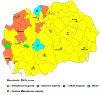
Macedonian municipalities[edit]
I do not know who has changed the colours of the municipalities in Macedonia, but they were totally wrong. I have corrected the Macedonian municipalities according to the latest Macedonian census and they are now ok. Previously was done according someone's imagination. Best, --MacedonianBoy (talk) 11:18, 12 October 2010 (UTC)