File talk:Kurdish-inhabited area by CIA (1992).jpg
This image originated from en.wikipedia.org. List of contributors:
- [2003-06-15T07:21:50Z] Jdforrester (Map of Kurdish-populated area, cropped, shrunk)
- [2003-06-15T07:26:19Z] Jdforrester (Added source reference)
- [2003-06-22T10:36:25Z] Jdforrester (Added other versions)
- [2004-12-10T05:33:04Z] Squash (Unverified: [[Wikipedia:Untagged Images|Thousands of images have no copyright tags. You can help sort this out by clicking on this link!]])
- [2005-07-27T07:54:46Z] Thuresson (NowCommons)
- [2005-07-29T17:14:46Z] 160.75.61.118
- [2005-10-07T21:44:50Z] JesseW (commons says it's licensed and sourced)
- [2005-12-28T06:20:10Z] 172.205.193.184 (remove vandalism)
Original title:
- Kurdish_lands_92_cropped_small.jpg
Upload log:
- (del) (cur) 07:34, 15 June 2003 . . Jdforrester (Talk | contribs) . . 300×250 (19,316 bytes) (Map of Kurdish-populated area, cropped, shrunk, fixed)
- (del) (rev) 07:21, 15 June 2003 . . Jdforrester (Talk | contribs) . . 300×250 (26,361 bytes) (Map of Kurdish-populated area, cropped, shrunk)
Text:
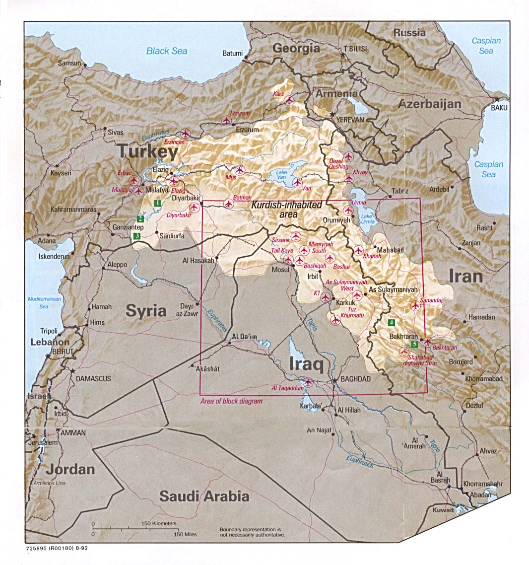
Map of Kurdish-populated area, cropped, shrunk "Map of Kurdistan courtesy of The General Libraries, The University of Texas at Austin" according to [[Kurds]] Other versions: * [[Media:Kurdish_lands_92_cropped.jpg|Pre-shrink version]] * [[Media:Kurdish_lands_92.jpg|Pre-shrink, uncropped version]] (source) {{NowCommons|Image:Kurdish lands 92 cropped.jpg}} According to the commons image page: {{PD-USGov-CIA}}
Poccil 23:38, 2 September 2006 (UTC)
.jpg#c-Poccil-2006-09-02T23:38:00.000Z)
Abuse of Information[edit]
.jpg&action=edit§ion=1)
This page says that the map is the Kurdish Lands. However, Kurds do not have any land. Please corrent this wrong information since it is an insult to my country: Turkey.
At the source, where this map is taken says, this is the Kurdish inhabitant area. This is correct but its not Kurdish lands.
Please correct it as in source... —the preceding unsigned comment is by 88.232.152.218 (talk • contribs)
- Done. --Cat out 19:36, 9 February 2007 (UTC)
.jpg#c-Cool_Cat-2007-02-09T19:36:00.000Z-Abuse_of_Information)
Marked area on map has changed[edit]
.jpg&action=edit§ion=2)
It looks to me like in the most recent revision (by User:Saadwand) the marked area on map has changed. Given that the map is still attributed to the CIA at a certain date, I can't see how that can be legitimate. - Jmabel ! talk 05:47, 27 July 2010 (UTC)
.jpg#c-Jmabel-2010-07-27T05:47:00.000Z-Marked_area_on_map_has_changed)
The map is not attributed to the CIA. It is the work of some User. User saadwand's version is the the exact version.Leosan (talk) 20:49, 13 August 2010 (UTC)
.jpg#c-Leosan-2010-08-13T20:49:00.000Z-Marked_area_on_map_has_changed)
- The summary given attributes the map to the CIA. - Jmabel ! talk 21:33, 13 August 2010 (UTC)
.jpg#c-Jmabel-2010-08-13T21:33:00.000Z-Leosan-2010-08-13T20:49:00.000Z)
- I've posted the following to the Village Pump:
Either I am misunderstanding what is going on at File:Kurdish-inhabited area by CIA (1992).jpg or someone else is. My understanding is that a map that is attributed to the CIA at a particular date has been altered. It may or may not be more factual as to what are actual Kurdish areas, but as I see it the summary is now inaccurate, and even if it is more factual there should probably be two different images, one showing what the CIA said in 1992 and the other showing the derivative work. But User:Leosan, for one, seems to think I misunderstand. And perhaps I do. I think some other eyes are needed.
.jpg)
- - Jmabel ! talk 21:40, 13 August 2010 (UTC)
- The following comments are copied from the Village Pump. - Jmabel ! talk 05:08, 14 August 2010 (UTC)
- I tend to agree that a large change such as that should be uploaded under a separate file name. Powers (talk) 23:53, 13 August 2010 (UTC)
- If even the map's content (different size of bright area) is changed it should be definitely a new file (derivativeFX helps). By the way: jpg is the worst file format for a map which was changed several times based on the the previous version. Should have been converted to png. Best is now to save the new version as png and upload it as a new file to be prepared for further changes. Cheers --Saibo (Δ) 01:51, 14 August 2010 (UTC)
- End copied comments - Jmabel ! talk 05:08, 14 August 2010 (UTC) - Jmabel ! talk 05:08, 14 August 2010 (UTC)
.jpg#c-Jmabel-2010-08-13T21:40:00.000Z-Leosan-2010-08-13T20:49:00.000Z)
.jpg#c-Jmabel-2010-08-14T05:08:00.000Z-Leosan-2010-08-13T20:49:00.000Z)
.jpg#c-LtPowers-2010-08-13T23:53:00.000Z-Jmabel-2010-08-14T05:08:00.000Z)
.jpg#c-Saibo-2010-08-14T01:51:00.000Z-Jmabel-2010-08-14T05:08:00.000Z)
.jpg#c-Jmabel-2010-08-14T05:08:00.000Z-Leosan-2010-08-13T20:49:00.000Z-1)
Again, after recent changes (and near edit-war): It seems to me that the map at this name should be as close as possible to the original CIA map (including even the "irrelevant" box). It is perfectly acceptable to upload a map of your own that you believe more accurately reflects the situation, but that should be at a different name and should be explicitly described as a derivative work. - Jmabel ! talk 16:52, 14 August 2010 (UTC)
.jpg#c-Jmabel-2010-08-14T16:52:00.000Z-Marked_area_on_map_has_changed)
- Currently, this file is indefinitely protected due to a history of edit warring. Kintetsubuffalo, one of the participants in the edit war, has added the {{Remove border}} tag.[1] It seems to me that it would be helpful to obtain a consensus on this page that the border should be removed before adding the remove border tag. If such is obtained, I will be happy to lift the protection so that a new version may be uploaded. Without such a consensus, I think the remove border tag is pointless. I think it would be better if Kintetsubuffalo were to upload his/her preferred version under a new filename marked as a derivative of this file. --Walter Siegmund (talk) 03:53, 1 April 2012 (UTC)
![[1]](https://secure.wikimedia.org/wikipedia/commons/w/index.php?title=File:Kurdish-inhabited_area_by_CIA_(1992).jpg&action=history)
.jpg#c-Wsiegmund-2012-04-01T03:53:00.000Z-Jmabel-2010-08-14T16:52:00.000Z)
Protection[edit]
.jpg&action=edit§ion=3)
Wsiegmund Please lift the page protection on this file. It appears that the image shown is not the original image, but a cropped version. This should be rectified, as the crop has omitted the important caveat at the bottom of the page "Boundary representation is not necessarily authoritative." (This can be seen in the original map, visible here.) Since this file is used a lot on various projects, this necessary proviso should be visible to users of the map, as the CIA cartographers intended. It would have the additional benefit of dissuading any use of the map as an authoritative assessment rather than an illustrative approximation. In addition, the present file's resolution in dots-per-inch is about half as good as it could be if the full, untampered-with image were used. At present, the "Please do not overwrite this file" notice is highly misleading and misrepresents this image as the original map as issued, rather than an unexplained, truncated, inset of the original. GPinkerton (talk) 01:56, 22 May 2021 (UTC)
.jpg#c-GPinkerton-2021-05-22T01:56:00.000Z-Protection)
- @GPinkerton: I believe the full map is at File:Kurdish_lands_92.jpg (which is linked here). Are you saying that this is not an accurate crop of that map, or what? What exactly do you propose to do? (If it's just a higher resolution of that, I'd do that there, not here, for sure.)
- I'd have no problem temporarily removing protection for a specific agreed-upon change, then restoring it, but this image cannot be left unprotected long term, it was way to much of a trouble target. - Jmabel ! talk 05:37, 22 May 2021 (UTC)
- Jmabel I'm saying neither file has the full image (which has a border, a code, and a date) which appears on the website the image is purportedly taken from. The map was prepared alongside (or as part of) this infographic, also from 1992. I propose to overwrite this file here with the full image from the website linked here. That way the uncropped, full resolution file will be available for use and credited correctly, and cropped versions of any part can be made as separate files and used according to need. The default file (and the one used by default across the projects using the file) should be the best quality, uncropped version, not a low-res crop of a crop. I agree that the file should be protected, but it should preserve the original image, not this present substitute. GPinkerton (talk) 06:34, 22 May 2021 (UTC)
- @GPinkerton: I think that should be uploaded as a separate file and linked here and from File:Kurdish_lands_92.jpg. Obviously, they are not interchangeable, and it is fully valid to have a detail image. - Jmabel ! talk 15:00, 22 May 2021 (UTC)
- Jmabel It is not fully valid to have a detail image that does not advertise itself in the file name and which demands not to be overwritten because it falsely claims to be the original map as prepared. Something needs to change. Either the claim that "this file is the original and ought not to be overwritten" should be removed or the file should be overwritten with the original image and the label announcing it as such can then remain in place. We can't have a cropped image masquerading as as the original. GPinkerton (talk) 15:05, 22 May 2021 (UTC)
- @GPinkerton: Nowhere does this claim to be the full map.
As I said, upload the full map under a different URL, and we can edit the text here to indicate that it is a detail of that map. - Jmabel ! talk 18:14, 22 May 2021 (UTC)
- @GPinkerton: I think that should be uploaded as a separate file and linked here and from File:Kurdish_lands_92.jpg. Obviously, they are not interchangeable, and it is fully valid to have a detail image. - Jmabel ! talk 15:00, 22 May 2021 (UTC)
- Jmabel I'm saying neither file has the full image (which has a border, a code, and a date) which appears on the website the image is purportedly taken from. The map was prepared alongside (or as part of) this infographic, also from 1992. I propose to overwrite this file here with the full image from the website linked here. That way the uncropped, full resolution file will be available for use and credited correctly, and cropped versions of any part can be made as separate files and used according to need. The default file (and the one used by default across the projects using the file) should be the best quality, uncropped version, not a low-res crop of a crop. I agree that the file should be protected, but it should preserve the original image, not this present substitute. GPinkerton (talk) 06:34, 22 May 2021 (UTC)
.jpg#c-Jmabel-2021-05-22T05:37:00.000Z-GPinkerton-2021-05-22T01:56:00.000Z)
.jpg#c-GPinkerton-2021-05-22T06:34:00.000Z-Jmabel-2021-05-22T05:37:00.000Z)
.jpg#c-Jmabel-2021-05-22T15:00:00.000Z-GPinkerton-2021-05-22T06:34:00.000Z)
.jpg#c-GPinkerton-2021-05-22T15:05:00.000Z-Jmabel-2021-05-22T15:00:00.000Z)
.jpg#c-Jmabel-2021-05-22T18:14:00.000Z-Jmabel-2021-05-22T15:00:00.000Z)
Jmabel Yes it does! Look:
Please do not overwrite this file: any cropping or other restoration work should be uploaded with a new name and linked in this page's "other versions=" parameter, so that this file represents the exact file found in the CIA catalog record to which it links. The metadata on this page was imported directly from CIA's catalog record; additional descriptive text may be added by Wikimedians to the template below with the "description=" parameter, but please do not modify the other fields
Clearly this is misleading. "this file represents the exact file found in the CIA catalog record to which it links" is an outright falsehood. The file uploaded here is no such thing. GPinkerton (talk) 19:15, 22 May 2021 (UTC)
.jpg#c-GPinkerton-2021-05-22T19:15:00.000Z-Protection)
@GPinkerton: You can either upload the whole map (in which case I will link it here with an appropriate indication that this is a crop) or you can choose not to do that. - Jmabel ! talk 00:06, 23 May 2021 (UTC)
.jpg#c-Jmabel-2021-05-23T00:06:00.000Z-Protection)
- Jmabel No, the whole map should be uploaded to this file, or else the bogus label quoted above should be removed. Please lift the protection in order to allow this copyright issue to be corrected. GPinkerton (talk) 01:32, 23 May 2021 (UTC)
.jpg#c-GPinkerton-2021-05-23T01:32:00.000Z-Jmabel-2021-05-23T00:06:00.000Z)
@GPinkerton: You can either upload the whole map (in which case I will then link it here with an appropriate indication that this is a crop) or you can choose not to do that. Those who have transcluded this file should not be surprised by having their image of this detail replaced by the full map. - Jmabel ! talk 05:21, 23 May 2021 (UTC)
.jpg#c-Jmabel-2021-05-23T05:21:00.000Z-Protection)
- Jmabel On the contrary, those who have transcluded the file did so on the understanding that this is the full map, as stated explicitly in the description, as implied by the file's name, and as per the label claiming a bogus origin for the file. Everything that is wrong at present can be corrected by uploading the proper image in its proper place, i.e., here. Should users require a cropped version of lower resolution, then that option will also be available and advertised accordingly. GPinkerton (talk) 05:33, 23 May 2021 (UTC)
.jpg#c-GPinkerton-2021-05-23T05:33:00.000Z-Jmabel-2021-05-23T05:21:00.000Z)
.jpg&oldid=563216129)