File talk:Europe map 1648.PNG
Wasn't the Dutch Republic called UNITED PROVINCES at the time???
Why is Wales shown as part of England? Is it because it is a principality and not a kingdom?
sources of information[edit]
this is excellent work... but what sources are used for the information?
it says penguin atlas of world history... which edition? what year was it published? did a penguin write it?
as for the name changes, like tsardom of russia, do they come from the atlas or from other sources? Decora (talk) 06:43, 11 November 2009 (UTC)
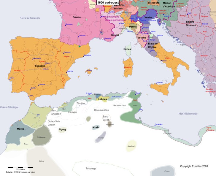
still mistake for the border between frence and spain : catalunya border is north (actual Pyrénées-orientales minus fenouilledes is in Spain) see : https://www.euratlas.net/history/europe/1600/1600_sud-ouest.jpg — Preceding unsigned comment was added by 78.226.210.217 (talk) 09:34, 23 January 2018 (UTC)
Reverted to the older version[edit]
The map given in link (https://commons.wikimedia.org/wiki/File:Europe_1648_westphal_1884.jpg) has many mistakes. The borders of Savoy, Poland, Austria... are false; the Baltic Sea islands are shown as being Swedish although they belonged to Denmark. This map can not be used as source.
The Catalan countries were occupied by France at this time (cf. https://ca.wikipedia.org/wiki/Rep%C3%BAblica_Catalana).
The version to which it has been reverted is quite imprecise (Curland, the Venetian islands are not shown.) — Preceding unsigned comment added by Ambroise Lescop (talk • contribs) 10:42, 19 July 2018 (UTC)
- This is supposed to be based on a historical map. Before making up your own arbitrary non-existent map, you should point to your sources. There was war between Spain and France taking place in Catalonia at that time, but no map of the 17th century was ever created with Catalonia as part of France, and, of course, the treaty of Westphalia (which is what this map is about) never ceded Catalonia to France. So please stop reverting to your imaginary map without basing it on a real map.--Raderich (talk) 12:23, 25 September 2018 (UTC)