File talk:Annexation of Southern and Eastern Ukraine.svg
Map "error"[edit]
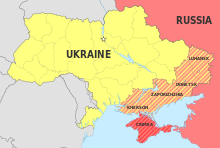
The map description (at least on the English Wikipedia page) says Ukranian oblasts, so the territory of the Mykolaiv Oblast south of the Dnieper–Bug estuary, the western half of Kinburn Peninsula, should remain in yellow but the red line should be extended to show it is currently Russian-controlled. Rogl94 (talk) 13:02, 30 September 2022 (UTC)
Map issues[edit]
Suggestions for improvements, including some serious problems with pro-Russian POV. I’ll list them in separate paragraphs, in case any needs their own discussion thread. There are good reference maps in the Guardian[1] and Washington Post,[2]
I think the legend is probably not needed at all: labels associated directly with map entities are better. The legend entries have inconsistent grammatical number. Some are singular, some plural, and the star has both. —Michael Z. 2022-09-30 20:21 z 20:21, 30 September 2022 (UTC)
The yellow area on the map is not Ukraine: it is only part of it. If you fill Ukraine with three colours, you can’t just call one of them “Ukraine.” This represents a pro-Russian POV. If you’re mapping different things, then you have to use different kinds of representation (fill, hatching, borders, etcetera). I suggest using label, label position, and distinctive international boundary for Russia, Ukraine, and other legal states, and remove them from the legend. —Michael Z. 2022-09-30 20:21 z 20:21, 30 September 2022 (UTC)
International boundaries should all be heavier in weight than all internal boundaries. This current map has a pro-Russian POV by moving the international border into Ukraine, and omitting the oblast–republic boundaries at the Crimean isthmus. It would also benefit from adding the maritime boundary through the isthmus and Kerch Strait.
The dashed red line has no label or legend. I suggest use shading, for currently Russian-occupied territory, and a less prominent line or no line for the line of contact, because this is ephemeral. Oblast boundaries are permanent. —Michael Z. 2022-09-30 20:21 z 20:21, 30 September 2022 (UTC)
What do the red arrows represent? If they’re not specific mapped routes of something, maybe they don’t belong. —Michael Z. 2022-09-30 20:21 z 20:21, 30 September 2022 (UTC)
“Capital city of oblasts” is incorrect. They are not really capitals, but administrative centres, or oblast centres. They should be circles, not stars, or more prominent circles if they are contrasted with non-centres. Simferopol is the administrative centre of an autonomous republic. Sevastopol is a city with special status. Kyiv is the national capital (and an oblast centre}. But why bother explaining what kind of cities they are at all? the map would benefit from other war-affected or nearby cities, especially Kharkiv, Mykolaiv, Odesa, Belgorod (and maybe Lyman, Balakliia, Kupiansk, Bakhmut, Mariupol), or maybe include all oblast centres and comparable cities. —Michael Z. 2022-09-30 20:21 z 20:21, 30 September 2022 (UTC)
- Look @Mzajac, this map intends to represent the RUSSIAN annexation, it's obvious that Russian colours are going to be predominant, just see other annexation maps like these:
- Should there be a third colour not so red for USSR annexed lands? This map doesn't intend to be a map that shows the territorial dispute between Russia and Ukraine. As for your suggestion of including more cities let me know what you think. Basque mapping (talk) 15:18, 8 October 2022 (UTC)
- Those example maps of annexations post facto all have initial international boundary lines more prominent than claims. Those all show de facto annexations, not claims beyond actual military control on the ground, as is the case in Ukraine. So the situation in Ukraine now is Russian-aspirational and less real than in those three, but its visual representation is as something more real or permanent.
- I don’t understand what you mean by doesn’t intend to show the territorial dispute. If you’re saying it’s the Russian ideological, anti-Ukrainian POV then it is non-neutral POV, and is not suitable for Wikipedia. If that’s the case, then it should be clearly labelled as such. I see that it may be the case, as the green area corresponds to Putin’s fascist view of “so-called ‘Ukraine.’”
- (Why not map Zirinovsky and Medvedev’s fantasies too, with parts annexed by Poland, Romania, and Hungary? Why not find open-source propaganda maps by propagandists, instead of duplicating them and presenting them as something else?)
- Maybe we need another map. —Michael Z. 2022-10-10 15:30 z 15:30, 10 October 2022 (UTC)
Edit request: In legend, change "Ukraine" to "Rest of Ukraine"[edit]
The current legend could give the (incorrect) impression that the annexed regions are no longer part of Ukraine. Hebsen (talk) 01:47, 1 October 2022 (UTC)
- Hardly an elegant solution. I have never seen a map with such a label. Better to do it right. —Michael Z. 2022-10-01 19:52 z 19:52, 1 October 2022 (UTC)
- Labeling only the area outside the annexation claims as "Ukraine" is definitely wrong. "Rest of Ukraine" might not be the perfect option (feel free to propose something else) but it's definitely better than what we have now. --mfb (talk) 04:29, 5 October 2022 (UTC)
Arabic version in the other versions fields[edit]
Can you please add this image to the other version field?
-
Arabic
--Michel Bakni (talk) 17:33, 1 October 2022 (UTC)
German translation[edit]
I would like to upload a new version of the file including German translations for all text elements; each language version being defined with the systemLanguage attribution. --Nachtbold (talk) 20:20, 1 October 2022 (UTC)
- I uploaded said revision as File:Annexation of Southern and Eastern Ukraine EN-DE.svg. --Nachtbold (talk) 12:00, 2 October 2022 (UTC)
The border of Kherson oblast[edit]
Could someone please explain what is going on with the border of Kherson oblast? There are three borders - the dashed line denotes the extent of the Russian occupation zone, the thick line supposedly marks the official border of the oblasts, whereas the thin, dotted line is?.. Because the thick line is actually incorrect in the case of Kherson, and that weird dotted line marks the official border... I'm not getting it. And there is no legend, so it's anyone's guess. Is this some kind of a Russian stance on the issue of borders? Because I haven't heard of any, and it seems like an oversight. Adûnâi (talk) 20:46, 1 October 2022 (UTC)
- I agree, there needs to be a legend. The thick line includes some area of Mykolaiv Oblast that some of the Russian maps claim as part of "their" Kherson Oblast. But there are differing versions of border lines circulating in Russian media as far as I can tell, only the western half of Kinburn Peninsula, which is part of Mykolaiv Oblast, seems to always be included in the Russian Kherson Oblast. Rogl94 (talk) 09:05, 4 October 2022 (UTC)
- We have 3 objects
- 1.Kherson oblast Ukraine as de jure subject (partly controlled by Ukraine)
- 2.Kheron oblast Russia as de jure subject and oficial map already sells in store. (parly controlled by Russia)
- 3.Territory of Ukrane de facto controlled by Russia
- And this three differ article. ArasakaV (talk) 00:52, 14 October 2022 (UTC)
New version without front line and legend[edit]

Hello User:Adûnâi, User:Hebsen, User:Mfb, User:Mzajac , User:Nachtbold, User:Rogl94.
I just made this new version without the controversial legend and the undated/unsourced frontline.
I hope it will solve most of the neutrality problems.
Regards, Şÿℵדαχ₮ɘɼɾ๏ʁ 15:17, 6 October 2022 (UTC) Şÿℵדαχ₮ɘɼɾ๏ʁ 15:17, 6 October 2022 (UTC)
- Hi SyntaxTerror! I think painting the oblasts in a third, separate color is the best option for now. What we could do to improve neutrality is to not use that green/red combination due to the obvious associations those colors cause. We could paint the Ukraine blue and the annexed areas yellow for an example. Best regards, --Nachtbold (talk) 07:44, 7 October 2022 (UTC)
- this map shows us oblast Russia as de jure subject and oficial map already sells in store. (parly controlled by Russia). This don't like ukrainian but this is de jure map
- we need separate this map and map real today control of territory.
- Occupation Ukraine by Russia de facto and territorial claim de jure is two different things.
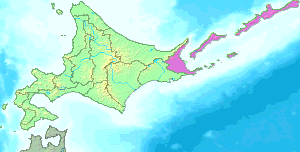
- Look at Sakhalin Oblast and
 . ArasakaV (talk) 00:59, 14 October 2022 (UTC)
Restoration[edit]
@Basque mapping: The map in the current version simply a blatantly illegal border, I suggest we revert this. Habitator terrae 🌍 15:20, 8 October 2022 (UTC)
I suggest this version is the "most" neutral. Habitator terrae 🌍 15:22, 8 October 2022 (UTC)
- @Habitator terrae That would be great for a map showing the territorial dispute, this is a historical moment that show RUSSIAN expansion. Basque mapping (talk) 15:44, 8 October 2022 (UTC)
- "a historical moment that show RUSSIAN expansion" (propaganda terms) aka "the territorial dispute" (neutral terms) aka the illegal annexation (legal terms). Habitator terrae 🌍 16:23, 8 October 2022 (UTC)
- @Basque mapping: I don't see any differences between the terms, other then their framings. Habitator terrae 🌍 16:32, 8 October 2022 (UTC)
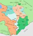
- @Habitator terraeFor instance, how many countries have so far recognized Annexation of Western Sahara? Just the USA. Should we say this map is propaganda because it doesn't show the Sahara with a third colour? It even doesn't show actual control of Morocco in the zone.
Basque mapping (talk) 17:31, 8 October 2022 (UTC)
- This isn't only about the colours, but also the border-line. Habitator terrae 🌍 18:18, 8 October 2022 (UTC)
- @Habitator terrae I've changed the border-line. Let me your thoughts. Basque mapping (talk) 21:34, 8 October 2022 (UTC)
- I only now see, that your example is mostly wrong: Your map show occupational zones, not annexations. Furthermore, there isn't a border between the to parts of West Sahara. Habitator terrae 🌍 11:36, 9 October 2022 (UTC)
- @Habitator terrae I've changed the border-line. Let me your thoughts. Basque mapping (talk) 21:34, 8 October 2022 (UTC)
- This isn't only about the colours, but also the border-line. Habitator terrae 🌍 18:18, 8 October 2022 (UTC)
- @Basque mapping: Ping. Habitator terrae 🌍 14:51, 10 October 2022 (UTC)
Non-neutral POV[edit]
The overall problem with this map is that it is describing Russian claims in the middle of a war, but adopting the visual language of other maps showing actual annexations post facto (in fact, as I’ve described above, it is even going beyond them, showing the Kremlin’s idealized future map of international boundaries that don’t exist).
The correct prototypes for this map is any map of successful historical annexations. It should be current news maps of aspirational Russian claims during its de facto invasion and occupation in progress. —Michael Z. 2022-10-10 15:51 z 15:51, 10 October 2022 (UTC)
- Examples to look to:
- Non-news media:
- Council on Foreign Relations[17]
- Every one of these maps shows Ukraine as Ukraine. They show the “annexed” claims as oblasts of Ukraine. They don’t show the newly “annexed” claims the same way as they show the occupied Crimea. Many of them show the pre-February 24 Russian-occupied Donbas. They make clear the difference between occupied and contested territory, and aspirational “annexed” claims. They don’t show parts of Ukraine as Russia.
- Even CBC Kids News can get this right.[18] —Michael Z. 2022-10-10 16:32 z 16:32, 10 October 2022 (UTC)
@Angelgreat and Basque mapping: I think the term "occupation" is more precise, then "annexation", because, russia tried to "annex" territory, which it doesn't control. Currently the legend only describes the occupated ukrainian territory as "annexed", which it is perhaps (in my view it is in some parts not, because even illegal annexations require borders), but it is not the defining characteristic. Habitator terrae 🌍 15:23, 11 November 2022 (UTC)
- @Habitator terrae You're right. That was something I forgot to change when the red color stopped to depict annexed oblasts. However, I've retained the "annexed" in Crimea. What do you think? Basque mapping (talk) 16:16, 11 November 2022 (UTC)


