File:Zubair ali 2012007.jpg
Jump to navigation
Jump to search
Size of this preview: 600 × 600 pixels. Other resolutions: 240 × 240 pixels | 480 × 480 pixels | 720 × 720 pixels.
Original file (720 × 720 pixels, file size: 126 KB, MIME type: image/jpeg)
Captions
Captions
Add a one-line explanation of what this file represents
| Description |
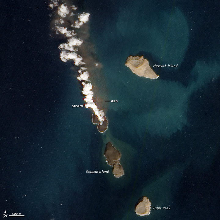
English: New volcanic island in the Red Sea. A new island is forming in the Red Sea. About 60 kilometers (40 miles) from the coast of Yemen, an undersea eruption began in mid-December 2011. Local fishermen reported an eruption near the island of Saba, while satellites captured a white plume rising from the sea, and a pulse of sulfor dioxide. The activity was located on the northern edge of the Zubair Islands . |
|||||
| Date | acquired January 7, 2012 | |||||
| Source | http://earthobservatory.nasa.gov/NaturalHazards/view.php?id=76911 | |||||
| Author | NASA Advanced Land Imager (ALI) aboard the Earth Observing-1 (EO-1) satellite. | |||||
| Permission (Reusing this file) |
|

File history
Click on a date/time to view the file as it appeared at that time.
| Date/Time | Thumbnail | Dimensions | User | Comment | |
|---|---|---|---|---|---|
| current | 17:51, 24 January 2012 | | 720 × 720 (126 KB) | Tillman (talk | contribs) | {{Information |Description ={{en|1=New Volcanic Island in the Red Sea. A new island is forming in the Red Sea. About 60 kilometers (40 miles) from the coast of Yemen, an undersea eruption began in mid-December 2011. Local fishermen reported an eruption |
You cannot overwrite this file.
File usage on Commons
The following page uses this file:
File usage on other wikis
The following other wikis use this file:
- Usage on ar.wikipedia.org
- Usage on arz.wikipedia.org
- Usage on de.wikipedia.org
- Usage on en.wikipedia.org
- Usage on he.wikipedia.org
- Usage on it.wikipedia.org
- Usage on ja.wikipedia.org
- Usage on nn.wikipedia.org
- Usage on pt.wikipedia.org
- Usage on ru.wikipedia.org
- Usage on uk.wikipedia.org
- Usage on www.wikidata.org
- Usage on zh.wikipedia.org