File:Zonas Abono Transportes Madrid.svg
Jump to navigation
Jump to search

Size of this PNG preview of this SVG file: 531 × 600 pixels. Other resolutions: 212 × 240 pixels | 425 × 480 pixels | 680 × 768 pixels | 907 × 1,024 pixels | 1,813 × 2,048 pixels.
Original file (SVG file, nominally 680 × 768 pixels, file size: 346 KB)
Captions
Captions
Add a one-line explanation of what this file represents
Summary[edit]
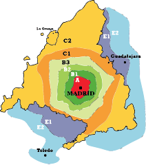
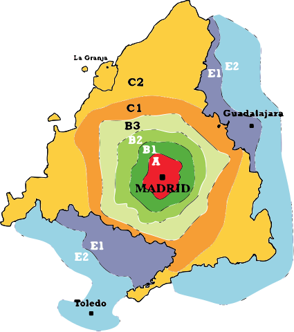
| Description | Este mapa no debe ser usado para cálculos detallados al no representar milimétricamente la geografía de Madrid. |
| Date | 3 August 2006 (original upload date) |
| Source | No machine-readable source provided. Own work assumed (based on copyright claims). |
| Author | No machine-readable author provided. Benedicto16 assumed (based on copyright claims). |
| SVG development | and with Inkscape. This bad Adobe SVG map is very large because Benedicto16 kept the superfluous Adobe PGF or other CDATA garbage . |

Licensing[edit]
| I, the copyright holder of this work, release this work into the public domain. This applies worldwide. In some countries this may not be legally possible; if so: I grant anyone the right to use this work for any purpose, without any conditions, unless such conditions are required by law. |
File history
Click on a date/time to view the file as it appeared at that time.
| Date/Time | Thumbnail | Dimensions | User | Comment | |
|---|---|---|---|---|---|
| current | 11:04, 10 September 2023 | | 680 × 768 (346 KB) | PatriaDeTodos (talk | contribs) | El municipio segoviano del Real Sitio de San Ildefonso -La Granja- está incluido en la línea C-9 de cercanías, en la zona C2 |
| 16:46, 25 February 2008 |  | 372 × 420 (1.03 MB) | Javitomad (talk | contribs) | Añado "Madrid" escrito. | |
| 10:39, 3 August 2006 |  | 372 × 420 (1.02 MB) | Benedicto16 (talk | contribs) | ||
| 10:33, 3 August 2006 |  | 1,486 × 1,677 (960 KB) | Benedicto16 (talk | contribs) | ||
| 10:23, 3 August 2006 |  | 1,486 × 1,677 (145 KB) | Benedicto16 (talk | contribs) | Este mapa no debe ser usado para cálculos detallados al no representar milimétricamente la geografía de Madrid. |
You cannot overwrite this file.
File usage on Commons
The following 5 pages use this file:
File usage on other wikis
The following other wikis use this file:
- Usage on ast.wikipedia.org
- Usage on en.wikipedia.org
- Usage on eo.wikipedia.org
- Usage on es.wikipedia.org
- Usage on fr.wikipedia.org
- Usage on ga.wikipedia.org
- Usage on he.wikipedia.org
- Usage on it.wikipedia.org
- Usage on ja.wikipedia.org
- Usage on kk.wikipedia.org
- Usage on pl.wikipedia.org
- Usage on pt.wikipedia.org
- Usage on ru.wikipedia.org
- Usage on sk.wikipedia.org
- Usage on www.wikidata.org
- Usage on zh.wikipedia.org