File:Zambia districts 2020.svg
Jump to navigation
Jump to search

Size of this PNG preview of this SVG file: 766 × 600 pixels. Other resolutions: 307 × 240 pixels | 613 × 480 pixels | 981 × 768 pixels | 1,280 × 1,002 pixels | 2,560 × 2,004 pixels | 907 × 710 pixels.
Original file (SVG file, nominally 907 × 710 pixels, file size: 3.57 MB)
Captions
Captions
Add a one-line explanation of what this file represents
Summary[edit]
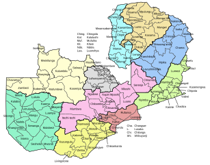
| Description |
Čeština: Okresy a provincie Zambie v roce 2020
Deutsch: Distrikte und Provinzen Sambias im Jahr 2020.
English: Districts and provinces of Zambia in 2020
Français : Districts et provinces de la Zambie en 2020
Polski: Dystrykty i prowincje Zambii w 2020 r.
Português: Distritos e províncias da Zâmbia em 2020
Русский: Районы и провинции Замбии в 2020 году |
||
| Date | |||
| Source | Zambia - Subnational Administrative Boundaries, UNOCHA | ||
| Author | Furfur | ||
| Permission (Reusing this file) |
I, the copyright holder of this work, hereby publish it under the following licenses:
This file is licensed under the Creative Commons Attribution-Share Alike 4.0 International license.
You may select the license of your choice. |
||
| SVG development | This map was created with Adobe Illustrator. |

File history
Click on a date/time to view the file as it appeared at that time.
| Date/Time | Thumbnail | Dimensions | User | Comment | |
|---|---|---|---|---|---|
| current | 22:41, 1 September 2022 | | 907 × 710 (3.57 MB) | Furfur (talk | contribs) | +Lusangazi |
| 21:55, 1 September 2022 |  | 907 × 710 (3.53 MB) | Furfur (talk | contribs) | Luapula -> Mwense | |
| 16:16, 27 August 2022 |  | 907 × 710 (3.53 MB) | Furfur (talk | contribs) | correction Shibuyunji | |
| 04:14, 21 August 2021 |  | 512 × 401 (7.06 MB) | Furfur (talk | contribs) | == {{int:filedesc}} == {{Information |Description={{User:Medium69/Traduction}} {{de|1=Distrikte und Provinzen Sambias im Jahr 2020.}} {{en|1=Districts and provinces of Zambia in 2020}} |Source=[https://data.humdata.org/dataset/zambia-administrative-boundaries-level-1-provinces-and-level-2-districts-with-census-2010-population Zambia - Subnational Administrative Boundaries], UNOCHA |Date=2021-08-21 |Author={{U|Furfur}} |Permission={{self|GFDL|cc-by-sa-4.0}} |Other versions= |Other fields={{Ige... |
You cannot overwrite this file.
File usage on Commons
There are no pages that use this file.