File:Zakynthos municipalities numbered.png
Jump to navigation
Jump to search

Size of this preview: 394 × 599 pixels. Other resolutions: 158 × 240 pixels | 600 × 912 pixels.
Original file (600 × 912 pixels, file size: 30 KB, MIME type: image/png)
Captions
Captions
Add a one-line explanation of what this file represents
Summary[edit]
| Description |
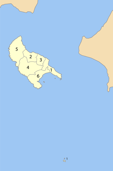
Map of Zakynthos prefecture (Greece) with administrative divisions (municipalities and communities) numbered in alphabetical order (in greek). Legend:
|
| Date | |
| Source | Own work |
| Author | Pitichinaccio |
Licensing[edit]
| I, the copyright holder of this work, release this work into the public domain. This applies worldwide. In some countries this may not be legally possible; if so: I grant anyone the right to use this work for any purpose, without any conditions, unless such conditions are required by law. |
File history
Click on a date/time to view the file as it appeared at that time.
| Date/Time | Thumbnail | Dimensions | User | Comment | |
|---|---|---|---|---|---|
| current | 17:09, 1 September 2007 | | 600 × 912 (30 KB) | Pitichinaccio (talk | contribs) | {{Information |Description=Map of Zakynthos prefecture (Greece) with administrative divisions (municipalities and communities) numbered in alphabetical order (in greek). Legend: * 1. Δήμος Ζακυνθίων - Zakynthos * 2. Δήμος Αλυκών |
You cannot overwrite this file.
File usage on Commons
There are no pages that use this file.
File usage on other wikis
The following other wikis use this file:
- Usage on de.wikipedia.org
- Usage on el.wikipedia.org
- Usage on es.wikipedia.org
- Usage on gl.wikipedia.org
- Usage on hr.wikipedia.org
- Usage on hu.wikipedia.org
- Usage on hyw.wikipedia.org
- Usage on it.wikipedia.org
- Usage on ja.wikipedia.org
- Usage on ko.wikipedia.org
- Usage on la.wikipedia.org
- Usage on lt.wikipedia.org
- Usage on pt.wikipedia.org