File:ZIP code zones.png
Jump to navigation
Jump to search
Size of this preview: 800 × 564 pixels. Other resolutions: 320 × 226 pixels | 640 × 451 pixels | 976 × 688 pixels.
Original file (976 × 688 pixels, file size: 182 KB, MIME type: image/png)
Captions
Captions
Add a one-line explanation of what this file represents
| Description |
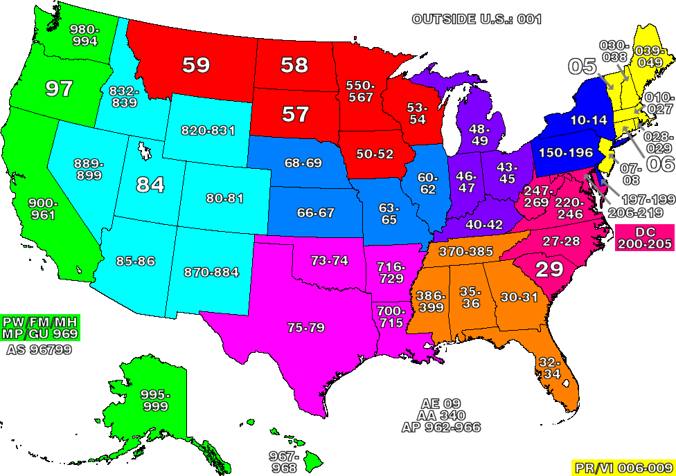
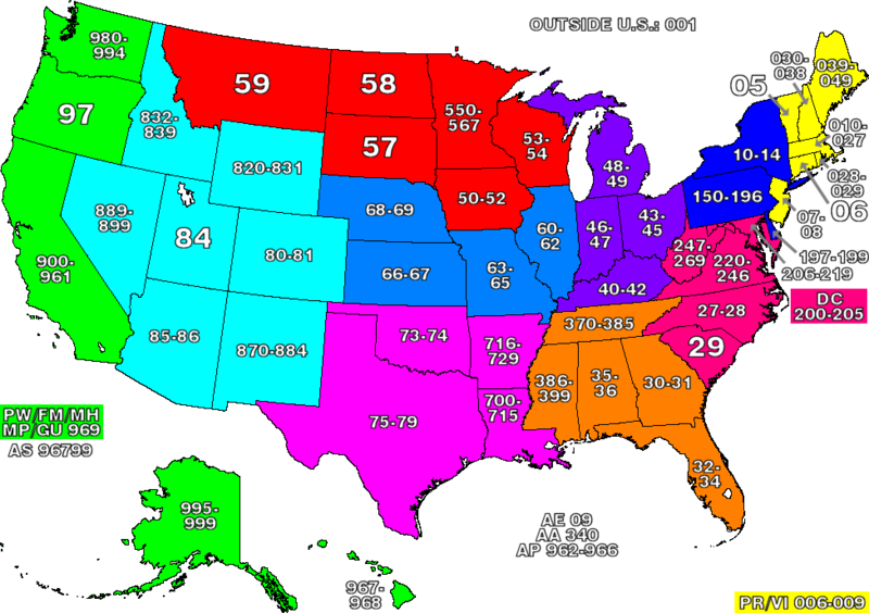
This map of the United States divides the country into ZIP code zones. All states with a common colour use ZIP codes starting with the same digit. Where only two digits are used, the allocation reflects all existing ZIP codes starting with those two digits. Nederlands: ZIP code gebieden in de Verenigde Staten
中文:圖示美國各州的郵區編號,字頭相同的州份會以相同顏色表示。 |
| Source | Own work |
| Author | denelson83 |
| Permission (Reusing this file) |
GNU-FDL |

|
Permission is granted to copy, distribute and/or modify this document under the terms of the GNU Free Documentation License, Version 1.2 or any later version published by the Free Software Foundation; with no Invariant Sections, no Front-Cover Texts, and no Back-Cover Texts. A copy of the license is included in the section entitled GNU Free Documentation License. |
| This file is licensed under the Creative Commons Attribution-Share Alike 3.0 Unported license. | ||
| ||
| This licensing tag was added to this file as part of the GFDL licensing update. |

|
File:ZIP Code zones.svg is a vector version of this file. It should be used in place of this PNG file when not inferior.
File:ZIP code zones.png → File:ZIP Code zones.svg
For more information, see Help:SVG. |
 |
File history
Click on a date/time to view the file as it appeared at that time.
| Date/Time | Thumbnail | Dimensions | User | Comment | |
|---|---|---|---|---|---|
| current | 03:48, 8 June 2005 | | 976 × 688 (182 KB) | Denelson83 (talk | contribs) | More accurate |
| 20:35, 1 June 2005 |  | 976 × 688 (197 KB) | Jacob Buerk (talk | contribs) | Reverted to earlier revision | |
| 23:39, 11 March 2005 |  | 976 × 688 (180 KB) | Denelson83 (talk | contribs) | A few improvements | |
| 05:35, 27 February 2005 |  | 976 × 688 (176 KB) | Denelson83 (talk | contribs) | More visible number ranges | |
| 02:57, 26 February 2005 |  | 976 × 688 (197 KB) | Denelson83 (talk | contribs) | This map of the United States divides the country into ZIP code zones. All states with a common colour use ZIP codes starting with the same digit. Created by denelson83. {{GFDL}} |
You cannot overwrite this file.
File usage on Commons
There are no pages that use this file.
File usage on other wikis
The following other wikis use this file:
- Usage on bg.wikipedia.org
- Usage on en.wikipedia.org
- Usage on eo.wikipedia.org
- Usage on he.wikipedia.org
- Usage on he.wiktionary.org
- Usage on hu.wikipedia.org
- Usage on ja.wikipedia.org
- Usage on nl.wikipedia.org
- Usage on pl.wikipedia.org
- Usage on zh.wikipedia.org