File:Yeonpyeong residential area ja.svg
Jump to navigation
Jump to search

Size of this PNG preview of this SVG file: 415 × 329 pixels. Other resolutions: 303 × 240 pixels | 606 × 480 pixels | 969 × 768 pixels | 1,280 × 1,015 pixels | 2,560 × 2,029 pixels.
Original file (SVG file, nominally 415 × 329 pixels, file size: 582 KB)
Captions
Captions
Add a one-line explanation of what this file represents
Summary[edit]
| Description |
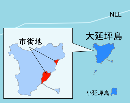
English: Big Yeonpyeong Island residential area
日本語: 大延坪島の市街地 |
| Date | |
| Source | Own work |
| Author | Kellykaneshiro |
| Other versions |
|
| SVG development |


Licensing[edit]
I, the copyright holder of this work, hereby publish it under the following licenses:
This file is licensed under the Creative Commons Attribution-Share Alike 3.0 Unported license.
- You are free:
- to share – to copy, distribute and transmit the work
- to remix – to adapt the work
- Under the following conditions:
- attribution – You must give appropriate credit, provide a link to the license, and indicate if changes were made. You may do so in any reasonable manner, but not in any way that suggests the licensor endorses you or your use.
- share alike – If you remix, transform, or build upon the material, you must distribute your contributions under the same or compatible license as the original.

|
Permission is granted to copy, distribute and/or modify this document under the terms of the GNU Free Documentation License, Version 1.2 or any later version published by the Free Software Foundation; with no Invariant Sections, no Front-Cover Texts, and no Back-Cover Texts. A copy of the license is included in the section entitled GNU Free Documentation License. |
You may select the license of your choice.
File history
Click on a date/time to view the file as it appeared at that time.
| Date/Time | Thumbnail | Dimensions | User | Comment | |
|---|---|---|---|---|---|
| current | 20:36, 26 November 2010 | | 415 × 329 (582 KB) | Kellykaneshiro (talk | contribs) | resized |
| 02:56, 24 November 2010 |  | 416 × 485 (575 KB) | Kellykaneshiro (talk | contribs) | ammended southen part of the island. 南部欠落部修正 | |
| 02:34, 24 November 2010 |  | 416 × 485 (531 KB) | Kellykaneshiro (talk | contribs) | {{Information |Description={{en|1=Big Yeonpyeong Island residential area}} {{ja|1=大延坪島の市街地}} |Source={{own}} |Author=Kellykaneshiro |Date=2010-11-24 |Permission= |other_versions=File:Yeonpyeong residential area.svg }} [[Category:Map of Ko |
You cannot overwrite this file.
File usage on Commons
The following page uses this file: