File:Yacimiento arqueológico de Lancia 03 - by smart-drone.es.jpg
Jump to navigation
Jump to search

Size of this preview: 800 × 534 pixels. Other resolutions: 320 × 214 pixels | 640 × 427 pixels | 944 × 630 pixels.
Original file (944 × 630 pixels, file size: 783 KB, MIME type: image/jpeg)
Captions
Captions
Add a one-line explanation of what this file represents
Summary[edit]
| Description |
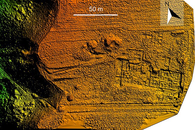
Español: Modelo digital de elevación (MDE) o modelo digital del terreno (MDT) del yacimiento arqueológico de Lancia, Villasabariego (León, España) |
| Date | |
| Source | Taken and performed by Smart Drone, SL, Spain |
| Author | smart-drone.es |
| Permission (Reusing this file) |
| Camera location | | View this and other nearby images on: OpenStreetMap |
|---|
Licensing[edit]
I, the copyright holder of this work, hereby publish it under the following licenses:

|
Permission is granted to copy, distribute and/or modify this document under the terms of the GNU Free Documentation License, Version 1.2 or any later version published by the Free Software Foundation; with no Invariant Sections, no Front-Cover Texts, and no Back-Cover Texts. A copy of the license is included in the section entitled GNU Free Documentation License. |
This file is licensed under the Creative Commons Attribution 4.0 International license.
- You are free:
- to share – to copy, distribute and transmit the work
- to remix – to adapt the work
- Under the following conditions:
- attribution – You must give appropriate credit, provide a link to the license, and indicate if changes were made. You may do so in any reasonable manner, but not in any way that suggests the licensor endorses you or your use.
You may select the license of your choice.
File history
Click on a date/time to view the file as it appeared at that time.
| Date/Time | Thumbnail | Dimensions | User | Comment | |
|---|---|---|---|---|---|
| current | 09:54, 13 April 2022 | | 944 × 630 (783 KB) | David Perez (talk | contribs) | Uploaded a work by smart-drone.es from Taken and performed by Smart Drone, SL, Spain with UploadWizard |
You cannot overwrite this file.
File usage on Commons
The following page uses this file: