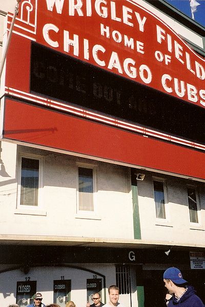
File:Wrigley Field, Chicago, Illinois (2519934881).jpg

Original file (762 × 1,143 pixels, file size: 482 KB, MIME type: image/jpeg)
Captions
Captions
Summary[edit]
| DescriptionWrigley Field, Chicago, Illinois (2519934881).jpg |
Wrigley Field is a baseball venue located in Chicago, Illinois, United States that has served as the home ballpark of the Chicago Cubs since 1916. It was built in 1914 as Weeghman Park for the Chicago Federal League baseball team, the Chicago Whales. It was called Cubs Park between 1920 and 1926 before being renamed for then Cubs team owner and chewing gum magnate, William Wrigley, Jr.. Between 1921 and 1970, it was also the home of the Chicago Bears of the National Football League. It hosted the second annual National Hockey League Winter Classic on January 1, 2009. Located in the community area of Lakeview, Wrigley Field sits on an irregular block bounded by Clark (west) and Addison (south) Streets and Waveland (north) and Sheffield (east) Avenues. The area surrounding the ballpark contains residential streets, in addition to bars, restaurants and other establishments and is called Wrigleyville. The ballpark's mailing address is 1060 W. Addison Street. Wrigley Field is nicknamed The Friendly Confines, a phrase popularized by "Mr. Cub", Hall of Famer Ernie Banks. The current capacity is 41,009,[6] making Wrigley Field the 10th-smallest actively used ballpark. It is the oldest National League ballpark and the second oldest active major league ballpark (after Fenway Park on April 20, 1912), and the only remaining Federal League park. Wrigley is known for its ivy covered brick outfield wall, the unusual wind patterns off Lake Michigan, the iconic red marquee over the main entrance, the hand turned scoreboard, and for being the last major league park to have lights installed for play after dark, with lighting installed in 1988. en.wikipedia.org/wiki/Wrigley_field en.wikipedia.org/wiki/Wikipedia:Text_of_Creative_Commons_... |
| Date | |
| Source | Wrigley Field, Chicago, Illinois |
| Author | Ken Lund from Reno, Nevada, USA |
| Camera location | 41° 56′ 51.02″ N, 87° 39′ 23.63″ W | View this and other nearby images on: OpenStreetMap |
|---|
Licensing[edit]
- You are free:
- to share – to copy, distribute and transmit the work
- to remix – to adapt the work
- Under the following conditions:
- attribution – You must give appropriate credit, provide a link to the license, and indicate if changes were made. You may do so in any reasonable manner, but not in any way that suggests the licensor endorses you or your use.
- share alike – If you remix, transform, or build upon the material, you must distribute your contributions under the same or compatible license as the original.
| This image was originally posted to Flickr by Ken Lund at https://flickr.com/photos/75683070@N00/2519934881. It was reviewed on 2 March 2017 by FlickreviewR and was confirmed to be licensed under the terms of the cc-by-sa-2.0. |
2 March 2017
File history
Click on a date/time to view the file as it appeared at that time.
| Date/Time | Thumbnail | Dimensions | User | Comment | |
|---|---|---|---|---|---|
| current | 02:35, 2 March 2017 |  | 762 × 1,143 (482 KB) | Victorgrigas (talk | contribs) | Transferred from Flickr via Flickr2Commons |
You cannot overwrite this file.
File usage on Commons
There are no pages that use this file.
Metadata
This file contains additional information such as Exif metadata which may have been added by the digital camera, scanner, or software program used to create or digitize it. If the file has been modified from its original state, some details such as the timestamp may not fully reflect those of the original file. The timestamp is only as accurate as the clock in the camera, and it may be completely wrong.
| Camera manufacturer | HP |
|---|---|
| Camera model | HP pst2700 |
| Date and time of data generation | 00:45, 25 May 2008 |
| Horizontal resolution | 200 dpi |
| Vertical resolution | 200 dpi |
| Y and C positioning | Co-sited |
| Pair of black and white reference values |
|
| Exif version | 2.2 |
| Meaning of each component |
|
| Supported Flashpix version | 1 |
| Color space | sRGB |
| Saturation | Normal |
| Sharpness | Normal |