File:World topo 5layers.svg
Jump to navigation
Jump to search

Size of this PNG preview of this SVG file: 772 × 293 pixels. Other resolutions: 320 × 121 pixels | 640 × 243 pixels | 1,024 × 389 pixels | 1,280 × 486 pixels | 2,560 × 972 pixels.
Original file (SVG file, nominally 772 × 293 pixels, file size: 1.16 MB)
Captions
Captions
Add a one-line explanation of what this file represents
Summary[edit]
| Description |
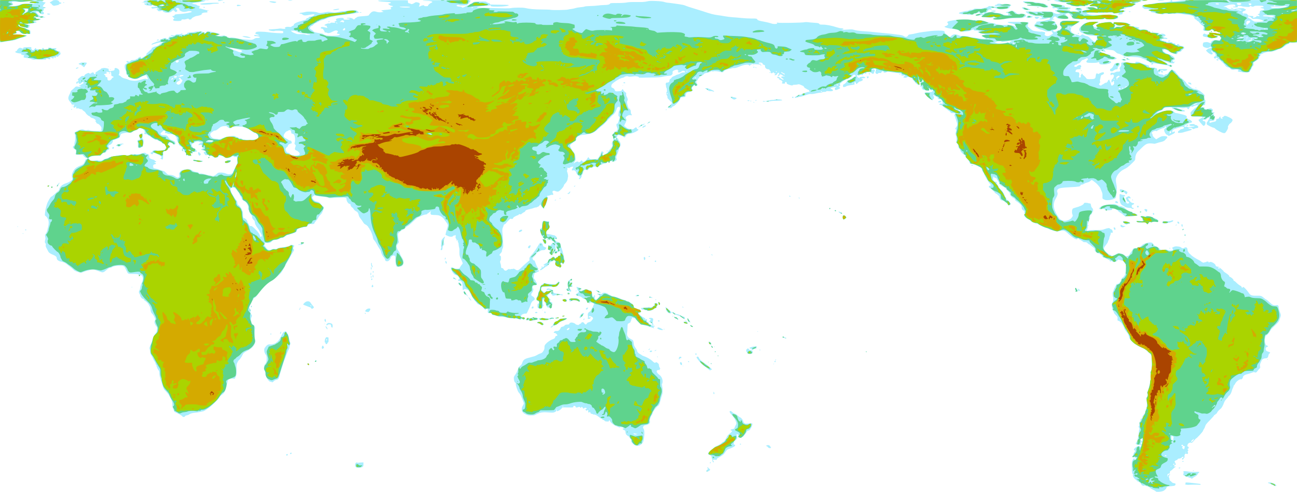
English: simple world map in equirectangular projection, longitude 30 W to 30 W, latitude 80 N to 60 S,
with five layers based on elevation ("bedrock" dataset, i.e. Greenland shown as if ice-free):
|
| Date | |
| Source | self-made, using ETOPO1 data, GMT and inkscape |
| Author | User:Dbachmann |
| Other versions |
 |
Licensing[edit]
I, the copyright holder of this work, hereby publish it under the following licenses:

|
Permission is granted to copy, distribute and/or modify this document under the terms of the GNU Free Documentation License, Version 1.2 or any later version published by the Free Software Foundation; with no Invariant Sections, no Front-Cover Texts, and no Back-Cover Texts. A copy of the license is included in the section entitled GNU Free Documentation License. |
This file is licensed under the Creative Commons Attribution-Share Alike Attribution-Share Alike 4.0 International, 3.0 Unported, 2.5 Generic, 2.0 Generic and 1.0 Generic license.
- You are free:
- to share – to copy, distribute and transmit the work
- to remix – to adapt the work
- Under the following conditions:
- attribution – You must give appropriate credit, provide a link to the license, and indicate if changes were made. You may do so in any reasonable manner, but not in any way that suggests the licensor endorses you or your use.
- share alike – If you remix, transform, or build upon the material, you must distribute your contributions under the same or compatible license as the original.
You may select the license of your choice.
File history
Click on a date/time to view the file as it appeared at that time.
| Date/Time | Thumbnail | Dimensions | User | Comment | |
|---|---|---|---|---|---|
| current | 12:07, 8 September 2018 | 772 × 293 (1.16 MB) | Dbachmann (talk | contribs) | ||
| 06:55, 8 September 2018 | 300 × 112 (1.57 MB) | Dbachmann (talk | contribs) | {{Information |description ={{en|1=simple world map in equirectangular projection, with five layers based on elevation ("bedrock" dataset, i.e. Greenland shown as if ice-free) 1. "shallow water", -60m to 0m 2. lowlands, 0m to 250m 3. hills, 250m to 1000m 4. mountains, 1000m to 3000m 5. high mountains, above 3000m }} |date =2018 |source =self-made, using ETOPO1 data, GMT and inkscape |author =User:Dbachmann }} Category:Elevation maps of the world |
You cannot overwrite this file.
File usage on Commons
The following page uses this file: