File:World Soil pH.svg
Jump to navigation
Jump to search

Size of this PNG preview of this SVG file: 800 × 406 pixels. Other resolutions: 320 × 162 pixels | 640 × 325 pixels | 1,024 × 520 pixels | 1,280 × 650 pixels | 2,560 × 1,299 pixels | 940 × 477 pixels.
Original file (SVG file, nominally 940 × 477 pixels, file size: 6.43 MB)
Captions
Captions
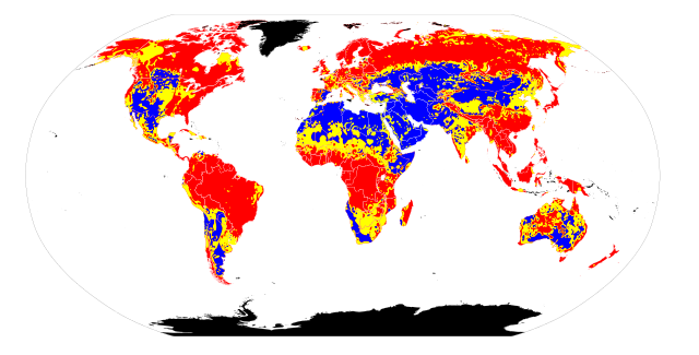
A map of soil pH showing acidic soils in red, neutral soils in yellow, and basic soils in blue.
Summary[edit]
| Description |
English: I retrieved the soil pH maps from [1]. In GIMP 2.4.3 I used the "Select by Color Tool" (threshold 15.0) to create pH-specific maps. Note that the original maps do not indicate actual pH values in the pH scale. For soils with acidic pH, I included the colors indicated by the leftmost 14 bars in the pH scale, ranging from red to pink. For soils with basic pH, I included the colors indicated by the rightmost 6 bars on the pH scale, ranging from light blue to blue. For soils with neutral pH, I included the remainder of the bars on the pH scale, which included very light pink, white, and very light blue. I then referenced these pH-specific maps to draw regions of differing soil pH on File:BlankMap-World6.svg. Because the original maps from Atlas of the Biosphere and File:BlankMap-World6.svg use different map projections, some ambiguity was introduced into this map. Thus it can only be taken to represent basic trends in soil pH, not precise boundaries.
|
|
| Date | ||
| Source | Own work | |
| Author | Ninjatacoshell |
Licensing[edit]
I, the copyright holder of this work, hereby publish it under the following licenses:
This file is licensed under the Creative Commons Attribution-Share Alike 3.0 Unported license.
- You are free:
- to share – to copy, distribute and transmit the work
- to remix – to adapt the work
- Under the following conditions:
- attribution – You must give appropriate credit, provide a link to the license, and indicate if changes were made. You may do so in any reasonable manner, but not in any way that suggests the licensor endorses you or your use.
- share alike – If you remix, transform, or build upon the material, you must distribute your contributions under the same or compatible license as the original.

|
Permission is granted to copy, distribute and/or modify this document under the terms of the GNU Free Documentation License, Version 1.2 or any later version published by the Free Software Foundation; with no Invariant Sections, no Front-Cover Texts, and no Back-Cover Texts. A copy of the license is included in the section entitled GNU Free Documentation License. |
You may select the license of your choice.
File history
Click on a date/time to view the file as it appeared at that time.
| Date/Time | Thumbnail | Dimensions | User | Comment | |
|---|---|---|---|---|---|
| current | 06:16, 14 May 2010 | | 940 × 477 (6.43 MB) | Ninjatacoshell (talk | contribs) | {{Information |Description={{en|1=I retrieved the soil pH maps from [http://www.sage.wisc.edu/atlas/maps.php?datasetid=20&includerelatedlinks=1&dataset=20 Atlas of the Biosphere]. In GIMP 2.4.3 I used the "Select by Color Tool" (threshold 15.0) to create |
You cannot overwrite this file.
File usage on Commons
The following page uses this file:
File usage on other wikis
The following other wikis use this file:
- Usage on ar.wikipedia.org
- Usage on bg.wikipedia.org
- Usage on bn.wikipedia.org
- Usage on ca.wikipedia.org
- Usage on de.wikipedia.org
- Usage on en.wikipedia.org
- Usage on eo.wikipedia.org
- Usage on es.wikipedia.org
- Usage on fa.wikipedia.org
- Usage on fr.wikipedia.org
- Usage on hi.wikipedia.org
- Usage on hy.wikipedia.org
- Usage on la.wikipedia.org
- Usage on mn.wikipedia.org
- Usage on nl.wikipedia.org
- Usage on pt.wikipedia.org
- Usage on uk.wikipedia.org
- Usage on vi.wikipedia.org
- Usage on zh.wikipedia.org