File:Western sahara walls moroccan map-es.svg
Jump to navigation
Jump to search

Size of this PNG preview of this SVG file: 772 × 600 pixels. Other resolutions: 309 × 240 pixels | 618 × 480 pixels | 989 × 768 pixels | 1,280 × 994 pixels | 2,560 × 1,989 pixels | 1,676 × 1,302 pixels.
Original file (SVG file, nominally 1,676 × 1,302 pixels, file size: 193 KB)
Captions
Captions
Add a one-line explanation of what this file represents
Summary[edit]
| Description |
[]
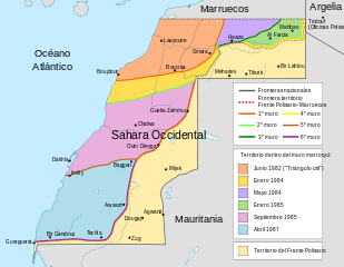
Deutsch: Karte des Marokkanischen Walls in der Westsahara. Er wurde in sechs Etappen in den 1980er Jahren errichtet, wie in der Karte dargestellt. Ebenfalls dargestellt ist das Polisario-Territorium und die Konfliktzone aus dem November 2020 (ermittelt anhand OSM). English: Map of the Moroccan Wall in Western Sahara - built over several stages, shows the six walls built, & when the territory was behind Moroccan wall. Also shows Polisario held territory who are based in Algeria (seen at top right). Euskara: Mendebaldeko Saharako harresien mapa العربية : خريطة الجدار الرملي المغربي في الصحراء الغربية |
||
| Date | (UTC) | ||
| Source | |||
| Author |
|
||
| Other versions |
[]
|


| This is a retouched picture, which means that it has been digitally altered from its original version. Modifications: spanish. The original can be viewed here: Western sahara walls moroccan map-en.svg:
|
Licensing[edit]
I, the copyright holder of this work, hereby publish it under the following license:
This file is licensed under the Creative Commons Attribution-Share Alike 3.0 Unported license.
- You are free:
- to share – to copy, distribute and transmit the work
- to remix – to adapt the work
- Under the following conditions:
- attribution – You must give appropriate credit, provide a link to the license, and indicate if changes were made. You may do so in any reasonable manner, but not in any way that suggests the licensor endorses you or your use.
- share alike – If you remix, transform, or build upon the material, you must distribute your contributions under the same or compatible license as the original.
Original upload log[edit]
This image is a derivative work of the following images:
- File:Western_sahara_walls_moroccan_map-en.svg licensed with Cc-by-sa-3.0
- 2011-08-19T17:00:33Z M0tty 1676x1302 (197156 Bytes) corr color legend
- 2011-08-17T09:01:54Z M0tty 1676x1302 (197399 Bytes) corr legend
- 2011-08-16T18:46:57Z M0tty 1676x1302 (194768 Bytes) {{Information |Description={{en|Map of the [[w:Moroccan Wall]] in [[w:Western Sahara]] - built over several stages, shows the six walls built, & when the territory was behind Moroccan wall. Also shows polisaro held territory
Uploaded with derivativeFX
File history
Click on a date/time to view the file as it appeared at that time.
| Date/Time | Thumbnail | Dimensions | User | Comment | |
|---|---|---|---|---|---|
| current | 19:40, 29 November 2011 | | 1,676 × 1,302 (193 KB) | Robot8A (talk | contribs) | == {{int:filedesc}} == {{Information |Description={{en|Map of the w:Moroccan Wall in w:Western Sahara - built over several stages, shows the six walls built, & when the territory was behind Moroccan wall. Also shows polisaro held territory who are |
You cannot overwrite this file.
File usage on Commons
The following 10 pages use this file:
- File:Western sahara walls moroccan.png
- File:Western sahara walls moroccan map-ar.svg
- File:Western sahara walls moroccan map-de.svg
- File:Western sahara walls moroccan map-en.svg
- File:Western sahara walls moroccan map-es.svg
- File:Western sahara walls moroccan map-eu.svg
- File:Western sahara walls moroccan map-fr.svg
- Template:Other versions/Western Sahara walls map
- Category:Bu Craa
- Category:Guerguerat
File usage on other wikis
The following other wikis use this file:
- Usage on ar.wikipedia.org
- Usage on arz.wikipedia.org
- Usage on ast.wikipedia.org
- Usage on ca.wikipedia.org
- Usage on de.wikipedia.org
- Usage on en.wikipedia.org
- Usage on eo.wikipedia.org
- Usage on es.wikipedia.org
- Sahara Occidental
- Muro marroquí
- Hasán II de Marruecos
- Estatus político del Sahara Occidental
- República Árabe Saharaui Democrática
- Invasión marroquí del Sahara español
- Historia de Marruecos
- Acuerdo Tripartito de Madrid
- Descolonización
- Historia del Sahara Occidental
- Guerguerat
- Hagunia
- Zug (Sahara Occidental)
- Bucraa
- Guerra del Sahara Occidental
- Zona Libre
- Ocupación marroquí del Sahara Occidental
- Frontera entre Argelia y Sahara Occidental
- Frontera entre Marruecos y Sahara Occidental
- Conflicto del Sahara Occidental
- Enfrentamientos del Sahara Occidental (2020-presente)
- Acuerdo de normalización de las relaciones entre Israel y Marruecos
- Usage on eu.wikipedia.org
- Usage on ha.wikipedia.org
- Usage on ig.wikipedia.org
- Usage on ms.wikipedia.org
- Usage on pt.wikipedia.org
- Usage on sw.wikipedia.org
View more global usage of this file.