File:Western Cape, South Africa.jpg

Original file (3,508 × 2,546 pixels, file size: 2.24 MB, MIME type: image/jpeg)
Captions
Captions
Summary[edit]
| Description |
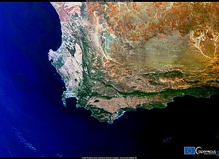
English: Africa is amongst the continents most vulnerable to climate change. Aside from the resultant environmental damage, the temperature rise by itself could negatively affect economic productivity in the coming years. According to a recent study coordinated by the CMCC Foundation and the European Institute on Economics and the Environment (RFF-CMCC), in South Africa climate change could lead to a reduction in GDP per capita of up to 20% by the end of this century, as compared to an idealised scenario without any of its impacts. This image, acquired by one of the Copernicus Sentinel-3 satellites on 2 February 2021, shows the Western Cape province of South Africa. Between 2015 and 2018, this area faced one of the worst droughts to have impacted the country. Scientists attribute the water scarcity in the region to the increasingly severe effects of climate change. Open Data supplied by the Copernicus Sentinel satellites and services allow for the monitoring of the impacts of climate change around the world. |
| Date | Taken on 2 February 2021 |
| Source | Western Cape, South Africa |
| Author | European Union , Copernicus Sentinel-3 imagery |
Licensing[edit]

|
This image contains data from a satellite in the Copernicus Programme, such as Sentinel-1, Sentinel-2 or Sentinel-3. Attribution is required when using this image.
Attribution: Contains modified Copernicus Sentinel data 2021
The use of Copernicus Sentinel Data is regulated under EU law (Commission Delegated Regulation (EU) No 1159/2013 and Regulation (EU) No 377/2014). Relevant excerpts:
Free access shall be given to GMES dedicated data [...] made available through GMES dissemination platforms [...].
Access to GMES dedicated data [...] shall be given for the purpose of the following use in so far as it is lawful:
GMES dedicated data [...] may be used worldwide without limitations in time.
GMES dedicated data and GMES service information are provided to users without any express or implied warranty, including as regards quality and suitability for any purpose. |
File history
Click on a date/time to view the file as it appeared at that time.
| Date/Time | Thumbnail | Dimensions | User | Comment | |
|---|---|---|---|---|---|
| current | 18:53, 26 August 2023 | | 3,508 × 2,546 (2.24 MB) | OptimusPrimeBot (talk | contribs) | #Spacemedia - Upload of https://www.copernicus.eu/system/files/2021-02/image_day/SouthAfricaS3.jpg via Commons:Spacemedia |
You cannot overwrite this file.
File usage on Commons
There are no pages that use this file.