File:West Germanic dialect continuum in 1900 (according to Wiesinger, Heeringa & König).png
Original file (3,748 × 3,044 pixels, file size: 1.31 MB, MIME type: image/png)
Captions
Captions
Summary[edit]
.png&action=edit§ion=1)
| Description |
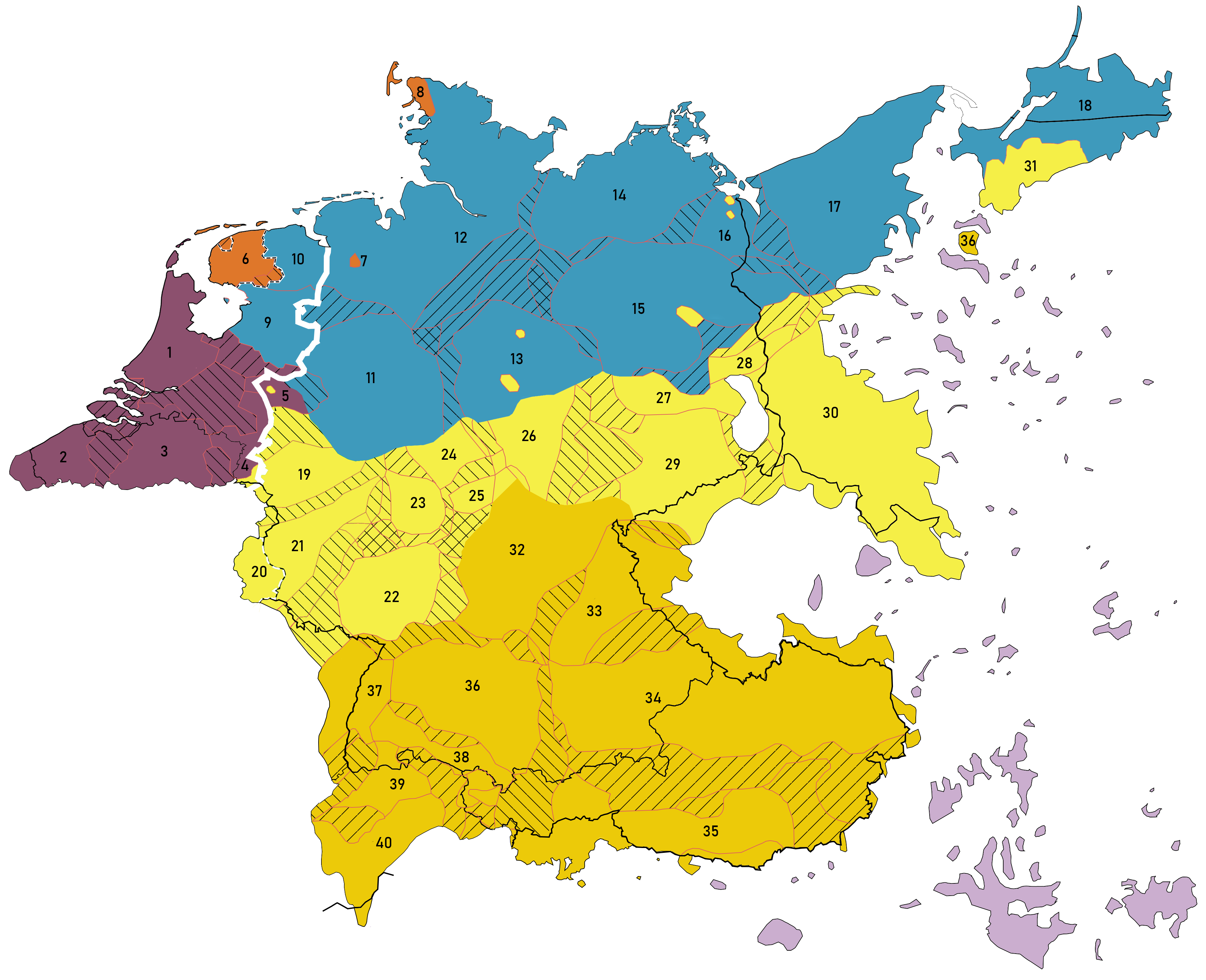
English: A map describing the principal dialect groupings of the closed West Germanic dialect continuum between German, Frisian, Low Franconian / Netherlandic and Low German around the year 1900. Based on:
Legend: Lines
Low Franconian varieties: (purple) Frisian varieties: (orange) Low German varieties: (blue) Middle/Central German varieties: (yellow) Note 1: The empty part near 25, 26, 27 isn't a lake but Sorbian, a Slavic variety. Upper German varieties: (ochre) German language pockets in Eastern and Southern Europe: (lila) Cp.:
|
| Date | |
| Source | Own work |
| Author | Vlaemink |
.png)
.png)
.png)
.png)
Licensing[edit]
.png&action=edit§ion=2)
- You are free:
- to share – to copy, distribute and transmit the work
- to remix – to adapt the work
- Under the following conditions:
- attribution – You must give appropriate credit, provide a link to the license, and indicate if changes were made. You may do so in any reasonable manner, but not in any way that suggests the licensor endorses you or your use.
- share alike – If you remix, transform, or build upon the material, you must distribute your contributions under the same or compatible license as the original.
File history
Click on a date/time to view the file as it appeared at that time.
| Date/Time | Thumbnail | Dimensions | User | Comment | |
|---|---|---|---|---|---|
| current | 13:23, 19 November 2021 | | 3,748 × 3,044 (1.31 MB) | Vlaemink (talk | contribs) | Bildts is closer to Frisian than Hollandic per Heeroma |
| 10:59, 19 November 2021 |  | 3,748 × 3,044 (1.31 MB) | Vlaemink (talk | contribs) | Uploaded own work with UploadWizard |
You cannot overwrite this file.
File usage on Commons
The following page uses this file:
.png&redirect=no)
File usage on other wikis
The following other wikis use this file:
- Usage on de.wikipedia.org
- Usage on nl.wikipedia.org
.png&oldid=845231932)