File:Weltkarte konventionelle Öl u. -Gasförderung.png
Jump to navigation
Jump to search
Size of this preview: 800 × 434 pixels. Other resolutions: 320 × 174 pixels | 640 × 348 pixels | 1,024 × 556 pixels | 1,280 × 695 pixels | 2,000 × 1,086 pixels.
Original file (2,000 × 1,086 pixels, file size: 1.12 MB, MIME type: image/png)
Captions
Captions
Add a one-line explanation of what this file represents
Summary[edit]
| Description |
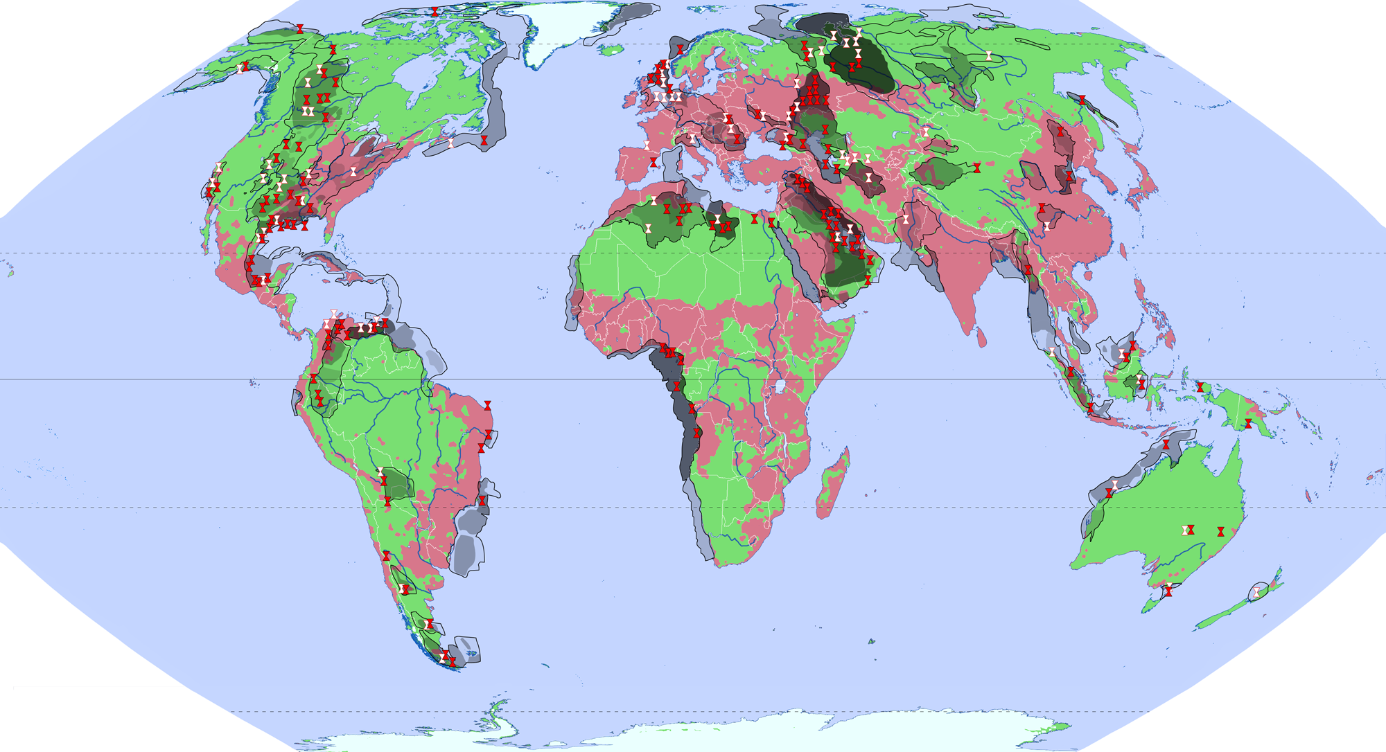
Bekannte konventionelle Erdöl- und Erdgasfelder, sowie Förderung Anfang des 21. Jahrhunderts Legende als Bild wg. Problemen mit Unicode-Zeichen:  |
| Date | |
| Source | Own work |
| Author | Ökologix |
Weitgehende Anpassung der verschiedenen Karten an die Grenzen der Sedimentationsbecken nach United States Geological Survey (USGS)
Quellen[edit]
Kartographie[edit]
- Eckert VI-Projektion (nahezu flächentreu, realistische Größenverhältnisse, relativ wenig verzerrt), erstellt mit geo.dianacht.de (Lizenz CC-BY)
Datengrundlagen[edit]
Konventionelle Erdöl- und Erdgasförderung[edit]
- Karten: Bergbau und Industrie der einzelnen Kontinente im im Alexander-Weltatlas 2000, Klett-Perthes, Gotha 2000
- Fördermengen: Thomas S. Ahlbrandt u. Peter J. McCabe: Global Petroleum Resources: A View to the Future, geotimes.org des American Geological Institute, Alexandria, Virginia, USA
Konventionelle Erdöl- und Erdgasfelder, Sedimentationsbecken[edit]
- Karte (ohne USA?): World Petroleum Assessment 2000 Provinces and total Petroleum Systems, United States Geological Survey (USGS)
- Karte Arktis: Wiki-Karte ArcticLocationMap2.gif
- Karten USA: Oil/Gas plays in North America, PacWest Consulting Partners, Houston, USA -und- Geologic Controls on the Growth of Petroleum Reserves, United States Geological Survey (USGS)
Landschaften[edit]
- angelehnt an die Wikipediakarte Wildnisweltkarte.png, siehe Quellen dort
Licensing[edit]
I, the copyright holder of this work, hereby publish it under the following licenses:

|
Permission is granted to copy, distribute and/or modify this document under the terms of the GNU Free Documentation License, Version 1.2 or any later version published by the Free Software Foundation; with no Invariant Sections, no Front-Cover Texts, and no Back-Cover Texts. A copy of the license is included in the section entitled GNU Free Documentation License. |
This file is licensed under the Creative Commons Attribution 3.0 Unported license.
- You are free:
- to share – to copy, distribute and transmit the work
- to remix – to adapt the work
- Under the following conditions:
- attribution – You must give appropriate credit, provide a link to the license, and indicate if changes were made. You may do so in any reasonable manner, but not in any way that suggests the licensor endorses you or your use.
You may select the license of your choice.
File history
Click on a date/time to view the file as it appeared at that time.
| Date/Time | Thumbnail | Dimensions | User | Comment | |
|---|---|---|---|---|---|
| current | 10:09, 10 January 2014 | | 2,000 × 1,086 (1.12 MB) | Fährtenleser (talk | contribs) | {{Information |Description ={{de|1=Bekannte konventionelle Erdöl- und Erdgasfelder, sowie Förderung Anfang des 21. Jahrhunderts {| | {{Legend|#eafffe|}} | Eisschilde |- | {{Legend|#79df72|}} | Wildnis und weitgehend naturnahe Landschaften („La... |
You cannot overwrite this file.
File usage on Commons
There are no pages that use this file.
File usage on other wikis
The following other wikis use this file:
- Usage on de.wikipedia.org