File:Waterfall-SPB-diagram.gif
Jump to navigation
Jump to search
No higher resolution available.
Waterfall-SPB-diagram.gif (496 × 570 pixels, file size: 55 KB, MIME type: image/gif)
Captions
Captions
Add a one-line explanation of what this file represents

|
This transport map image could be re-created using vector graphics as an SVG file. This has several advantages; see Commons:Media for cleanup for more information. If an SVG form of this image is available, please upload it and afterwards replace this template with
{{vector version available|new image name}}.
It is recommended to name the SVG file “Waterfall-SPB-diagram.svg”—then the template Vector version available (or Vva) does not need the new image name parameter. |
Summary[edit]
| Description |
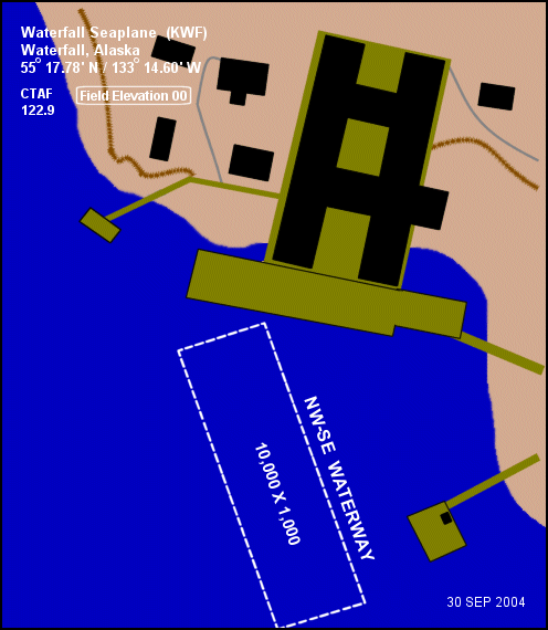
English: Diagram of Waterfall Seaplane Base (FAA: KWF) in Alaska, United States |
| Date | |
| Source |
|
| Author | Federal Aviation Administration, Alaskan Region |
| Permission (Reusing this file) |
Public domain |
| Object location | | View this and other nearby images on: OpenStreetMap |
|---|
Licensing[edit]
This image or file is a work of a Federal Aviation Administration employee, taken or made as part of that person's official duties. As a work of the U.S. federal government, the image is in the public domain in the United States.
|
 |
File history
Click on a date/time to view the file as it appeared at that time.
| Date/Time | Thumbnail | Dimensions | User | Comment | |
|---|---|---|---|---|---|
| current | 00:29, 3 September 2009 | | 496 × 570 (55 KB) | Zyxw (talk | contribs) | == Summary == {{Information |Description=Diagram of {{w|Waterfall Seaplane Base}} (FAA: KWF) in Alaska, United States. |Source=Image: http://www.alaska.faa.gov/fai/images/ARPT_DIAGRAMS/KWF.gif<br />Web site: http://www.alaska.faa.gov/fai/ |Date=2004-09-30 |
You cannot overwrite this file.
File usage on Commons
The following page uses this file:
File usage on other wikis
The following other wikis use this file:
- Usage on ceb.wikipedia.org
- Usage on en.wikipedia.org
- Usage on fa.wikipedia.org
- Usage on ru.wikipedia.org
- Usage on sr.wikipedia.org
- Usage on tg.wikipedia.org
- Usage on www.wikidata.org