File:Wallis islands map MK.svg
Jump to navigation
Jump to search

Size of this PNG preview of this SVG file: 406 × 599 pixels. Other resolutions: 162 × 240 pixels | 325 × 480 pixels | 520 × 768 pixels | 694 × 1,024 pixels | 1,388 × 2,048 pixels | 868 × 1,281 pixels.
Original file (SVG file, nominally 868 × 1,281 pixels, file size: 154 KB)
Captions
Captions
Add a one-line explanation of what this file represents
| Description |
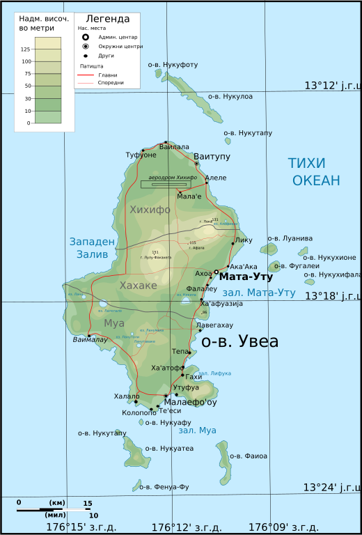
Русский: Топографическая карта островов Уоллис
English: Topographic map of Wallis Island. |
| Date | (UTC) |
| Source | |
| Author |
Original uploader was Boodjoom85 at ru.wikipedia.
|
| Other versions |
|

| This is a retouched picture, which means that it has been digitally altered from its original version. Modifications: translated in Macedonian. The original can be viewed here: Wallis islands map RU.svg:
|
I, the copyright holder of this work, hereby publish it under the following license:
This file is licensed under the Creative Commons Attribution-Share Alike 3.0 Unported license.
- You are free:
- to share – to copy, distribute and transmit the work
- to remix – to adapt the work
- Under the following conditions:
- attribution – You must give appropriate credit, provide a link to the license, and indicate if changes were made. You may do so in any reasonable manner, but not in any way that suggests the licensor endorses you or your use.
- share alike – If you remix, transform, or build upon the material, you must distribute your contributions under the same or compatible license as the original.
Original upload log[edit]
This image is a derivative work of the following images:
- File:Wallis_islands_map_RU.svg licensed with Cc-by-sa-3.0
- 2009-10-20T18:09:00Z File Upload Bot (Magnus Manske) 868x1281 (158810 Bytes) {{BotMoveToCommons|ru.wikipedia|year={{subst:CURRENTYEAR}}|month={{subst:CURRENTMONTHNAME}}|day={{subst:CURRENTDAY}}}} {{Information |Description={{ru|Топографическая карта островов [[:ru:Уолл
Uploaded with derivativeFX
File history
Click on a date/time to view the file as it appeared at that time.
| Date/Time | Thumbnail | Dimensions | User | Comment | |
|---|---|---|---|---|---|
| current | 02:11, 28 February 2010 | | 868 × 1,281 (154 KB) | Bjankuloski06en (talk | contribs) | Enlarged legend and altitude scale boxes. |
| 02:08, 28 February 2010 |  | 868 × 1,281 (155 KB) | Bjankuloski06en (talk | contribs) | {{Information |Description={{mk|Топографска карта островот Валис со придружните острови, дел од земјата Валис и Футуна.}} {{ru|� |
You cannot overwrite this file.
File usage on Commons
The following 2 pages use this file:
File usage on other wikis
The following other wikis use this file:
- Usage on mk.wikipedia.org