File:W & A.K. Johnston. European Russia. 1850.jpg
Jump to navigation
Jump to search
Size of this preview: 483 × 599 pixels. Other resolutions: 193 × 240 pixels | 550 × 682 pixels.
Original file (550 × 682 pixels, file size: 127 KB, MIME type: image/jpeg)
Captions
Captions
Add a one-line explanation of what this file represents
Summary[edit]
| Description |
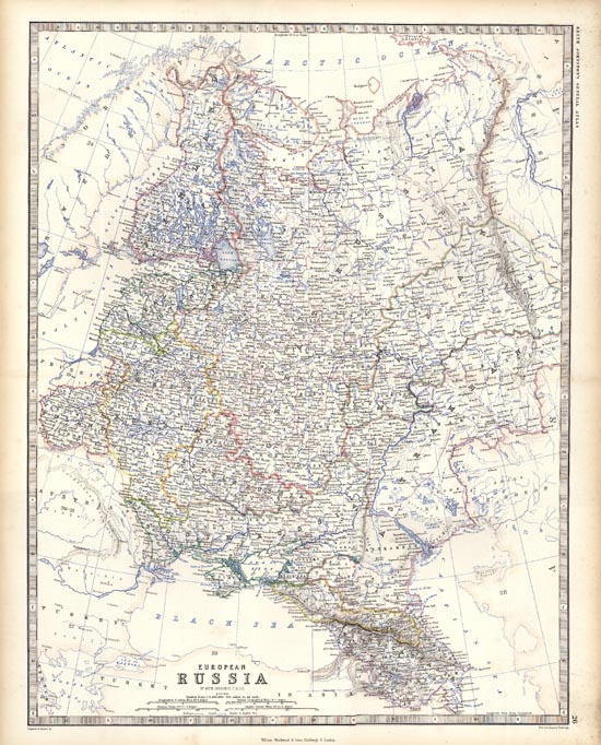
English: W & A.K. Johnston: European Russia. Detailed map of the region. Shows towns, railroads, rivers, lakes, mountains, railroad lines, sub-oceanic Telegraph lines, etc. Decorative Piano Key border. From Johnston's Handy Royal Atlas, one of the most popular English language atlases of the 2nd half of the 19th Century. |
|||||||||||||||||||
| Date | Edinburgh / 1850 | |||||||||||||||||||
| Source | Barry Lawrence Ruderman Antique Maps Inc. | |||||||||||||||||||
| Author |
|
|||||||||||||||||||
Licensing[edit]
|
This is a faithful photographic reproduction of a two-dimensional, public domain work of art. The work of art itself is in the public domain for the following reason:
The official position taken by the Wikimedia Foundation is that "faithful reproductions of two-dimensional public domain works of art are public domain".
This photographic reproduction is therefore also considered to be in the public domain in the United States. In other jurisdictions, re-use of this content may be restricted; see Reuse of PD-Art photographs for details. | ||||
File history
Click on a date/time to view the file as it appeared at that time.
| Date/Time | Thumbnail | Dimensions | User | Comment | |
|---|---|---|---|---|---|
| current | 16:08, 17 May 2011 | | 550 × 682 (127 KB) | Geagea (talk | contribs) | == {{int:filedesc}} == {{Information |Description={{en|1=W & A.K. Johnston: European Russia.<br /> Detailed map of the region. Shows towns, railroads, rivers, lakes, mountains, railroad lines, sub-oceanic Telegraph lines, etc. Decorative Piano Key border |
You cannot overwrite this file.
File usage on Commons
There are no pages that use this file.
File usage on other wikis
The following other wikis use this file:
- Usage on hr.wikipedia.org
- Usage on sh.wikipedia.org