File:WW2 Holocaust Poland map-fr.svg
Jump to navigation
Jump to search

Size of this PNG preview of this SVG file: 688 × 600 pixels. Other resolutions: 275 × 240 pixels | 551 × 480 pixels | 881 × 768 pixels | 1,175 × 1,024 pixels | 2,350 × 2,048 pixels | 778 × 678 pixels.
Original file (SVG file, nominally 778 × 678 pixels, file size: 97 KB)
Captions
Captions
Add a one-line explanation of what this file represents
Summary[edit]
| Description |
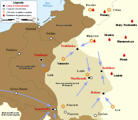
English: Map of the Holocaust in Poland during the Second World War (1939-1945) at the time of German occupation. Français : Carte de la Shoah en Europe lors de la Seconde Guerre mondiale (1939-1945). |
||||
| Date | (UTC) | ||||
| Source | |||||
| Author | |||||
| Other versions |
[]
| ||||
| Attribution (required by the license) | © Sémhur / Wikimedia Commons / | ||||
| SVG | W3C-validity not checked.
|
||||
| Graphic Lab |


.png)


.png)


| Camera location | | View this and other nearby images on: OpenStreetMap |
|---|
Licensing[edit]
I, the copyright holder of this work, hereby publish it under the following licenses:
| Copyleft: This work of art is free; you can redistribute it and/or modify it according to terms of the Free Art License. You will find a specimen of this license on the Copyleft Attitude site as well as on other sites. |
This file is licensed under the Creative Commons Attribution-Share Alike 4.0 International, 3.0 Unported, 2.5 Generic, 2.0 Generic and 1.0 Generic license.
- You are free:
- to share – to copy, distribute and transmit the work
- to remix – to adapt the work
- Under the following conditions:
- attribution – You must give appropriate credit, provide a link to the license, and indicate if changes were made. You may do so in any reasonable manner, but not in any way that suggests the licensor endorses you or your use.
- share alike – If you remix, transform, or build upon the material, you must distribute your contributions under the same or compatible license as the original.
You may select the license of your choice.
Original upload log[edit]
This image is a derivative work of the following images:
- File:WW2_Holocaust_Europe_map-fr.svg licensed with FAL
- 2011-09-28T13:32:55Z Sémhur 1310x1090 (502755 Bytes) Location of Varsovie, border between Poland and East Prussia
- 2009-05-11T16:52:07Z Sémhur 1310x1090 (607330 Bytes) {{Information |Description=Map of the Holocaust in Europe during World War II, 1939-1945. This map shows all extermination camps (or ''death camps''), most major concentration camps, labor camps, prison camps, ghettos, major
Uploaded with derivativeFX
File history
Click on a date/time to view the file as it appeared at that time.
| Date/Time | Thumbnail | Dimensions | User | Comment | |
|---|---|---|---|---|---|
| current | 14:01, 10 October 2011 | | 778 × 678 (97 KB) | Sémhur (talk | contribs) | Simplification des icônes des camps |
| 13:11, 10 October 2011 |  | 778 × 678 (119 KB) | Sémhur (talk | contribs) | Tentative d'amélioration du rendu d'un texte de la légende | |
| 13:08, 10 October 2011 |  | 778 × 678 (119 KB) | Sémhur (talk | contribs) | Ajout de lieux de massacres : Slonim, Baranowicze, Pinsk, Loutsk | |
| 15:00, 3 October 2011 |  | 778 × 678 (116 KB) | Sémhur (talk | contribs) | + Maly Trostenëts | |
| 14:47, 3 October 2011 |  | 778 × 678 (117 KB) | Sémhur (talk | contribs) | Majdanek => Maïdanek Ajout Lublin Symbole de Ponary : sabres => goutte de sang | |
| 17:16, 2 October 2011 |  | 778 × 678 (107 KB) | Sémhur (talk | contribs) | * « L'holocauste » => « La Shoah en Pologne » * « ville et village avec un ghetto » => « ville avec un ghetto important » * Pictogramme les camps de concentration & pictogramme lieu de massacre * Périmètre du gouvernement général * « Lemberg | |
| 18:28, 1 October 2011 |  | 728 × 678 (94 KB) | Sémhur (talk | contribs) | Gouvernement général | |
| 17:08, 29 September 2011 |  | 728 × 678 (102 KB) | Sémhur (talk | contribs) | {{Information |Description={{Multilingual description |en= Map of the Holocaust in Poland during World War II, 1939-1945. |fr= Carte de la Shoah en Europe lors de la Seconde Guerre mondiale (1939-1945).}} |Source=*[[ |
You cannot overwrite this file.
File usage on Commons
There are no pages that use this file.
File usage on other wikis
The following other wikis use this file:
- Usage on cs.wikipedia.org
- Usage on fr.wikipedia.org
- Centres d'extermination nazis
- Auschwitz
- Camp de Majdanek
- Centre d'extermination de Treblinka
- Centre d'extermination de Sobibór
- Centre d'extermination de Chełmno
- Centre d'extermination de Bełżec
- Portail:Nazisme/Sélection d'articles
- Convoi no 50 du 4 mars 1943
- Wikipédia:Lumière sur/Camps d'extermination nazis
- Wikipédia:Atelier graphique/Cartes/Archives/octobre 2011
- Wikipédia:Lumière sur/Centres d'extermination nazis
- Portail:Shoah/Sélection
- Usage on ro.wikipedia.org