File:WW2-Holocaust-Poland-ru.png
Jump to navigation
Jump to search
No higher resolution available.
WW2-Holocaust-Poland-ru.png (364 × 339 pixels, file size: 121 KB, MIME type: image/png)
Captions
Captions
Add a one-line explanation of what this file represents
| Description |
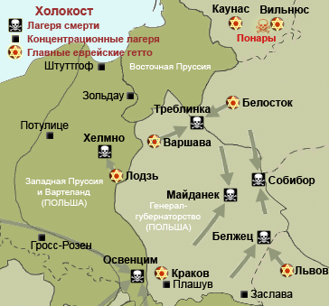
Map of the Holocaust in Poland during World War II, 1939-1945. This map shows all extermination camps (or death camps), most major concentration camps, labor camps, prison camps, ghettos, major deportation routes and major massacre sites. Notes: 1. Extermination camps were dedicated death camps, but all camps and ghettos took a toll of many, many lives. 2. Concentration camps include labor camps, prison camps & transit camps. 3. Not all camps & ghettos are shown. 4. Borders are at the height of Axis domination (1942). 5. Some regions have German designations (e.g. "Ostland"), with the present country name denoted in uppercase letters in parenthesis below the German designation (e.g. "(AUSTRIA)"). 6. Present (2007) borders are dotted. |
| Date | (UTC) |
| Source | |
| Author |
|
| Other versions |
[]
|


.png)


.png)


| This is a retouched picture, which means that it has been digitally altered from its original version. Modifications: Translate to Russian. The original can be viewed here: WW2-Holocaust-Poland.PNG:
|
I, the copyright holder of this work, hereby publish it under the following license:
This file is licensed under the Creative Commons Attribution 3.0 Unported license.
- You are free:
- to share – to copy, distribute and transmit the work
- to remix – to adapt the work
- Under the following conditions:
- attribution – You must give appropriate credit, provide a link to the license, and indicate if changes were made. You may do so in any reasonable manner, but not in any way that suggests the licensor endorses you or your use.
Original upload log[edit]
This image is a derivative work of the following images:
- File:WW2-Holocaust-Poland.PNG licensed with Cc-by-3.0
- 2009-02-19T18:27:36Z Piotrus 364x339 (110907 Bytes) Reverted to version as of 18:22, 19 February 2009
- 2009-02-19T18:26:01Z Piotrus 700x393 (108396 Bytes) Reverted to version as of 18:24, 19 February 2009
- 2009-02-19T18:25:43Z Piotrus 700x393 (108396 Bytes) Added legend from the original map
- 2009-02-19T18:24:31Z Piotrus 700x393 (108396 Bytes) Added legend from the original map
- 2009-02-19T18:22:38Z Poeticbent 364x339 (110907 Bytes) added legend to map
- 2009-02-18T18:34:02Z Piotrus 364x339 (75862 Bytes) {{Information |Description=Map of the Holocaust in Poland during World War II, 1939-1945. This map shows all extermination camps (or ''death camps''), most major concentration camps, labor camps, prison camps, ghettos, major
Uploaded with derivativeFX
File history
Click on a date/time to view the file as it appeared at that time.
| Date/Time | Thumbnail | Dimensions | User | Comment | |
|---|---|---|---|---|---|
| current | 22:38, 17 November 2010 | | 364 × 339 (121 KB) | Bogomolov.PL (talk | contribs) | Исправлено написание Собибур на Собибор |
| 06:07, 12 March 2010 |  | 364 × 339 (102 KB) | Pessimist2006 (talk | contribs) | {{Information |Description=Map of the Holocaust in Poland during World War II, 1939-1945. <br> This map shows all extermination camps (or ''death camps''), most major concentration camps, labor camps, prison camps, ghettos, major deportation routes and ma |
You cannot overwrite this file.
File usage on Commons
The following 24 pages use this file:
- File:WW2-Holocaust-Europe-2007Borders.png
- File:WW2-Holocaust-Europe-2007Borders DE.png
- File:WW2-Holocaust-Europe-he.png
- File:WW2-Holocaust-Europe.png
- File:WW2-Holocaust-Europe DE.png
- File:WW2-Holocaust-Europe DE 2.png
- File:WW2-Holocaust-Europe blank.png
- File:WW2-Holocaust-Poland-ru.png
- File:WW2-Holocaust-Poland-ukr.jpg
- File:WW2-Holocaust-Poland.PNG
- File:WW2-Holocaust-Poland (Français).png
- File:WW2-Holocaust-Poland (without comment).png
- File:WW2-Holocaust-Poland big legend.PNG
- File:WW2-Zagłada-Żydów-Polska.png
- File:WW2 Holocaust Europe N-E map-fr.svg
- File:WW2 Holocaust Europe map-blank.svg
- File:WW2 Holocaust Europe map-es.svg
- File:WW2 Holocaust Europe map-fr.svg
- File:WW2 Holocaust Europe map-it.svg
- File:WW2 Holocaust Europe map-pt.svg
- File:WW2 Holocaust Europe map-zh-hans.svg
- File:WW2 Holocaust Poland map-fr.svg
- File:Холокост в Европе.png
- Template:Other versions/WW2 Holocaust Europe map
File usage on other wikis
The following other wikis use this file:
- Usage on hy.wikipedia.org
- Usage on ru.wikipedia.org