File:WW1-French-plans.png
Jump to navigation
Jump to search
Size of this preview: 197 × 598 pixels. Other resolutions: 79 × 240 pixels | 158 × 480 pixels | 253 × 768 pixels | 337 × 1,024 pixels | 1,600 × 4,860 pixels.
Original file (1,600 × 4,860 pixels, file size: 1.37 MB, MIME type: image/png)
Captions
Captions
Add a one-line explanation of what this file represents

Summary[edit]
| Description |
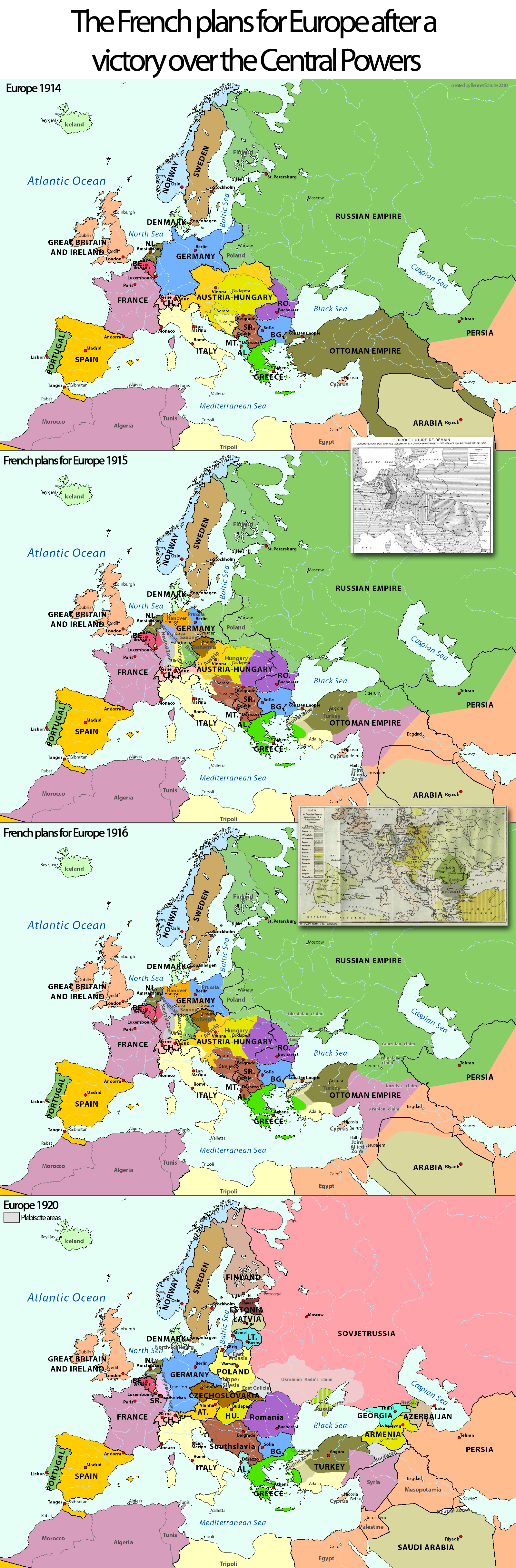
English: Collage of maps on the French plans for Europe after a victory over the Central Powers in the first World War. The Collage includes the source maps for the plans and a map before and directly after the war. |
| Date | |
| Source | Own work |
| Author | Exec |
| Other versions |
|


Licensing[edit]
I, the copyright holder of this work, hereby publish it under the following licenses:
This file is licensed under the Creative Commons Attribution-Share Alike 3.0 Unported license.
- You are free:
- to share – to copy, distribute and transmit the work
- to remix – to adapt the work
- Under the following conditions:
- attribution – You must give appropriate credit, provide a link to the license, and indicate if changes were made. You may do so in any reasonable manner, but not in any way that suggests the licensor endorses you or your use.
- share alike – If you remix, transform, or build upon the material, you must distribute your contributions under the same or compatible license as the original.

|
Permission is granted to copy, distribute and/or modify this document under the terms of the GNU Free Documentation License, Version 1.2 or any later version published by the Free Software Foundation; with no Invariant Sections, no Front-Cover Texts, and no Back-Cover Texts. A copy of the license is included in the section entitled GNU Free Documentation License. |
You may select the license of your choice.
File history
Click on a date/time to view the file as it appeared at that time.
| Date/Time | Thumbnail | Dimensions | User | Comment | |
|---|---|---|---|---|---|
| current | 11:45, 13 August 2022 | 1,600 × 4,860 (1.37 MB) | Claude Zygiel (talk | contribs) | Some détails since discussion files and Olivier Lowczyk, La fabrique de la paix : du Comité d'études à la Conférence de la Paix, l'élaboration par la France des traités de la Première Guerre mondiale, Institut de Stratégie comparée, Paris 2010, ISBN 978-2-7178-5684-2 | |
| 14:07, 16 February 2010 | 1,600 × 4,860 (1.35 MB) | Exec (talk | contribs) | {{Information |Description={{en|1=Collage of maps on the French plans for Europe after a victory over the Central Powers in the first World War. The Collage includes the source maps for the plans and a map before and directly after the war.}} |Source={{ow |
You cannot overwrite this file.
File usage on Commons
The following 6 pages use this file:
File usage on other wikis
The following other wikis use this file:
- Usage on de.wikipedia.org