File:WRBR 221211 GreatNPSBakeoff Graham cracker replica camp buildings5.jpg (b73714d3-ab26-43bc-ac36-7ccd88906d49).jpg

Original file (5,472 × 3,648 pixels, file size: 5.31 MB, MIME type: image/jpeg)
Captions
Captions

|
The categories of this image need checking. You can do so here.
|
.jpg&action=edit&withJS=MediaWiki:Catcheck.js)
Summary[edit]
.jpg&action=edit§ion=1)
| English: WRBR_221211_GreatNPSBakeoff_Graham cracker replica camp buildings5.jpg | ||||
|---|---|---|---|---|
| Photographer |
English: NPS |
|||
| Title |
English: WRBR_221211_GreatNPSBakeoff_Graham cracker replica camp buildings5.jpg |
|||
| Description |
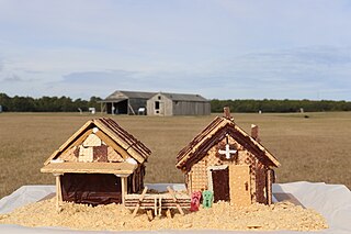
English: Two gingerbread houses in the foreground that resemble the buildings in the background. The gingerbread house on the left resembles a hangar with an overhanging roof. The gingerbread house on the right resembles the camp building, with an open door and two people-shaped jelly candies leaned against it. A small airplane sits in front, made out of wafer cookies. Two gingerbread reconstructions (foreground) of the camp buildings the Wright brothers used in Kitty Hawk, North Carolina (background). A tiny wafer-Wright-Flyer with tiny propellors sits in front!
|
|||
| Depicted place |
English: Latitude: 36.0189583333333, Longitude: -75.6681183333333, Elevation: 15.2; Wright Brothers National Memorial, Dare County, North Carolina; Latitude: 36.0162010192871, Longitude: -75.6701965332031 |
|||
| Date | Taken on 11 December 2022 | |||
| Accession number | ||||
| Source |
English: NPGallery |
|||
| Permission (Reusing this file) |
|
|||
| NPS Unit Code | WRBR | |||
| Album(s) | English: Great NPS Bake Off |
|||
File history
Click on a date/time to view the file as it appeared at that time.
| Date/Time | Thumbnail | Dimensions | User | Comment | |
|---|---|---|---|---|---|
| current | 02:42, 24 June 2023 | | 5,472 × 3,648 (5.31 MB) | BMacZeroBot (talk | contribs) | Batch upload (Commons:Batch uploading/NPGallery) |
You cannot overwrite this file.
File usage on Commons
The following page uses this file:
.jpg)
.jpg&oldid=776976324)