File:Visayan language distribution map new.png
Jump to navigation
Jump to search

Size of this preview: 476 × 599 pixels. Other resolutions: 191 × 240 pixels | 381 × 480 pixels | 610 × 768 pixels | 1,201 × 1,511 pixels.
Original file (1,201 × 1,511 pixels, file size: 174 KB, MIME type: image/png)
Captions
Captions
Add a one-line explanation of what this file represents
| Description |
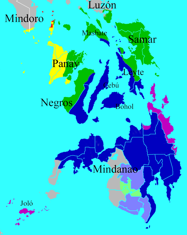
English: This is a map outlining the regions in the central and southern Philippines where the Visayan languages are spoken. The regions are color-coded based upon language family. Note that only the Philippines are included in this map despite the fact that Tausug language is also spoken in East Kalimatan (Indonesia) and Sabah (Malaysia).
English (en): Legend
Cebuano language and dialects like Boholano Significant minorities of speakers of cebuano Significant minorities of speakers of central visayan languages Languages of other families
Español: Este es un mapa del centro y sur de Filipinas con las zonas donde se hablan las lenguas bisayas. Se indican las zonas de predominio de las cinco subdivisiones de este grupo de lenguas, codificadas por colores. Notese que este mapa solamente muestra la extensión de las lenguas bisayas en Filipinas, a pesar de que una de las lenguas del grupo de las bisayas meridionales, el joloano o tausug, se habla también en zonas de Kalimatan Oriental (Indonesia) y Sabah (Malasia).
Las tonalidades más claras indican las áreas donde hay minorías significativas de hablantes de los diferentes subgrupos
Sources/Fuentes:
|
| Date | (UTC) |
| Source | |
| Author |
|
| Other versions |
|

| This is a retouched picture, which means that it has been digitally altered from its original version. Modifications: cropped, legend erased, island names added, blue sea. The original can be viewed here: Visayan language distribution map.png:
|
This file is licensed under the Creative Commons Attribution 3.0 Unported license.
- You are free:
- to share – to copy, distribute and transmit the work
- to remix – to adapt the work
- Under the following conditions:
- attribution – You must give appropriate credit, provide a link to the license, and indicate if changes were made. You may do so in any reasonable manner, but not in any way that suggests the licensor endorses you or your use.
Original upload log[edit]
This image is a derivative work of the following images:
- File:Visayan_language_distribution_map.png licensed with Cc-by-2.5, Cc-by-2.5/en
- 2008-12-27T02:00:33Z Martingala 2000x3120 (273627 Bytes) {{Information |Description={{en|This is a map outlining the regions in the [[:en:Philippines]] where the [[:en:Visayan languages]] are spoken. The regions are color-coded based upon language family. The following sources we
Uploaded with derivativeFX
File history
Click on a date/time to view the file as it appeared at that time.
| Date/Time | Thumbnail | Dimensions | User | Comment | |
|---|---|---|---|---|---|
| current | 20:49, 21 January 2009 | | 1,201 × 1,511 (174 KB) | Martingala (talk | contribs) | {{Information |Description= |Source= |Date= |Author= |Permission= |other_versions= }} |
| 22:04, 29 December 2008 |  | 1,201 × 1,511 (174 KB) | Martingala (talk | contribs) | {{Information |Description={{en|This is a map outlining the regions in the Philippines where the Visayan languages are spoken. The regions are color-coded based upon language family. Note that only the Philip |
You cannot overwrite this file.
File usage on Commons
There are no pages that use this file.
File usage on other wikis
The following other wikis use this file:
- Usage on ast.wikipedia.org
- Usage on es.wikipedia.org