File:View of Vicksburg and plan of the canal, fortifications & vicinity LOC 99447435.jpg
Jump to navigation
Jump to search

Size of this preview: 782 × 600 pixels. Other resolutions: 313 × 240 pixels | 626 × 480 pixels | 1,002 × 768 pixels | 1,280 × 981 pixels | 2,560 × 1,963 pixels | 6,552 × 5,024 pixels.
Original file (6,552 × 5,024 pixels, file size: 7.08 MB, MIME type: image/jpeg)
Captions
Captions
Add a one-line explanation of what this file represents
Summary[edit]
| Description |
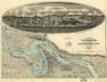
English: Scale 1:63,360. LC Civil War Maps (2nd ed.), 294 Indicates fortifications, location, type and names of boats, roads, railroads, levees, drainage, vegetation, and the names of a few residents. Inset: [View of Vicksburg] 17 x 54 cm. Inscribed in the lower right hand corner "Major David C. Houston, Chief Engineer, 19th Army Corps, with the compliments from the author." Description derived from published bibliography. Available also through the Library of Congress web site as raster image. |
||
| Title | View of Vicksburg and plan of the canal, fortifications & vicinity | ||
| Shelf ID | G3984.V8S5 1863 .W7 | ||
| Date | |||
| Source | https://www.loc.gov/item/99447435/ | ||
| Author | Wrotnowski, L. A. | ||
| Permission (Reusing this file) |
|
||
| Other versions |
|
||
| Location | United States · Mississippi · Vicksburg | ||
| Part of | Civil War Maps · Panoramic Maps · Cities And Towns · Military Battles And Campaigns · Catalog · American Memory · Geography And Map Division | ||
| Subject | United States · Mississippi · Civil War · Vicksburg (Miss.) · Maps · Vicksburg · History |

Licensing[edit]
|
This is a faithful photographic reproduction of a two-dimensional, public domain work of art. The work of art itself is in the public domain for the following reason:
The official position taken by the Wikimedia Foundation is that "faithful reproductions of two-dimensional public domain works of art are public domain".
This photographic reproduction is therefore also considered to be in the public domain in the United States. In other jurisdictions, re-use of this content may be restricted; see Reuse of PD-Art photographs for details. | ||||
.jpg)
File history
Click on a date/time to view the file as it appeared at that time.
| Date/Time | Thumbnail | Dimensions | User | Comment | |
|---|---|---|---|---|---|
| current | 11:22, 10 June 2018 | | 6,552 × 5,024 (7.08 MB) | Fæ (talk | contribs) | LOC Maps https://www.loc.gov/item/99447435/ #10701 |
You cannot overwrite this file.
File usage on Commons
The following 2 pages use this file:
File usage on other wikis
The following other wikis use this file:
- Usage on en.wikipedia.org