File:Verwaltungsgliederung Mähren-Schlesien 1938.svg
Jump to navigation
Jump to search

Size of this PNG preview of this SVG file: 800 × 577 pixels. Other resolutions: 320 × 231 pixels | 640 × 462 pixels | 1,024 × 739 pixels | 1,280 × 923 pixels | 2,560 × 1,847 pixels | 1,741 × 1,256 pixels.
Original file (SVG file, nominally 1,741 × 1,256 pixels, file size: 1,011 KB)
Captions
Captions
Add a one-line explanation of what this file represents
Summary[edit]
| Description |
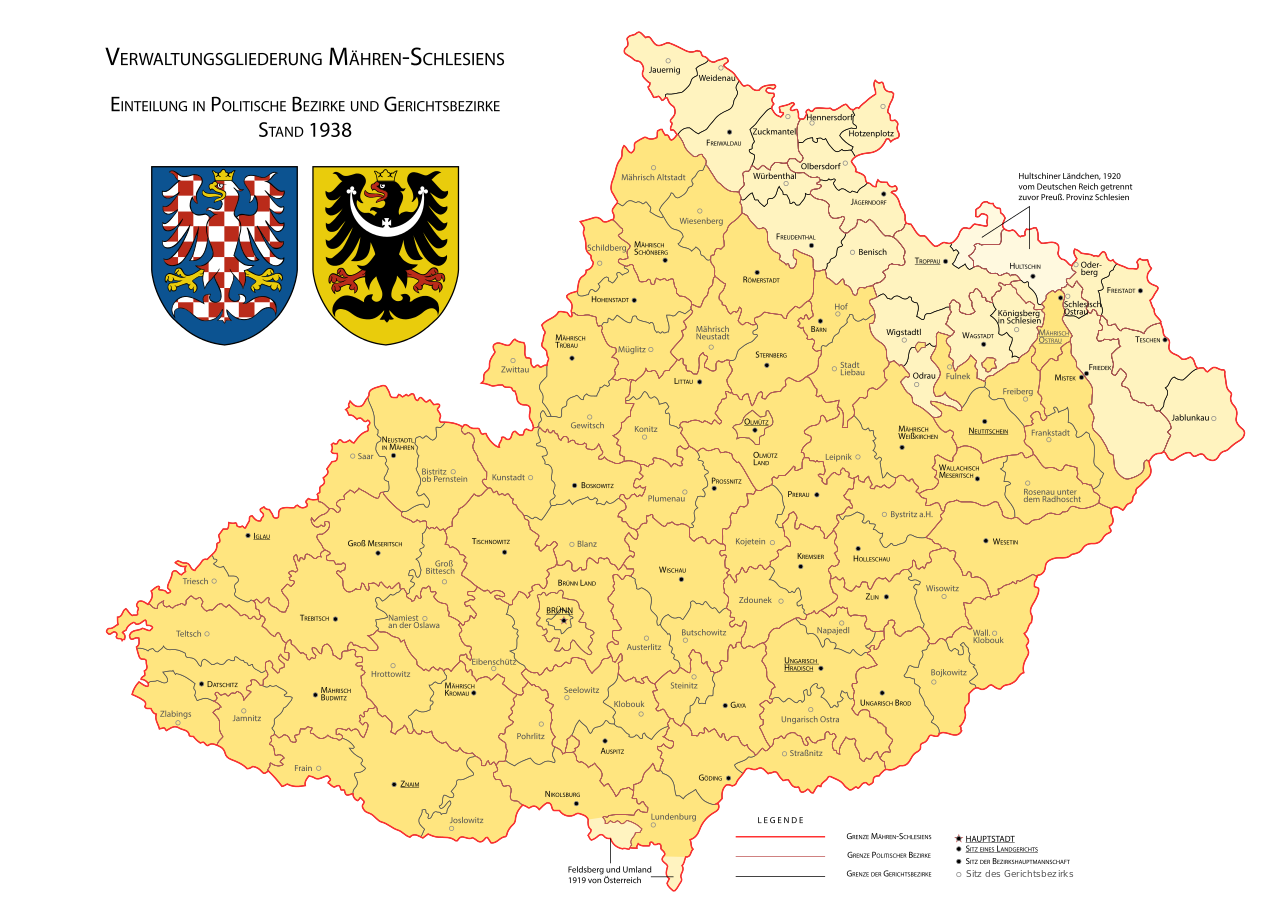
Deutsch: Verwaltungsgliederung des Landes Mähren-Schlesien mit politischen Bezirken und Gerichtsbezirken im Jahr 1938 mit Angabe deutscher Ortsnamen und Hervorhebung der Landesteile Mähren, Schlesien sowie der 1919/1920 hinzugefügten Gebiete (Hultschiner Ländchen und Gemeinde Feldsberg und unbewohntes Gebiet an der Thaya).
Čeština: Soudní a politické okresy v Zemi moravskoslezské v roce 1938. Jména sídel se shodují s jejich tehdejšími úředními názvy. |
| Date | |
| Source |
Own work / including Coat of arms of Moravia |
| Author | David Liuzzo |
| SVG development | This map was created with Adobe Illustrator. |
Licensing[edit]
I, the copyright holder of this work, hereby publish it under the following license:
This file is licensed under the Creative Commons Attribution-Share Alike 3.0 Unported license.
- You are free:
- to share – to copy, distribute and transmit the work
- to remix – to adapt the work
- Under the following conditions:
- attribution – You must give appropriate credit, provide a link to the license, and indicate if changes were made. You may do so in any reasonable manner, but not in any way that suggests the licensor endorses you or your use.
- share alike – If you remix, transform, or build upon the material, you must distribute your contributions under the same or compatible license as the original.
File history
Click on a date/time to view the file as it appeared at that time.
| Date/Time | Thumbnail | Dimensions | User | Comment | |
|---|---|---|---|---|---|
| current | 13:10, 3 February 2016 | | 1,741 × 1,256 (1,011 KB) | David Liuzzo (talk | contribs) | {{Information |Description={{de|Verwaltungsgliederung des Landes Mähren-Schlesien mit politischen Bezirken und Gerichtsbezirken im Jahr 1938 mit Angabe deutscher Ortsnamen und Hervorhebung der Landesteile Mähren, Schlesien sowie der 1919/1920 hinzuge... |
| 19:36, 29 January 2015 |  | 1,741 × 1,256 (999 KB) | David Liuzzo (talk | contribs) | {{Information |Description={{de|Verwaltungsgliederung des Landes Mähren-Schlesien mit politischen Bezirken und Gerichtsbezirken im Jahr 1938 mit Angabe deutscher Ortsnamen und Hervorhebung der Landesteile Mähren, Schlesien sowie der 1919/1920 hinzuge... | |
| 19:29, 29 January 2015 |  | 1,741 × 1,256 (960 KB) | David Liuzzo (talk | contribs) | {{Information |Description={{de|Verwaltungsgliederung des Landes Mähren-Schlesien mit politischen Bezirken und Gerichtsbezirken im Jahr 1938 mit Angabe deutscher Ortsnamen und Hervorhebung der Landesteile Mähren, Schlesien sowie der 1919/1920 hinzuge... |
You cannot overwrite this file.
File usage on Commons
There are no pages that use this file.
File usage on other wikis
The following other wikis use this file:
- Usage on de.wikipedia.org
- Usage on en.wikipedia.org