File:Verlaufskarte Selz.png
Jump to navigation
Jump to search

Size of this preview: 632 × 600 pixels. Other resolutions: 253 × 240 pixels | 506 × 480 pixels.
Original file (800 × 759 pixels, file size: 786 KB, MIME type: image/png)
Captions
Captions
Add a one-line explanation of what this file represents
| Description |
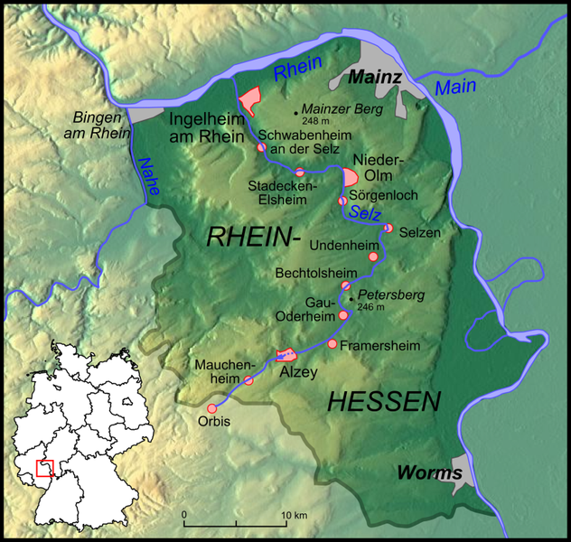
Verlaufskarte Selz in Rheinhessen Cours d'eau de Selz en Rhénanie-Palatinat |
| Date | |
| Source | own work, used Google Maps-For-Free SRTM3 Webserver, Demis Webserver, small map created with Karte_Bundesrepublik_Deutschland.svg |
| Author | Lencer |

|
This map has been made or improved in the German Kartenwerkstatt (Map Lab). You can propose maps to improve as well.
|
This file is licensed under the Creative Commons Attribution-Share Alike 3.0 Unported license.
- You are free:
- to share – to copy, distribute and transmit the work
- to remix – to adapt the work
- Under the following conditions:
- attribution – You must give appropriate credit, provide a link to the license, and indicate if changes were made. You may do so in any reasonable manner, but not in any way that suggests the licensor endorses you or your use.
- share alike – If you remix, transform, or build upon the material, you must distribute your contributions under the same or compatible license as the original.
File history
Click on a date/time to view the file as it appeared at that time.
| Date/Time | Thumbnail | Dimensions | User | Comment | |
|---|---|---|---|---|---|
| current | 19:10, 31 October 2007 | | 800 × 759 (786 KB) | Lencer (talk | contribs) | |
| 19:09, 31 October 2007 |  | 800 × 759 (786 KB) | Lencer (talk | contribs) | ||
| 17:34, 31 October 2007 |  | 800 × 759 (783 KB) | Lencer (talk | contribs) | ||
| 13:48, 31 October 2007 |  | 800 × 759 (765 KB) | Lencer (talk | contribs) | {{Information| |Description=Verlaufskarte Selz in Rheinhessen |Source=own work, used [http://www.maps-for-free.com/ Google Maps-For-Free] SRTM3 Webserver, [http://www.demis.nl/home/pages/wms/demiswms.htm Demis Webserver], |
You cannot overwrite this file.
File usage on Commons
The following 2 pages use this file:
File usage on other wikis
The following other wikis use this file:
- Usage on arz.wikipedia.org
- Usage on ceb.wikipedia.org
- Usage on cv.wikipedia.org
- Usage on da.wikipedia.org
- Usage on de.wikipedia.org
- Usage on en.wikipedia.org
- Usage on eo.wikipedia.org
- Usage on fa.wikipedia.org
- Usage on fr.wikipedia.org
- Usage on fy.wikipedia.org
- Usage on it.wikipedia.org
- Usage on nn.wikipedia.org
- Usage on sv.wikipedia.org
- Usage on uk.wikipedia.org
- Usage on www.wikidata.org
- Usage on zh.wikipedia.org