File:Vegetationszonen.png
Jump to navigation
Jump to search

Size of this preview: 800 × 434 pixels. Other resolutions: 320 × 174 pixels | 640 × 347 pixels | 1,024 × 556 pixels | 1,280 × 695 pixels | 2,560 × 1,390 pixels | 4,779 × 2,594 pixels.
Original file (4,779 × 2,594 pixels, file size: 4.11 MB, MIME type: image/png)
Captions
Captions
Add a one-line explanation of what this file represents
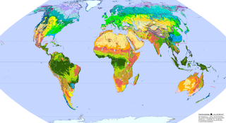
Legende (German)[edit]
Eisschilde u. Gletscher
|
Immergrüner borealer Nadelwald
|
Winterkalte Halbwüsten
|
Trockensavannen
|
Kältewüste
|
Gemäßigte Bergwälder
|
Winterkalte Wüsten
|
Dornstrauch- u. Kakteensavannen
|
Flechten- u. Moostundra
|
Gemäßigte Küsten-Regenwälder
|
Hartlaubvegetation
|
Tropische Trockenwälder
|
Zwergstrauch- u. Wiesentundra
|
Laub- u. Nadelmischwälder
|
Heiße Halbwüsten
|
Regengrüne Feuchtsavannen
|
Bergtundra, alpine Matten u. Heiden
|
Gemäßigte Laub- u. Auenwälder
|
Heiße Wüsten
|
Trop. u. Subtrop. Regengrüne Feuchtwälder
|
Subpolare Wiesen, Heiden u. Moore
|
Gemischte Waldsteppen
|
Hochlandsteppen u. -wüsten
|
Trop. u. Subtrop. Regenwälder
|
Laubholz Waldtundra u. boreale Auen
|
Grassteppen u. Salzwiesen
|
Subtropische Bergwälder
|
Tropische Gebirgsregenwälder
|
Nadelholz Waldtundra
|
Strauch- u. Trockensteppen
|
Subtropische Feuchtwälder
|
Riedsümpfe u. flutende Wasserpflanzen
|
Sommergrüner borealer Nadelwald
|
::: = vegetationslose Wüstenregionen | ⋮¤⋮ = Oasenvegetation (z.T. mit Begrenzung) | ••• = Mangrovenküsten |
| ≡ = Gebirgszüge |
Legend (English)[edit]
Ice Sheets and Glaciers
|
Evergreen Taiga
|
Winter-cold Semidesert
|
Dry Savanna
|
Cold Desert
|
Temperate Mountain Forest
|
Winter-cold Desert
|
Xeric Shrublands and Succulents
|
Lichen and Moss Tundra
|
Temperate Coastal Rain Forest
|
Sclerophyllous Vegetation
|
Trop. and Subtrop. Dry Forest
|
Dwarf Shrub and Meadow Tundra
|
Mixed Forest
|
Hot Semidesert
|
Moist Savannas
|
Alpine Tundra
|
Temperate Broadleaf Forest and Riparian
|
Hot Desert
|
Trop. and Subtrop. Moist Forest
|
Subpolar Meadows, Heaths and Mires
|
Forest Steppe
|
Highland Steppe and Desert
|
Trop. and Subtrop. Rain Forest
|
Broadleaf Forest-tundra and Riparian Taiga
|
Grasslands and Salt Marshes
|
Subtropical Mountain Forest
|
Tropical Mountain Rainforest
|
Coniferous Forest-tundra
|
Shrub and Dry Steppe
|
Subtropical Moist Forest
|
Marsh and Swamp
|
Deciduous Taiga
|
::: = Desert without Vegetation | ⋮¤⋮ = Oasis | ••• = Mangrove |
| ≡ = Mountain Ranges |
Summary[edit]
| Description |
Deutsch: Vegetationszonen der Erde |
| Date | |
| Source |
Own work QuellenKartographie:
Datengrundlagen:Gebirge, Inlandeis:
Grundlage der detaillierten Zonen und Pflanzenformationen:
Daten zur Antarktis:
Weitere zusätzliche Flächen:
Zusammenfassung der detaillierten Pflanzenformationen zu Vegetationszonen
Korrekturen unklarer Flächen und abweichender Recherche-Daten
Vorlesungsunterlagen -sowie- Erläuterungen "Vegetationsgeografie" zum Schweizer Weltatlas -sowie- "Die Vegetationszonen der Erde" im Alexander-Weltatlas (s.o.)
Weitere Quellen
|
| Author | Ökologix |
Licensing[edit]
I, the copyright holder of this work, hereby publish it under the following license:
This file is licensed under the Creative Commons Attribution-Share Alike 3.0 Unported license.
- You are free:
- to share – to copy, distribute and transmit the work
- to remix – to adapt the work
- Under the following conditions:
- attribution – You must give appropriate credit, provide a link to the license, and indicate if changes were made. You may do so in any reasonable manner, but not in any way that suggests the licensor endorses you or your use.
- share alike – If you remix, transform, or build upon the material, you must distribute your contributions under the same or compatible license as the original.
File history
Click on a date/time to view the file as it appeared at that time.
| Date/Time | Thumbnail | Dimensions | User | Comment | |
|---|---|---|---|---|---|
| current | 17:17, 4 June 2020 | | 4,779 × 2,594 (4.11 MB) | Fährtenleser (talk | contribs) | nach Kontrolle Schmithüsen Atlas zur Biogeographie Korrekturen an "Subtropische Trockenwälder" → 80% in Gebirgen zu "Subtropische Gebirgsgehölze", 10% in Flachländern Aufteilung nach jeweiligen Biomen (da die Änderung flächenmäßig weniger als 0,5% umfasst ist keine Änderung der Flächenanteile im Artikel notwendig und entspricht weiterhin auch den verwendeten Quellen) |
| 07:19, 15 November 2015 |  | 4,779 × 2,594 (4.11 MB) | Fährtenleser (talk | contribs) | Korrektur bei den Aleuten, Feuerland, Falkland, Kerguelen- u. Crozet-Inseln nach * J. Schmithüsen (Hrsg.) "Atlas zur Biogeographie". Meyers großer physischer Weltatlas, Bd. 3., Bibliographisches Institut, Mannheim, Wien, Zürich 1976. ISBN 3-411-003... | |
| 06:06, 24 August 2012 |  | 4,779 × 2,594 (4.07 MB) | Fährtenleser (talk | contribs) | In der vorherigen Version fehlten die vegetationslosen Wüstenbereiche Asiens | |
| 19:18, 12 July 2012 |  | 4,779 × 2,594 (4.06 MB) | Fährtenleser (talk | contribs) |
You cannot overwrite this file.
File usage on Commons
The following page uses this file:
File usage on other wikis
The following other wikis use this file:
- Usage on ca.wikipedia.org
- Usage on de.wikipedia.org
- Wüste
- Tropischer Regenwald
- Steppe
- Borealer Nadelwald
- Tundra
- Trockenwald
- Mangrove (Ökosystem)
- Feuchtsavanne
- Bergwald
- Vegetationszone
- Sommergrüner Laubwald
- Trockensavanne
- Waldtundra
- Kältewüste
- Monsunwald
- Wolken- und Nebelwald
- Salzwiese
- Hartlaubvegetation
- Gemäßigter Regenwald
- Dornstrauchsavanne
- Lorbeerwald
- Oase
- Benutzer:Fährtenleser/Landkarten
- Benutzer Diskussion:Fährtenleser/Archiv
- Pflanzenformation
- Vorlage:Navigationsleiste Vegetationszonen
- Vorlage:Infobox Landschaftstyp
- Vorlage:Infobox Landschaftstyp/Doku
- Subtropischer Regenwald
- Wikipedia:WikiProjekt Vorlagen/Werkstatt/Archiv 2022/1
- Hemiborealer Mischwald
- Usage on de.wikiversity.org
- Usage on es.wikipedia.org